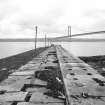
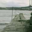
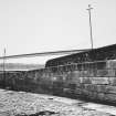
|
Photographs and Off-line Digital Images |
F 3226 |
|
Ferry jetty and pier from North |
1967 |
Item Level |
|
|
Photographs and Off-line Digital Images |
A 82151 PO |
Papers of Professor John R Hume, economic and industrial historian, Glasgow, Scotland |
View from North |
1974 |
Item Level |
|
|
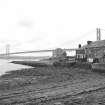
Photographs and Off-line Digital Images |
F 4704 |
|
General view. |
1973 |
Item Level |
|
|
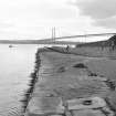
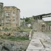
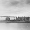
Photographs and Off-line Digital Images |
F 3018 |
|
Ferry jetty (with wall to West) showing extension (left) |
1967 |
Item Level |
|
 |
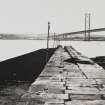
On-line Digital Images |
SC 451869 |
Papers of Professor John R Hume, economic and industrial historian, Glasgow, Scotland |
North Queensferry, Town Pier
View along pier from N, Forth Road bridge in background |
5/10/1974 |
Item Level |
|
|
Manuscripts |
MS 749/812 |
Papers of Professor John R Hume, economic and industrial historian, Glasgow, Scotland |
J R Hume Industrial/CBA cards. Filed under Fife county, Inverkeithing parish, Ferry Pier. Photograph noted. (See NMRS MS/749 entry for Collection description) |
|
Item Level |
|
 |
On-line Digital Images |
SC 554080 |
Papers of Professor John R Hume, economic and industrial historian, Glasgow, Scotland |
North Queensferry, Town Pier
View from NE showing ESE front of pier with Albert Hotel in foreground and Signal House and Forth Road Bridge in background |
1979 |
Item Level |
|
 |
On-line Digital Images |
SC 554084 |
Papers of Professor John R Hume, economic and industrial historian, Glasgow, Scotland |
North Queensferry, Town Pier
View looking SSW along pier with part of Forth Road Bridge in background |
1979 |
Item Level |
|
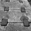 |
On-line Digital Images |
SC 554086 |
Papers of Professor John R Hume, economic and industrial historian, Glasgow, Scotland |
North Queensferry, Town Pier
View showing part of deck of pier |
1979 |
Item Level |
|
 |
On-line Digital Images |
SC 791046 |
Papers of Professor John R Hume, economic and industrial historian, Glasgow, Scotland |
View from SSW looking up pier with tower house in left foreground and rail bridge in background |
1979 |
Item Level |
|
 |
On-line Digital Images |
SC 796165 |
Papers of Professor John R Hume, economic and industrial historian, Glasgow, Scotland |
View from NNE looking down pier with part of Forth Road Bridge in background |
c. 1970 |
Item Level |
|
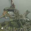 |
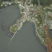
On-line Digital Images |
DP 017234 |
RCAHMS Aerial Photography Digital |
General oblique aerial view of the village centred on the aquarium, signal station, pier and remains of the quarry, taken from the N. |
6/9/2006 |
Item Level |
|
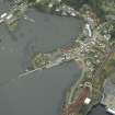 |
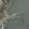
On-line Digital Images |
DP 017236 |
RCAHMS Aerial Photography Digital |
Oblique aerial view centred on the harbour, taken from the SE. |
6/9/2006 |
Item Level |
|
 |
On-line Digital Images |
DP 017238 |
RCAHMS Aerial Photography Digital |
Oblique aerial view centred on the pier and the hotel, taken from the NW. |
6/9/2006 |
Item Level |
|
 |
On-line Digital Images |
DP 017240 |
RCAHMS Aerial Photography Digital |
Oblique aerial view centred on the pier and the hotel, taken from the S. |
6/9/2006 |
Item Level |
|
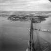 |
On-line Digital Images |
SC 1314960 |
Records of Aerofilms Ltd, aerial photographers, Bristol, England |
Forth Rail Bridge and North Queensferry, Firth of Forth. Oblique aerial photograph taken facing north. This image has been produced from a print. |
25/9/1948 |
Item Level |
|
|
Photographs and Off-line Digital Images |
DP 313932 |
Buildings at Risk Register |
Town Pier, North Queensferry |
29/4/2019 |
Item Level |
|
 |
On-line Digital Images |
SC 2508200 |
|
Ferry jetty (with wall to West) showing extension (left) |
1967 |
Item Level |
|
 |
On-line Digital Images |
SC 2508210 |
|
General view. |
1973 |
Item Level |
|
 |
On-line Digital Images |
SC 2646212 |
|
Ferry jetty and pier from North |
1967 |
Item Level |
|
 |
On-line Digital Images |
SC 2732760 |
Records of the Ordnance Survey, Southampton, Hampshire, England |
North Queensferry, Town Pier, NT18SW 112, Ordnance Survey index card, Recto |
c. 1958 |
Item Level |
|
|
Photographs and Off-line Digital Images |
BP 66/1 |
Historic Scotland Archive Project |
Survey photographs: Unidentified house; unidentified ruin; Crail midden site; Roome Bay and harbour; Anstruther W pier; North Queensferry foreshore, lighthouse (with descriptive plaque) and pier; Carling submarine mining station; Inverkeithing pier; Downing Point beacon; members of survey team. |
1/1996 |
Batch Level |
|
|
Manuscripts |
MS 2307/1 |
Historic Scotland Archive Project |
Survey archive: Photographic register for Coastal Assessment Survey for Historic Scotland, Kincardine to Fifeness. |
4/1996 |
Batch Level |
|


