
Following the launch of trove.scot in February 2025 we are now planning the retiral of some of our webservices. Canmore will be switched off on 24th June 2025. Information about the closure can be found on the HES website: Retiral of HES web services | Historic Environment Scotland
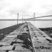
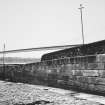
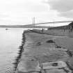
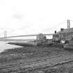
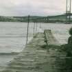
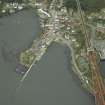
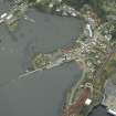
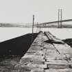
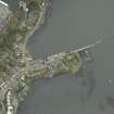
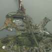
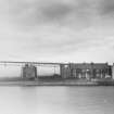
North Queensferry Harbour, Town Pier


Pier (19th Century)
Site Name North Queensferry Harbour, Town Pier
Classification Pier (19th Century)
Alternative Name(s) Ferry Pier; St Margaret's Haven; St Margaret's Bay; Queensferry Narrows; Queensferry Passage
Canmore ID 50917
Site Number NT18SW 98.03
NGR NT 13096 80274
Datum OSGB36 - NGR
Permalink http://canmore.org.uk/site/50917


- Council Fife
- Parish Inverkeithing
- Former Region Fife
- Former District Dunfermline
- Former County Fife
NT18SW 98.03 13096 80274
Formerly entered as NT18SW 112.
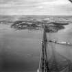
For corresponding Hawes ('Ferry') Pier at South Queensferry, Lothian (NT 13633 78497), see NT17NW 172.00.
Town Pier [NAT]
OS 1:2500 map, 1966.
John Paterson, Engineer
North Queensferry. Pier, W of the battery
Advertisement for tenders, 1805
(Edinburgh Evening Courant, June 29, 1805)
(Undated) information in NMRS.
The location assigned to this record defines the mispoint of the structure. The available (GIS) map evidence indicates that it extends from NT c. 13053 80178 to NT c. 13129 80350.
Information from RCAHMS (RJCM), 6 March 2006.
Publication Account (1999)
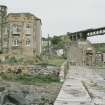
At the foot of the main street are two nineteenth-century buildings with close associations with the Ferry Passage and shipping. The first, a small hexagonal lighthouse figure 14, was erected c 1810. Built of droved ashlar, it is capped with a copper lantern. Nearby, and of a similar date, stands the Tower House, or Signal House, or Mount Hooly figure 10. An octagonal building, with a modern extension to the north, it functioned as the waiting room for ferry travellers and the base of Captain Scott, the first superintendent of the Queensferry Passage. Captain Scott's dwelling house, Seabank Cottage, still stands on the south side of the present main road leading westwards out of the village.
Mount Hooly stands at the head of the Town Pier figure 13. Rebuilt in 1810-13, according to the plans of engineer John Rennie and extended in 1828 by Thomas Telford, this was the landing point for the ferry boats crossing from South Queensferry.
Information from ‘Historic North Queensferry and the Peninsula: The Archaeological Implications of Development’ (1999).

