
Pricing Change
New pricing for orders of material from this site will come into place shortly. Charges for supply of digital images, digitisation on demand, prints and licensing will be altered.
Dumglow


Fort (Prehistoric)
Site Name Dumglow
Classification Fort (Prehistoric)
Alternative Name(s) Drumglow
Canmore ID 49629
Site Number NT09NE 2
NGR NT 0762 9650
Datum OSGB36 - NGR
Permalink http://canmore.org.uk/site/49629


- Council Perth And Kinross
- Parish Cleish
- Former Region Tayside
- Former District Perth And Kinross
- Former County Kinross-shire
NT09NE 2 0762 9650
For cairn within the fort, see NT09NE 4.
(NT 0762 9650) Dumglow (NAT) Promontory Fort (NR)
OS 6" map, (1959).
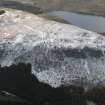
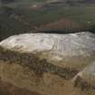
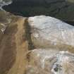
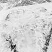
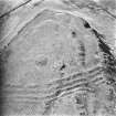
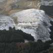
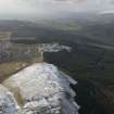
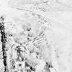
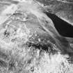
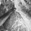
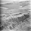
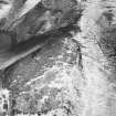
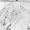
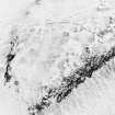
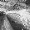
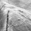
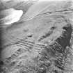
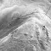
There are the remains of a fort, within which there is a cairn (NT09NE 4) on the summit of Dumglow. The hilltop is bordered to N, W, and S by steep cliffs, but defences have been drawn against approach from the E. These and the cliff-tops contain an area 500' x 400'. The defences consist of four low stony ramparts placed only 12' apart, with an entrance near each end. (See RCAHMS 1933 plan, fig. 453). The ONB records that from time to time, several pieces of urns, swords etc have been found in the ditches.
(R W Feachem 1963; RCAHMS 1933, visited 1927; Name Book 1854).
This fort is generally as described. As well as the two entrances there are several breaks in the ramparts and signs of stone robbing. The interior contains evidence of quarrying but there are no huts visible.
Surveyed at 1:10,000 scale.
Visited by OS (BS) 19 February 1974.
Measured Survey (24 July 1925)
Surveyed at 3 inches to 100 feet. Published at a reduced scale (RCAHMS 1933, fig. 453).
Field Visit (2 August 1927)
Fort, Drumglow.
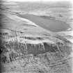
The hill of Drumglow or Dumglow, as it is sometimes called, is one of the isolated peaks of the Cleish Hills and lies a little over a mile to the south-west or Cleish Castle. It rises to a height of 1241 feet above sea-level, and on the summit are the remains of a fort, within the precincts of which there is a fine cairn or mound. The site is unusually strong one, the hill-top being exceedingly difficult of access from all directions. The only possible lines of approach are from the north-east and south-east by tortuous winding courses along the hill-side. The north and south sides are rocky and precipitous, and the westside, though not quite so rugged, is unusually steep. Artificial protection was therefore necessary only on the east where no fewer than four lines of defence have been constructed at intervals which average about 12 feet. These lines, which seem to have been mainly composed of earth and stone, are now very much broken except towards their northern extremities, and are sometimes hardly distinguishable. This is one of the rare instances, so far recorded in the Inventories, of a fort and cairn in association.
RCAHMS 1933, visited 2 August 1927.
Field Visit (13 April 1951)
NT 075 965. There is nothing to add to the plan and description given in the Inventory (RCAHMS 1933).
Visited by RCAHMS 13 April 1951.
Field Visit (August 1991)
NT09NE 2 0762 9650
For cairn within the fort, see NT09NE 4.
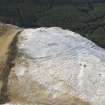
This large fort occupies the whole of the summit area of Dumglow, although the main defences, which comprise up to four ramparts with intermediate ditches, extend across the crest of the hill in a gentle arc to the E of the OS triangulation station. They cut off an area measuring about 150m from E to W by 120m transversely (c1.4ha), at the W end of the summit area, and are pierced by a single entrance close to the crags on the S. However, there are also traces of at least one rampart extending around the E end of the summit area, suggesting the presence of a much larger enclosure of about 3.75ha. This rampart has been reduced to little more than a low stony bank which can be traced along the edge of a shallow gully on the ESE, and there are also traces of a second stony bank on the slope below. The only feature visible within the fort is the burial cairn beneath the OS triangulation pillar.
Visited by RCAHMS (SPH) August 1991.
Note (20 July 2015 - 13 December 2016)
This unusual fort, which occupies the W end of the summit area of Dumglow, on the northern fringe of the Cleish Hills, is configured as a promontory fortification, with its belt of four ramparts some 25m deep barring access from the E and no evidence of a rampart extending around its craggy margin on the N or S. The triangular interior measures about 150m from E to W by a maximum of 130m transversely at the E end. The ramparts are relatively slight, and the three outer ones are separated by shallow ditches. A well-defined entrance lies at the N end of the defences, where the outer ramparts apparently return and unite around the terminals of the ditches to form an entrance passage. The plan surveyed in 1927 by Charles Calder (RCAHMS 1933, 290, no.549, fig 453), fails to show these returns, merely terminating the ramparts to either side of the gap, but a second entrance is shown with this feature at the S end of the defences, albeit that this sector is heavily disturbed and it is not clear in its present state whether there was originally a gap here. Apart from a large circular burial cairn occupying the very summit of the hill, parially excavated by Abercromby in 1904, the interior is featureless. In 1991, RCAHMS investigators raised the possibility that there was an outlying rampart enclosing a much larger area on the E, but a revisit (SH) in 2014 dismissed this as a natural feature.
Information from An Atlas of Hillforts of Great Britain and Ireland – 13 December 2016. Atlas of Hillforts SC3203
Field Walking (1 April 2019 - 2 April 2019)
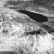
A desk based assessment and walkover survey was undertaken by Guard Archaeology between the 1st and 2nd of April, 2019 of an area proposed for afforestation at Loch Glow in Perth & Kinross.
The assessment indicates that there are nine known cultural heritage sites within the area proposed for afforestation that could potentially be directly affected by the proposal. These consist of a prehistoric fort, a possible cairn, two boundary stones, a shieling hut, a farmstead, two buildings and field banks. None of these sites is designated and all are of regional, local or lesser cultural heritage significance. A further 18 cultural heritage sites, including one Scheduled Monument, one Conservation Area and one Inventory Garden and Designed Landscape, are located within the surrounding 1 km buffer. One previous archaeological assessment has been carried out within 1 km of the Site.
Information from: Christine Rennie (Guard Archaeology) 23rd May, 2019
OASIS ID: guardarc1-348247

