
Nisbet


Ring Ditch House(S) (Prehistoric), Settlement (Prehistoric)
Site Name Nisbet
Classification Ring Ditch House(S) (Prehistoric), Settlement (Prehistoric)
Alternative Name(s) Coulter
Canmore ID 48746
Site Number NT03SW 15
NGR NT 0443 3329
Datum OSGB36 - NGR
Permalink http://canmore.org.uk/site/48746


- Council South Lanarkshire
- Parish Culter
- Former Region Strathclyde
- Former District Clydesdale
- Former County Lanarkshire
Measured Survey (17 July 1958)
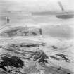
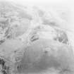
RCAHMS surveyed this site by plane-table on 17 July 1958 at a scale of 1mm:1ft as part of a survey of marginal land. The resultant plan was checked prior to being drawn up in ink in 1975 and published at a reduced scale in the County Inventory of Lanarkshire (RCAHMS 1978, Fig. 40).
Field Visit (18 July 1972)
NT03SW 15 0443 3329
(NT 0443 3329) Settlement (NR)
OS 6" map, (1962).
When seen in 1972, this settlement was generally as described by the RCAHMS, although only one ring-ditch house was recognised.
Resurveyed at 1:2500.
Visited by OS (DWR) 18 July 1972
Field Visit (July 1975)
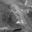
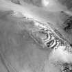
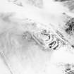
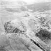
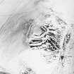
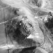
NT 044 332. A settlement, measuring internally about 37m by 30m, stands on the NE end of a steep-sided ridge, some 820m NE of Nisbet farmhouse. It has been enclosed originally by a boulder-faced, rubble-cored wall, probably not more than 3m thick, now represented by a low scarp or crest-line on all sides except the S and SW where it survives as a grass covered stone bank measuring 6m in maximum thickness. Three outer facing stones are visible in situ as shown on the RCAHMS 1978 plan (see fig.40). The bank stands as much as 1.8m above the ground outside but only 0.3m above the interior. The entrance was probably situated on the SE.
The interior contains traces of two ring-ditch houses, the more easterly of which measures about 12.2m in diameter over a ditch 1.8m wide. In both cases there are traces of a very low bank on the inner lip of the ditch, but the significance of this feature is uncertain.
RCAHMS 1978, visited July 1975
Aerial Photographic Interpretation (April 1991)
Visible on vertical air photograph (OS 71/505/603, flown 1971)
Information from RCAHMS (RJCM) April 1991

