
Stirling Castle


Castle (Medieval), Midden (Period Unassigned), War Memorial(S) (20th Century)
Site Name Stirling Castle
Classification Castle (Medieval), Midden (Period Unassigned), War Memorial(S) (20th Century)
Alternative Name(s) Stirling, Castle Rock
Canmore ID 46245
Site Number NS79SE 6
NGR NS 7900 9400
NGR Description Centred NS 7900 9400
Datum OSGB36 - NGR
Permalink http://canmore.org.uk/site/46245


First 100 images shown. See the Collections panel (below) for a link to all digital images.
- Council Stirling
- Parish Stirling
- Former Region Central
- Former District Stirling
- Former County Stirlingshire
(NS 790 941) Castle (NR)
OS 6" map (1913/38)
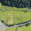
For adjacent King's Knot, see NS79SE 7.
NS79SE 6.01 NS 78996 94035 Palace (of James V)
NS79SE 6.02 NS 78984 94096 Chapel Royal
NS79SE 6.03 NS 79044 94025 Ladies' Lookout (forework or bastion)
NS79SE 6.04 NS 79017 94077 Great Hall (Old Parliament House)
NS79SE 6.05 NS 79030 94095 Mint
NS79SE 6.06 Centred 78961 94073 The King's Old Buildings
NS79SE 6.07 NS 7906 9401 Outer Defences
NS79SE 6.08 Cancelled
NS79SE 6.09 NS 79049 94068 Grand Battery, Kitchen Range
NS79SE 6.10 NS 79049 94068 Esplanade, Monument
NS79SE 6.11 NS 79050 94038 Governor's House
NS79SE 6.12 NS 79090 93952 Esplanade, South African War Memorial
NS79SE 6.13 NS 79123 93983 Esplanade, Robert the Bruce Monument (Bruce's Statue)
NS79SE 6.14 NS 78954 94116 Douglas Garden, Sundial
NS79SE 6.15 Centred NS 79234 93937 Married Quarters' Barracks
NS79SE 6.16 Centred NS 78468 93175 King's Park and Boundary Walls
NS79SE 6.17 NS 79064 94043 Regimental Headquarters
NS79SE 6.18 Centred NS 78967 94153 Nether Bailey
NS79SE 6.19 79002 94008 Queen Anne Garden, Sundial
Full description in official guidebook by Richardson and Root.
J S Richardson and M E B Root 1948.
In October 1992, a twelve-day watching brief was held at Stirling Castle in the area of the eastern Counterguard, further to the excavations conducted in the same area earlier in the year. The various holes against the ramp wall and in the casemates of the Overport Battery indicated that the area had been subject to a massive programme of landfilling during the construction of the Queen Anne defences. Further N, the digging of a pipe trench revealed two retaining walls, probably of a similar date to the landfilling. A stone-lined well, filled in the early 1700s, was revealed against the Mary of Guise wall constructed in the mid-16th century upon which the Overport Battery was built. Much Scottish green glazed pottery was recovered, as well as fragments of bottle glass and clay pipe.
Sponsor: Historic Scotland
G Ewart 1992.
A programme of fieldwork was concentrated on two areas of the post-medieval defences of the castle in advance of prposed development. Area 1: The Interior of a building variously described as the Cart Shed or Straw Store. Area 2: An extensive area in front of the main 16th century facade and N of the Queen Anne casemates.
Area 1: Excavation Report
After the concrete floor from the interior of the Cart Shed was lifted, a series of soft earth deposits were ultimately removed down to bedrock over most of the area. The finished levels were specified by the required depth from architects' plan, so wherever that level was reached, excavation stopped. The broad phases of activity in this trench can be summarised as: Phase 1: Two apparently independent routes up to castle rock cut in bedrock. Phase 2: Defensive ditch and roadway wall built. Phase 3: Timber building constructed over infilled phase 2 wall and ditch. Phase 4: Straw Store/Cart Shed built. Phase 5: Cart Shed converted by demolition of N wall.
Phase 1
The Castle rock itself is a tightly jointed doleritic sill with pronounced regular bedding planes. Where exposed in Area 1, the bedrock surface showed signs of much weathering and wear (much more pronounced than the bedrock found in Area 2) and apart from efforts to prize sections of the sill apart to create space for Phase 3 timbers, showed sign of particular wear in 2 areas. To the SW of Area 1 two lines of 'wear' apparently evidence of vehicular traffic, were picked up, running down towards the SW. This roadway showed signs of having been levelled up and repaired with mortar rubble, resulting in a full width of 1.6m. Part of an arguably earlier trackway was picked up towards the N of Area1. This took the form of a pronounced gully or rut worn into bedrock, truncated by later ditch and associated wall F.040 and which may well be the southern side of a road, predating the ditch and wall construction of Phase 2.
Phase 2 c 1550-c1670
The S route was retained as main access to the Castle during the period of the pre-Queen Anne rebuilding programme. The creation of the French Spur saw the excavation of a deep ditch to the SE and protecting the main entrance route. Part of the ditch appeared at the NW corner of Area 1, underlying part of the N wall of the Cart Shed. It was cut against bedrock but may well be an enhancement of a natural outcropping. The ditch was tested to a depth of 2m and was not bottomed. A light mortar bonded wall lat across the southern side of the ditch - built directly onto the bedrock. This wall (F.040) was poorly preserved but proved to be 500mm wide and despite being truncated by the N wall of the Cart Shed, ran for a distance of 4.8m.
Phase 3.
The Phase 2 wall was demolished and levelled down to 2 or 3 courses, and its associated ditch was infilled with an homogeneous dump of dark earth and stones. The area was generally levelled up to receive a series of timber pads and post holes, reflecting at least one long wall of a timber building aligned E/W. There were in total 3 positive post holes (F.032, 023, 012) with one possible (F.024) with 2 pads (F.025 and 016). The settings were formed from the rubble infill of a series of crudely excavted areas on the bedrock, following the approximate line of the N edge of the Phase 2 trackway. The post settings were essentially squared voids 200mm by 200mm, and 1.5m apart. There was a possible entrance towards the W edge of the line, between the posts F.025 and F.012, defined by a door post stone (F.019). The role of pads F.025 and more enigmatically F.016 is not clear, and it
may be that the timber settings reflect enclosures rather than roofed structures. In any event, it seems that the Phase 3 timbers were temporary precursors to the Straw Store/Cart Shed which was in place by 1860.
Phase 4
The foundations for the Cart Shed walls were cut against the accumulated floor/occupation surfaces from Phase 3 activity, set within irregular foundation trenches, which varied in width from 150mm to 300mm. The depth of the distinctive shaped foundations also varied- deepening considerably to hit towards the SE, a depth of 1.2m. Once a level footing for the faced masonry was in situ, the floor was laid, characterised by mortar spreads (recycled builders' debris). Then the walls were raised to full height, with an apparent door towards the W end of the N wall. This was reflected by a distinctive recess in the S face of the N wall at this point and an equivalent projection of the N face. This does not admittedly concur with the 1860 plan which shows a centrally placed door in the N wall but no signs of such were revealed in the excavation due to damage in Phase 3.
Phase 5
The present open N wall with squared ashlar pillar was formed by the demolition of the Phase 4 N wall to virtually foundation level and the raising of floor and immediate exterior surfaces by 300mm. This was ultimately concreted over and saw use as a 'garage'.
Conclusion
The significance of the excavation in this area can be summarised as: (1) The identification of late medieval access to the castle truncated by 16th century works. (2) The presence of temporary wooden structures predating mid 19th century cart shed/straw store.
Area 2: Excavation Report
The earliest feature revealed on the site was a cut in the granite bedrock in the NW corner of the trench. The natural cleavage of the rock had been exploited to exaggerate a natural drop or, possibly, in order to create a ditch. The line of the feature respected the early 16th century castle frontage and may be a defensive feature associated with this, or perhaps an earlier phase if this is a raised position.
The excavations uncovered a length of the wall built during the regency of Mary of Guise c1559 (shown on Slezer's 17th century plan). This ran S from the section excavated in the late 1970's.
Presumably there must have been a certain amount of landfill between this wall and the early 16th century frontage, but these deposits were not reached before the required depth of excavation.
The Mary of Guise wall was used as the foundation for the battery defences built between 1708 and 1714 during the reign of Queen Anne. It seems likely that the battery wall and casemates were built almost free standing - certainly no foundation trenches were noted. The ramp wall leading down into the area was also built in this phase. Once the lower courses of these structures were laid, material was dumped against them to secure them and to raise the level of the area in general.
The original base levels of the ramp and casemate walls was indicated by the quoins uncovered reflecting a ground surface approximately 1.5m below that of the modern one.
On the 1725 plan of Stirling, the ramp wall is not shown, although the structural details are exactly the same as those of the casemate corners. However this plan shows the battery wall and the casemate extending further than they do today. There is evidence for this on the site - although not for a 2-floor barrack. A well-constructed mortared square plinth F127 was found which was inline with the casemate frontage and exactly the width of an arch from the surviving casemates. The lack of demolished wall, signs of bonding to the battery wall or remnants of vaulting suggests that the end structure was for a different purpose - possibly an outhouse for large pieces of equipment such as artillery or carts.
It is not known for how long the Queen Anne battery and casemates were used in their original form, but at some point (or points) before 1860 the layout of the area radically changed. The end casemate was demolished and the ramp wall was foreshortened. A long subdivided lean-to (three foundation piles for which were excavated) was placed against the early 16th century castle frontage and another built where the end casemate stood. The whole ground level for the area was raised by approximately 1m including within the casemates. The ramp down into the area was raised and formed by the considerable dumping of rubble given a smoother surface by the use of mortar. Cobbles/sets may also have been used over this.
However, by the late 1860's the lean-to against the 16th century frontage had been demolished, the casemates were contractors stores and the lean-to on the site of the demolished end casemate was used as an engine house. This structure was used until 1991 when it was demolished. The access routes and general ground levels in the area remained much the same as in the 19th century, the only real changes being the laying of electricity and telephone cables and the late 1970's excavations.
Thus, despite the slightly unpromising nature of the area to then be excavated, features dating from the late-medieval period onwards were uncovered, the history of the use of the Mary of Guise and Queen Anne period defences elucidated the survival of early 18th century deposits (and their contents) confirmed.
Sponsor:Historic Scotland
G Ewart 1992.
A series of small-scale excavations and watching briefs were completed between March and May 1993 as part of the major ongoing programme of rebuilding and upgrading at the Castle. The results of this most recent fieldwork can be summarised in terms of the four areas of the Castle effected.
1. The Overport Battery Casemates and Trance
(part of the new restaurant development)
During the removal of 19th and 20th century levelling deposits a remnant of a defensive line, predating the Queen Anne works, was discovered in Casemate 1.
2. Guard Room Square
Beneath elements of the southern Queen Anne defences, slight evidence of the earlier southern access route on to the site was traced in the form of worn and weathered bedrock.
3. The Lower Square
During the excavation of a series of pipe and service trenches, water conduits - both for drainage and water supply, were found, the earliest of which dated to the Queen Anne rebuilding programme. Also, some crude stonework with associated midden deposits, were discovered towards the SE of the Great Hall. These features are provisionally dated to the late 15th/early 16th century and represent levelling up, whether casual or deliberate, over the steeply shelving bedrock to the E of the Great Hall, down to the North Gate.
4. The Queen Anne Battery Casemates
The interiors of four of these chambers were cleared of 19th and 20th century infill, down to primary (early 18th century) occupation levels. Evidence of wooden floors and large squared hearths in each was found, all of which were later obscured by the raising of the floors throughout the range towards the middle of the 19th century.
Sponsor: Historic Scotland
G Ewart 1993.
NS 790 940. Limited excavation was completed at the E end of the Chapel Royal, while floors were removed in advance of comprehensive repairs. The findings of the excavation within the late 16th-century chapel, comprised a massive series of tipped deposits containing quantities of demolition debris, midden deposits and construction debris up to approximately 5m deep, laid to create a floor base for the Chapel Royal. The probable northern wall of the preceding chapel as refurbished by James III and IV was found running diagonally across the interior of the later Chapel Royal. This wall, along with the wall defining the W side of the 'Transe' (which gave access to the Great Hall of James IV) defined an (open?) area between the earlier chapel and the outer curtain. Access to this area was via a well-formed doorway leading into the Transe, but which was blocked when the infilling process began when the Chapel Royal was built (1580-94).
Quantities of bronze slag along with firebricks were found in the lower tips within the Chapel Royal, apparently evidence of a demolished metal working complex. Large quantities of animal, bird and fish bone along with a good assemblage of pottery (mainly jugs and cooking pots) were found among the midden tips, generally towards the bottom of the series.
Sponsor: Historic Scotland.
G J Ewart 1994
Ns 790 940 Excavation in the Chapel Royal and Lion's Den continued in the autumn of 1994 in advance of restoration and renovation. Work in the Lion's Den (the inner quadrangle of the 16th century Palace) revealed evidence of contemporary or later activities associated with the Palace. However, fragments of masonry were found in the extreme SE corner of the area, which relate to earlier 16th century buildings, but which were recycled for use in the present layout (built during the 1540s).
Elsewhere, a substantial retaining wall was found towards the S side of the Lion's Den, which appears to have defined the southern limits of the quadrangle layout. This in turn was probably formal and decorative, possibly some sort of parterre arrangement. The polygonal-shaped building discovered in previous excavations and located towards the middle of the area retained by the low S wall, along with a drain or sump lying towards the NE corner of the area, may have been integral to the formal layout. These were heavily altered and damaged by later occupancy of the Palace block. Certainly the polygonal building was used as a cistern serving 19th century lavatories.
In general the extent of damage to the 16th century layout was such as to have almost entirely removed most features and surfaces predating the extensive pipe laying and resurfacing activities of the 19th and 20th centuries.
In the Chapel Royal, the excavation begun in the summer of 1994 continued to bedrock, removing the remaining tips of debris which had been deposited as levelling for the floor of the Chapel Royal (built in 1594). This exercise resulted in a trench over 5m deep, the lower fills of which contained considerable amounts of firebrick and metal slag, apparently evidence of a demolished forge or foundry. Elsewhere within the Chapel Royal, traces of two earlier structures were found, one of which is assumed to be the late 15th century precursor to the 1594 chapel, and which in turn had truncated a smaller, as yet unidentified rectangular lime mortared stone building.
In the Mint, the unblocking of two large fireplaces was monitored- the larger in the N wall, with the second in the E wall. Both of these massive features, thought to date to the late 15th century, had been much altered from the 17th century onwards, with relatively little surviving of primary hearth surfaces.
Sponsor: Historic Scotland.
G Ewart and P Sharman 1995.
NS 7990 940 In advance of the re-roofing of the Chapel Royal, a programme of excavation was mounted over December and January of 1994-5 in the Upper Square and Douglas Gardens within the Castle.
The Upper Square: Two trenches were opened in the Upper Square. The earliest structure found was the SE corner of a stone building. This was formed by a SW-NE wall and its return, extending NW. The SW corner of the same building was seen in the 1994 excavation inside the Chapel Royal. This structure was aligned NE-SW. It measured c13.1m NE-SW and was at least 4m wide, although the northern limit was not seen.
A large amount of charcoal, ash and metalworking debris was recovered in the upper layers associated with the usage of this building, perhaps suggesting that the latest occupation was industrial. However, it may be that the building was originally an earlier version of the Castle Chapel, predating the 15th century Chapel.
The second phase of activity involved the construction of the 15th century Chapel, parts of which were also revealed throughout the trench, showing it to be at least 29m long and some 9m wide, aligned ENE-WSW.
The discovery of drystone structures within the levelling material prior to the construction of the 15th century Chapel suggest that it had two building phases, the first involving a crypt which was filled in at a later date to stabilise the masonry above, probably part of the documented 1505 repairs.
The other major structure studied in the Upper Square was the present Chapel Royal, known to date to 1594. A complete pottery vessel was found standing upright in the construction trench for the S wall of the Chapel. This pot was almost identical to vessels recovered from beneath the floor of Innerpeffray Church in Perthshire, these examples having been dated to the period 1508-1650.
There were at least eighteen different masons-marks noted on and around the string course of the S Chapel wall.
The Douglas Gardens: A total of six trenches were opened in the Douglas Gardens. The earliest remains comprised part of a wall aligned SE-NW, comparable to structures in the Upper Square, and finds recovered from this period of activity seemed to indicate an early-mid 14th century date for its demolition.
Built on top of this early wall was a retaining wall with a bank behind (to the W of) it. This revetment may have incorporated part of the earlier wall, which had by this stage been partially demolished. The bank seems to have stood to a height of c1.3m, and finds from its surface indicate late 15th-early 16th century activity.
Sponsor: Historic Scotland.
G Ewart and A Radley 1995.
NS 790 940 Fieldwork during summer 1995 concentrated mainly on excavation in the Upper Square, over and immediately adjacent to the late 18th-early 19th century cistern, which lies to the W of the Great Hall Transe. Further work comprised the monitoring of the excavation of a series of 11 small pits to receive information boards. One of these holes, located in the Queen Anne Gardens, revealed a lime-mortared wall, possibly that shown on the 17th century plan by Slezer. The remaining holes revealed little of archaeological significance, aside from levelling material.
The earliest features revealed in the main excavation comprised a series of occupation surfaces, truncated during the construction of the cistern. These deposits were only revealed in a narrow strip, on average 1m in width, but represent a complex series of early medieval occupation horizons. The medieval occupation is most obviously characterised by a hearth-site, which in turn probably relates to a series of crude structural timber settings, and floor surfaces. Overlying this sequence of deposits were tip-lines and courtyard levels associated with the construction, occupation and demolition of the 15th century Chapel Royal.
The Transe wall was built in two phases, the upper section relating to the vaulting-over of the Transe itself during the later 16th century.
The cistern was revealed in its entirety, showing it to be 15.5m long N-S by 4.25m wide, and of high quality sandstone construction. It had been much altered and repaired since its original construction, affecting both its supply and capacity, and access to it. The capacity of the tank was c120m3 (c26,400 gallons), and it was intended to provide water in the event of fire.
Sponsor: Historic Scotland.
G Ewart and P Sharman 1995.
NS 790 940 Excavation within the Great Hall comprised the recording of a series of cross-walls dating from the later 18th century conversion of the Hall to barrack accomodation. These walls sub-divided the ground floor into four chambers, with two staircases leading to upper floors. The walls themselves were of massive lime-mortar construction, and two of them featured flues serving fireplaces within the vaulted basement.
The Great Hall floor was recorded in detail, and evidence of both its original pattern and its subsequent damage to receive later floor surfaces and modifications to the internal arrangement of the Hall was noted. It appears that the pattern of floor slabs reflected some sub-divisions within the Hall as completed during the early years of the 16th century.
In addition, two trenches were excavated in advance of the re-roofing of the Great Hall. Of these trenches, one lay to the S of the Hall, and contained considerable deposits of charcoal, alongside pottery of 14th and 15th century type. The second trench was cut at the base of the E wall of the Palace. The excavation of this trench was curtailed by the presence of modern services.
Sponsor: Historic Scotland.
G Ewart and A Radley 1995.
NS 790 940 A series of excavations were undertaken at Stirling Castle by Kirkdale Archaeology during 1996-7, as part of the ongoing refurbishments to the buildings in the Upper and Lower Squares.
W wall of the Great Hall
Three 1sqm holes were opened against the W side of the Great Hall, on top of the transe vault. Surviving patches of harling on the wall of the Great Hall provided samples for analysis. The top of the transe had been revealed before in excavations.
Army kitchens
Two small rooms were investigated in the E end of the building used as the army kitchens between the S end of the King's Old Buildings and the NW corner of the palace. The aim was to reduce the levels in these rooms by approximately 0.8m in order to provide an access route from the palace porch via a currently blocked doorway into the range. The grey stone paving slabs were removed by a Historic Scotland squad.
It would seem that up to almost 1m of deposits survive below the floor of the army kitchen range, including important information about the medieval castle. The presence of graves indicates that the shell of this building may, despite its later appearance, be that of the other chapel at the castle, possibly that used for private worship by the monarchy, situated as it is between the King's Old Buildings and what is thought to be the site of the queen's lodgings.
The Transe
An excavation was undertaken within the transe on the W side of the Great Hall, with the intention of excavating to bedrock and recording the structure itself. The uncovering of setts in the S part of the transe meant that the brief was changed in order to leave the surface in situ.
The features in the transe fell into seven basic phases, the first one being that which encompassed the worn surface of the bedrock and the surviving patches of surfaces earlier than the transe wall, giving some idea of what the ground surface was like when the Great Hall was constructed at the end of the 15th century. It may be that the lower doors and the window were visible giving an added impression of height to the Hall. It is possible that the W transe wall was built at the same time as the Great Hall, in order to support the lean-to roof which ran along its W side. No evidence was found for the method of access to the main door of the Great Hall. It is assumed that a bridge across the unroofed transe to the door is the most likely solution, although the Chapel Royal prior to the upstanding building would have blocked this access somewhat. The surface of the transe floor yielded no evidence for a staircase against the face of the Hall.
The fourth phase was that of the E-W transe added to the N side of the Great Hall, with a lean-to storey on top, presumably done at some point in the 16th century. The uncertainty of the structural sequence at the N end of the transe possibly reflects a complicated sequence of construction and adaptation of upstanding structures in order to support the range and/or the later vestibule built to connect the Great Hall and the Chapel Royal in the 17th century. There is evidence of a blocked door in the return of the Great Hall and the vestibule in the Upper Square, a feature which would probably have been reflected structurally in the transe. The vaulting of the transe must have happened prior to this and almost certainly before the new Chapel Royal was built at the end of the 16th century, because the chapel takes account of the raised level of the Upper Square.
Many of the features in the transe belong to phase 6, the period of the army's occupation of the castle. The doorways into the Hall were blocked up and turned into windows, new doors were inserted, cobbled and flagged surfaces laid, services introduced and so on, reflecting the need to turn a royal residence into a functioning garrison. Features belonging to the 20th century reflect the patching of damage done during the previous phase and the use of the castle as a heritage resource.
Area between the Upper and Lower Squares
Historic Scotland wished to adjust the shape of the ramped access between the Upper and Lower Squares to take account of the threshold levels of the doors into the transe and Great Hall basement respectively which had previously been exposed by archaeological excavation. Kirkdale Archaeology were engaged to reduce the existing level to provide a base for a new road surface. The bedrock proved to be generally too high for the proposed base level and the whole area was cleared to bedrock rather than the levels initially required.
During the excavation, it was decided to reroute the existing services along the line of a storm drain running parallel to the E face of the palace. The previous cut was reopened and adapted, during which several archaeological features were noted.
A narrow trench (2-3m wide) was initially opened along the N face of the palace before being ultimately widened to meet the S face of the Upper Square retaining wall and below the bridge between palace and Great Hall. The earliest features encountered were interpreted as an oven and a hearth, and were dated to the 15th century. These were overlain with a crudely metalled surface dated to the 16th century, although it was unclear whether this deposit was earlier or later than the palace building.
Monitoring of the re-excavation of a storm drain trench
The most striking feature identified in a second trench was the massive wall base. This had been previously recorded and its line is preserved in the pattern of setts of the present courtyard surface as with the lines of early chapel walls in the Upper Square. This feature seems too solidly built to be merely a domestic structure and, if the N-S wall is the foundation platform for the palace, is most likely to be an integral part of the Fair Front or the earlier defences.
A midden deposit was of interest because it did not appear to be specifically domestic in origin but perhaps more likely to be associated with stable or byre waste.
The evidence clearly confirms surprisingly high archaeological potential within the Lower and Upper Squares where the natural profile of the bedrock can preserve relatively deep deposits of occupation material together with structural remains.
Sponsor: Historic Scotland
G Ewart, A Radley, P Sharman and J Triscott 1997
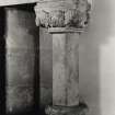
NS 790 940 A fragment of carved, fine grey sandstone, possibly a capital of a pilaster is visible on the left side of the rear of the fireplace of the room called 'The King's Guard Chamber', in the James V palace.
C A-Kelly 1997
NS 7888 9412 About 82m E of where it breaches the earlier wall from the castle to the garden, the upper path along the SW slope of the castle rock cuts a spread of mortar and debris. This extends for almost 100m, and includes bone and oyster shell among mostly modern pottery and glass, with some sherds of green-glazed white gritty and grey gritty ware, continental imported ware and pipe stem fragments of 17th-century type.
NS 7903 9403 Built into the inner face of the NE curtain wall, just above the walkway, just N of The Mint, appears to be a capital of a pilaster, built in upside down.
C A-Kelly 1998
NS79SE 6.01 78996 94035 Palace
NS79SE 6.02 78984 94096 Chapel Royal
NS79SE 6.03 79044 94025 Forework
NS79SE 6.04 79017 94077 Great Hall
NS79SE 6.05 79030 94095 Mint
NS79SE 6.06 78961 94073 The King's Old Buildings
NS79SE 6.07 79068 94007 Outer Defences
NS79SE 6.08 Cancelled See NS79SE 7
NS79SE 6.09 79049 94068 Kitchen Range
NS79SE 6.10 79110 93928 Esplanade
NS79SE 6.11 79050 94038 Governor's House
NS79SE 6.12 79090 93952 Princess Louise's CXI Battalion South African War Memorial
NS79SE 6.13 79123 93983 Bruce Statue
NS79SE 6.14 78954 94116 Sundial
NS79SE 6.15 79234 93937 Married Quarters
NS79SE 6.16 78468 93175 Kings Park
NS79SE 6.17 79064 94043 Regimental Headquarters
NS79SE 6.18 78967 94153 Nether Bailey
See also:
NS79SE 7 78896 93646 King's Knot
NS79SE 21 79261 93808 Argyll's Lodgings
NMRS REFERENCE
NMRS Printroom - Inglis photograph Collection
acc no 1994/90
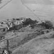
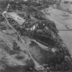
2 prints showing view from King's Knot
1 close view of castle
NATIONAL LIBRARY REFERENCE:
'Master masons of Scotland', Vol I, p.3, 46 and 47
The Castle of Stirling (from catalogue slip)
Is under the charge of the Commissioners of H M Works
The National Library of Scotland holds a series of original drawings (many are coloured) of the Board of Ordnance, relating to the years of the 18th century before and after the Jacobite Revolutions of 1715 and 1745, Reference 'MSS. 1645 - 1652'
The drawings include, from Case or Volume, 1645, the following:
Number Year
Z.2/23 1708 'A Plan of Sterling Castle to scale of 16 Feet to an Inch and a profile of Elphinstone's Tower and French Spur to a scale of 20 Feet to an Inch. Docketted as 'Design by Capt. Drury, Anno 1708.' There are 2 copies.'
Z.2/16 No date Old Plan docketted on back 'Sterling Castle with Design'. There is no scale
Z.2/16 No date Old Plan of 'Sterling Castle' Scale 30 Feet to an Inch. Bears the name of T Drury, Fecit.
Z.2/17 1709/10 'The Royal Apartments in the Palace of Stirling Castle' Docketted on top as 'Ground Floor of the Palace at Stirling Castle' Scale 20 Feet to an Inch, dated 1709/10
Z.2/18 1719 Four Sheets of General Drawings, numbered 1 to 4, of Sterling Castle, 1719, with References. Sheet No 2 shews the Plan of the Great Hall, Section and C, to scale of 10 Feet to and Inch. It is signed by Thos Moore.
Z.2/19 1725 'A Plan of the Town and Castle of Sterling 1725', With References. Scale 250 Feet to an Inch. Bears the name of John Laye. There is also a copy.
Z.2/20 No date Another Plan of the 'Town and Castle of Sterling' to the same scale
Z.2/21 1740 'A Plan of the Town and Castle of Sterling, 1740' WIth References. There are 2 copies, both dated 1740.
Z.2/22 1741 Four sheets of General Drawings of Sterling Castle, numbered 1 to 4. Scale 10 Feet to an Inch. Date 1741.
There is also in Case or Volume, 1650, the following drawing:
Z.46/58 No date 'Sterling Castle. Plan of the Governer's Apartment(s). Scale 12 Feet to an Inch.
SCOTTISH RECORD OFFICE REFERENCE:
Erection of a stone dyke about the garden and repairs to Stirling Castle.
Copy of royal letters
1638 GD 124/11/12
Letter concerning the state of the roof of Stirling Castle. The Privy Council authorised the E. of Mar to have it repaired.
1687 GD 124/11/37
Windows of Stirling Castle. Two fragments of a warrant for the glazing of part of the castle. Sent by the Lord Commissioners of the Treasury to Sir William Bruce, Surveyor General.
1674 GD 1/51/52
Letterhead bears a small cameo motif. Letter from 'Granny' to John Murray.
No date (c.1855) GD 189/2/923
Fire at Stirling Castle in that part known as the Old Palace, in which the celebrated Douglas Room...is situated', newspaper cutting
1855 GD 189/2/1012/3
Description of the Parliament Hall of Stirling Castle. Letter from William Stirling to Sir John Clerk.
1741 GD 18/5013
Report on Stirling Castle. What James Smith has said of Holyrood is even more applicable to Stirling with the addition that the platforms and embrasures are all ruined, the half being all broke down with the flashes of powder and the others rotten, having been made only of fir deals many years ago.
1707 GD 124/15/471
Repair of the roof of Stirling Castle. Letter to the Earl of Mar from the Privy Council. He is authorised to have the roof repaired.
1687 GD 124/11/37
(For James Smith's report on Stirling Castle see under Edinburgh)
1707 GD 124/15/471
Repairs to Stirling Castle. Copy of royal letters.
1638 GD124/11/12
Repair of Stirling Castle. Letter from the Earl of Seafield to the Earl of Mar. He explains that it is difficult to obtain money for repair work.
1700 GD 124/15/207/3
Stirling, St James Fort
A plan for unbuilt fortifications proposed N of Stirling Bridge (NS79SE 2) is held in the National Archive (formerly the Public Record Office. Planned by Major Marlin Beckman in the late 17th century, the proposed fort would have rested on 'the left bank of the Fort' (Dunbar and MacIvor, 1965) the exact location of which is not known. Information from RCAHMS (D.E.), February 2004.
ANTIQ. SOC.
Topographical collection - 3 engravings dating from 18th century
Publication Account (1978)
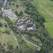
The first mention of the castle at Stirling occurs in the dedication of a chapel there by Alexander I (ESC, 1905, 146). At the end of the thirteenth century it was acknowledged to be one of the premier fortresses in the kingdom, the focal point of much activity during the Wars of Independence. It was the Stewarts, particularly those from James II until VI, who favoured Stirling as a royal residence.
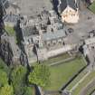
Most of the principal buildings of the castle date from the sixteenth century, although some fourteenth- and fifteenth-century work survives. The fortifications and batteries which form respectively the inner and outer defensive barriers on its south east side date from the eighteenth century (RCAHM, 1963, 42). The Great Hall and the Palace are two buildings which command great interest. Completed by James IV, the Great Hall (also known as Parliament Hall) is a massive structure measuring approximately 126 feet (38m) by thirty-six (Um) and rises to a grand height of early fifty-four feet (16. 46m) (RCAHM, 1963, 42). The interior of the building was greatly mutilated in the eighteenth century when the structure was converted into military barracks, although restoration is currently underway. 'In contrast to the Great Hall, which is perhaps the finest achievement of late-Gothic domestic architecture in Scotland, the palace is an essay in the new manner of the Renaissance' (RCAHM, 1963, 42). Erected in the reign of James V, the Palace on plan was originally a hollow square comprising four ranges of buildings of which only three survive. Among its most noted Renaissance features are the grotesque and human statues which embellish its exterior. The Chapel Royal erected in the reign of James VI also is of some interest as it was one of few ecclesiastical buildings erected in Scotland at this period (RCAHM, 1963, 211).
Information from Scottish Burgh Survey, ‘Historic Stirling: The Archaeological Implications of Development’, (1978).
Publication Account (1985)
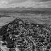
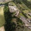
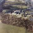
Stirling Castle owed its importance in the medieval period to a combination of a crucial strategic position and a strongly defended natural fortress. Because it lay at the lowest bridging point of the River Forth, it commanded both major north-south and east-west land routes and its possession was vital to anyone seeking military control of eastern Scotland.
Although the site of the castle has probably been occupied more or less continuously since prehistoric times, and is on record as an important royal stronghold from the 12th century, the majority of the surviving remains date from the 16th to the 18th centuries. The late medieval castle lay around the highest part of the hill and comprised a massive curtain wall with square corner towers and a centrally placed twin-towered gatehouse (largely built about 1500). Within the enclosure formed by the curtain wall, there is a magnificent group of royal buildings reflecting the frequent use of the castle as the residence of the Scottish could in late medieval times.Principal among them are the Palace, Great Hall and Chapel Royal. The Great Hall is the ea rliest of these buildings, being contemporary with the curtain wall, and completed in the opening years of the 16th century. In form it is a typical medieval hall but built on the grand scale, outsizing Edward IV's Great Hall at Eltham and Hem), VIII's at Hampton Court. Unfortunately, it was badly mutilated in the 18th century and is now slowly being restored. While the inspiration for the Great Hall looked back to the middle ages the Palace, built only a generation later (between 1540-42), heralds the arrival in Scotland of the Renaissance style of architecture, and is witness to the renewed contacts between Scotland and France at this time. It is remarkable for the treatment of the exterior, particularly the sculpture; the interior, however, has been much altered and all that survives of the original fittings is a series of carved wooden medallions (known as the Stirling Heads) which once decorated the King's presence chamber. The Chapel Royal was built in 1594 for the baptism of Henry, the eldest son ofJames VI, and it is reputed that the best workmen were brought from all over the country to complete the work.
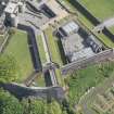
During the later 17th century considerable improvements were made to the north-west defences with the enclosure of the Nether Bailey, and within the castle the King's Old Buildings and the Grand Battery were erected. In the 18th century, following the Act of Union, an extensive programme of works was begun to improve the castle's defences. Between 1708-14 the outer defences were remodelled to take account of advances in artillery, and three large batteries were installed behind a broad ditch, the bottom of which was protected by a caponier (see also Craignethan Castle, no. 32). The castle remained an army barracks until 1958 when it passed into the care of the state, and the HBM (SDD) are now in the process of making good many of the alterations carried out to the castle in the later 18th and 19th centuries.
Information from ‘Exploring Scotland’s Heritage: The Clyde Estuary and Central Region’, (1985).
Excavation (1986)
NS 790 940 A brief excavation took place immediately N of the great hall after pipe-laying work had exposed dense midden deposits. In a small trench, 2.6m NS by 2.0m EW by up to 1.6m deep, the steeply S to N sloping bedrock had been partially levelled up prior to construction of the great hall annexe and the inner castle wall in the mid 16th Century. Above further levelling dumps between the two walls was a thick layer of rubble including two large stone balls, each c 0.45m diameter. The debris may have come from the early chapel, immediately to the W, replaced in 1594. The remainder of the deposits included a well stratified series of 17th to 18th Century bone middens from the great hall kitchens, amongst which was found the finely worked stone head of a bishop.
Sponsor: Historic Buildings and Monuments
J Cannell
Excavation (1987)
In 1987, excavations were carried out by John Cannell in northeast corner of the Upper Square in Stirling Castle where the Chapel Royal joins the Great Hall.
John Cannell 1987
Excavation (6 January 1992 - 13 March 1992)
A programme of fieldwork was concentrated on two areas of the post-medieval defences of the castle in advance of prposed development. Area 1: The Interior of a building variously described as the Cart Shed or Straw Store. Area 2: An extensive area in front of the main 16th century facade and N of the Queen Anne casemates.
Area 1: Excavation Report
After the concrete floor from the interior of the Cart Shed was lifted, a series of soft earth deposits were ultimately removed down to bedrock over most of the area. The finished levels were specified by the required depth from architects' plan, so wherever that level was reached, excavation stopped. The broad phases of activity in this trench can be summarised as: Phase 1: Two apparently independent routes up to castle rock cut in bedrock. Phase 2: Defensive ditch and roadway wall built. Phase 3: Timber building constructed over infilled phase 2 wall and ditch. Phase 4: Straw Store/Cart Shed built. Phase 5: Cart Shed converted by demolition of N wall.
Phase 1
The Castle rock itself is a tightly jointed doleritic sill with pronounced regular bedding planes. Where exposed in Area 1, the bedrock surface showed signs of much weathering and wear (much more pronounced than the bedrock found in Area 2) and apart from efforts to prize sections of the sill apart to create space for Phase 3 timbers, showed sign of particular wear in 2 areas. To the SW of Area 1 two lines of 'wear' apparently evidence of vehicular traffic, were picked up, running down towards the SW. This roadway showed signs of having been levelled up and repaired with mortar rubble, resulting in a full width of 1.6m. Part of an arguably earlier trackway was picked up towards the N of Area1. This took the form of a pronounced gully or rut worn into bedrock, truncated by later ditch and associated wall F.040 and which may well be the southern side of a road, predating the ditch and wall construction of Phase 2.
Phase 2 c 1550-c1670
The S route was retained as main access to the Castle during the period of the pre-Queen Anne rebuilding programme. The creation of the French Spur saw the excavation of a deep ditch to the SE and protecting the main entrance route. Part of the ditch appeared at the NW corner of Area 1, underlying part of the N wall of the Cart Shed. It was cut against bedrock but may well be an enhancement of a natural outcropping. The ditch was tested to a depth of 2m and was not bottomed. A light mortar bonded wall lat across the southern side of the ditch - built directly onto the bedrock. This wall (F.040) was poorly preserved but proved to be 500mm wide and despite being truncated by the N wall of the Cart Shed, ran for a distance of 4.8m.
Phase 3.
The Phase 2 wall was demolished and levelled down to 2 or 3 courses, and its associated ditch was infilled with an homogeneous dump of dark earth and stones. The area was generally levelled up to receive a series of timber pads and post holes, reflecting at least one long wall of a timber building aligned E/W. There were in total 3 positive post holes (F.032, 023, 012) with one possible (F.024) with 2 pads (F.025 and 016). The settings were formed from the rubble infill of a series of crudely excavted areas on the bedrock, following the approximate line of the N edge of the Phase 2 trackway. The post settings were essentially squared voids 200mm by 200mm, and 1.5m apart. There was a possible entrance towards the W edge of the line, between the posts F.025 and F.012, defined by a door post stone (F.019). The role of pads F.025 and more enigmatically F.016 is not clear, and it
may be that the timber settings reflect enclosures rather than roofed structures. In any event, it seems that the Phase 3 timbers were temporary precursors to the Straw Store/Cart Shed which was in place by 1860.
Phase 4
The foundations for the Cart Shed walls were cut against the accumulated floor/occupation surfaces from Phase 3 activity, set within irregular foundation trenches, which varied in width from 150mm to 300mm. The depth of the distinctive shaped foundations also varied- deepening considerably to hit towards the SE, a depth of 1.2m. Once a level footing for the faced masonry was in situ, the floor was laid, characterised by mortar spreads (recycled builders' debris). Then the walls were raised to full height, with an apparent door towards the W end of the N wall. This was reflected by a distinctive recess in the S face of the N wall at this point and an equivalent projection of the N face. This does not admittedly concur with the 1860 plan which shows a centrally placed door in the N wall but no signs of such were revealed in the excavation due to damage in Phase 3.
Phase 5
The present open N wall with squared ashlar pillar was formed by the demolition of the Phase 4 N wall to virtually foundation level and the raising of floor and immediate exterior surfaces by 300mm. This was ultimately concreted over and saw use as a 'garage'.
Conclusion
The significance of the excavation in this area can be summarised as: (1) The identification of late medieval access to the castle truncated by 16th century works. (2) The presence of temporary wooden structures predating mid 19th century cart shed/straw store.
Area 2: Excavation Report
The earliest feature revealed on the site was a cut in the granite bedrock in the NW corner of the trench. The natural cleavage of the rock had been exploited to exaggerate a natural drop or, possibly, in order to create a ditch. The line of the feature respected the early 16th century castle frontage and may be a defensive feature associated with this, or perhaps an earlier phase if this is a raised position.
The excavations uncovered a length of the wall built during the regency of Mary of Guise c1559 (shown on Slezer's 17th century plan). This ran S from the section excavated in the late 1970's.
Presumably there must have been a certain amount of landfill between this wall and the early 16th century frontage, but these deposits were not reached before the required depth of excavation.
The Mary of Guise wall was used as the foundation for the battery defences built between 1708 and 1714 during the reign of Queen Anne. It seems likely that the battery wall and casemates were built almost free standing - certainly no foundation trenches were noted. The ramp wall leading down into the area was also built in this phase. Once the lower courses of these structures were laid, material was dumped against them to secure them and to raise the level of the area in general.
The original base levels of the ramp and casemate walls was indicated by the quoins uncovered reflecting a ground surface approximately 1.5m below that of the modern one.
On the 1725 plan of Stirling, the ramp wall is not shown, although the structural details are exactly the same as those of the casemate corners. However this plan shows the battery wall and the casemate extending further than they do today. There is evidence for this on the site - although not for a 2-floor barrack. A well-constructed mortared square plinth F127 was found which was inline with the casemate frontage and exactly the width of an arch from the surviving casemates. The lack of demolished wall, signs of bonding to the battery wall or remnants of vaulting suggests that the end structure was for a different purpose - possibly an outhouse for large pieces of equipment such as artillery or carts.
It is not known for how long the Queen Anne battery and casemates were used in their original form, but at some point (or points) before 1860 the layout of the area radically changed. The end casemate was demolished and the ramp wall was foreshortened. A long subdivided lean-to (three foundation piles for which were excavated) was placed against the early 16th century castle frontage and another built where the end casemate stood. The whole ground level for the area was raised by approximately 1m including within the casemates. The ramp down into the area was raised and formed by the considerable dumping of rubble given a smoother surface by the use of mortar. Cobbles/sets may also have been used over this.
However, by the late 1860's the lean-to against the 16th century frontage had been demolished, the casemates were contractors stores and the lean-to on the site of the demolished end casemate was used as an engine house. This structure was used until 1991 when it was demolished. The access routes and general ground levels in the area remained much the same as in the 19th century, the only real changes being the laying of electricity and telephone cables and the late 1970's excavations.
Thus, despite the slightly unpromising nature of the area to then be excavated, features dating from the late-medieval period onwards were uncovered, the history of the use of the Mary of Guise and Queen Anne period defences elucidated the survival of early 18th century deposits (and their contents) confirmed.
G Ewart 1992
Sponsor: Historic Scotland
Kirkdale Archaeology
Excavation (2 March 1993 - 7 May 1993)
NS 790 940 A series of small-scale excavations and watching briefs were completed between March and May 1993 as part of the major ongoing programme of rebuilding and upgrading at the Castle. The results of this most recent fieldwork can be summarised in terms of the four areas of the Castle effected.
1. The Overport Battery Casemates and Trance (part of the new restaurant development)
During the removal of 19th and 20th-century levelling deposits. A remnant of a defensive line, predating the Queen Anne works, was discovered in Casemate 1
2. Guard Room Square
Beneath elements of the southern Queen Anne defences, slight evidence of the earlier southern access route on to the site was traced in the form of worn and weathered bedrock.
3. The Lower Square
During the excavation of a series of pipe and service trenches, water conduits - both for drainage and water supply, were found, the earliest of which dated to the Queen Anne rebuilding programme. Also, some crude stonework with associated midden deposits, were discovered towards the SE of the Great Hall. These features are provisionally dated to the late 15th/early 16th century and represent levelling up, whether casual or deliberate, over the steeply shelving bedrock to the E of the Great Hall, down to the
North Gate.
4. The Queen Anne Battery Casemates
The interiors of four of these chambers were cleared of 19th and 20th-century infill, down to primary (early 18th century) occupation levels. Evidence of wooden floors and large squared hearths in each was found, all of which were later obscured by the raising of the floors throughout the range towards the middle of the 19th century.
G Ewart
Sponsor: Historic Scotland
Kirkdale Archaeology
Excavation (4 October 1993 - 29 October 1993)
A series of excavations were carried out by Kirkdale Archaeology in October 1993. Extensive excavations took place on the West side of the Great Hall, including the area of the Upper Square and Transe. These excavations reaveled evidence for an structure, possibly a Chapel.
Excavations were also carried out in advance of a services being laid in the area to the Northwest of the Casemates in the Queen Anne Garden.
G Ewart 1993
Sponsor: Historic Scotland
Kirkdale Archaeology
Excavation (19 December 1994 - 4 October 1995)
NS 7990 940 In advance of the re-roofing of the Chapel Royal, a programme of excavation was mounted over December and January of 1994-5 in the Upper Square and Douglas Gardens within the Castle.
The Upper Square: Two trenches were opened in the Upper Square. The earliest structure found was the SE corner of a stone building. This was formed by a SW-NE wall and its return, extending NW. The SW corner of the same building was seen in the 1994 excavation inside the Chapel Royal. This structure was aligned NE-SW. It measured c13.1m NE-SW and was at least 4m wide, although the northern limit was not seen.
A large amount of charcoal, ash and metalworking debris was recovered in the upper layers associated with the usage of this building, perhaps suggesting that the latest occupation was industrial. However, it may be that the building was originally an earlier version of the Castle Chapel, predating the 15th century Chapel.
The second phase of activity involved the construction of the 15th century Chapel, parts of which were also revealed throughout the trench, showing it to be at least 29m long and some 9m wide, aligned ENE-WSW.
The discovery of drystone structures within the levelling material prior to the construction of the 15th century Chapel suggest that it had two building phases, the first involving a crypt which was filled in at a later date to stabilise the masonry above, probably part of the documented 1505 repairs.
The other major structure studied in the Upper Square was the present Chapel Royal, known to date to 1594. A complete pottery vessel was found standing upright in the construction trench for the S wall of the Chapel. This pot was almost identical to vessels recovered from beneath the floor of Innerpeffray Church in Perthshire, these examples having been dated to the period 1508-1650.
There were at least eighteen different masons-marks noted on and around the string course of the S Chapel wall.
The Douglas Gardens: A total of six trenches were opened in the Douglas Gardens. The earliest remains comprised part of a wall aligned SE-NW, comparable to structures in the Upper Square, and finds recovered from this period of activity seemed to indicate an early-mid 14th century date for its demolition.
Built on top of this early wall was a retaining wall with a bank behind (to the W of) it. This revetment may have incorporated part of the earlier wall, which had by this stage been partially demolished. The bank seems to have stood to a height of c1.3m, and finds from its surface indicate late 15th-early 16th century activity.
G Ewart and A Radley 1995
Sponsor: Historic Scotland
Kirkdale Archaeology
NS 790 940 Fieldwork during summer 1995 concentrated mainly on excavation in the Upper Square, over and immediately adjacent to the late 18th-early 19th century cistern, which lies to the W of the Great Hall Transe. Further work comprised the monitoring of the excavation of a series of 11 small pits to receive information boards. One of these holes, located in the Queen Anne Gardens, revealed a lime-mortared wall, possibly that shown on the 17th century plan by Slezer. The remaining holes revealed little of archaeological significance, aside from levelling material.
The earliest features revealed in the main excavation comprised a series of occupation surfaces, truncated during the construction of the cistern. These deposits were only revealed in a narrow strip, on average 1m in width, but represent a complex series of early medieval occupation horizons. The medieval occupation is most obviously characterised by a hearth-site, which in turn probably relates to a series of crude structural timber settings, and floor surfaces. Overlying this sequence of deposits were tip-lines and courtyard levels associated with the construction, occupation and demolition of the 15th century Chapel Royal.
The Transe wall was built in two phases, the upper section relating to the vaulting-over of the Transe itself during the later 16th century.
The cistern was revealed in its entirety, showing it to be 15.5m long N-S by 4.25m wide, and of high quality sandstone construction. It had been much altered and repaired since its original construction, affecting both its supply and capacity, and access to it. The capacity of the tank was c120m3 (c26,400 gallons), and it was intended to provide water in the event of fire.
G Ewart and P Sharman 1995
Sponsor: Historic Scotland
Kirkdale Archaeology
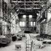
NS 790 940 Excavation within the Great Hall comprised the recording of a series of cross-walls dating from the later 18th century conversion of the Hall to barrack accomodation. These walls sub-divided the ground floor into four chambers, with two staircases leading to upper floors. The walls themselves were of massive lime-mortar construction, and two of them featured flues serving fireplaces within the vaulted basement.
The Great Hall floor was recorded in detail, and evidence of both its original pattern and its subsequent damage to receive later floor surfaces and modifications to the internal arrangement of the Hall was noted. It appears that the pattern of floor slabs reflected some sub-divisions within the Hall as completed during the early years of the 16th century.
In addition, two trenches were excavated in advance of the re-roofing of the Great Hall. Of these trenches, one lay to the S of the Hall, and contained considerable deposits of charcoal, alongside pottery of 14th and 15th century type. The second trench was cut at the base of the E wall of the Palace. The excavation of this trench was curtailed by the presence of modern services.
G Ewart and A Radley 1995.
Sponsor: Historic Scotland
Kirkdale Archaeology
Excavation (30 November 1994 - January 1995)
A total of six trenches were opened in the Douglas Gardens. The earliest remains comprised part of a wall aligned SE-NW, comparable to structures in the Upper Square, and finds recovered from this period of activity seemed to indicate an early-mid 14th century date for its demolition.
Built on top of this early wall was a retaining wall with a bank behind (to the W of) it. This revetment may have incorporated part of the earlier wall, which had by this stage been partially demolished. The bank seems to have stood to a height of c1.3m, and finds from its surface indicate late 15th-early 16th century activity.
Sponsor: HS
G Ewart 1994
Kirkdale Archaeology
Excavation (November 1996 - 23 June 1997)
NS 790 940 A series of excavations were undertaken at Stirling Castle by Kirkdale Archaeology during 1996-7, as part of the ongoing refurbishments to the buildings in the Upper and Lower Squares.
W wall of the Great Hall
Three 1sqm holes were opened against the W side of the Great Hall, on top of the transe vault. Surviving patches of harling on the wall of the Great Hall provided samples for analysis. The top of the transe had been revealed before in excavations.
Army kitchens
Two small rooms were investigated in the E end of the building used as the army kitchens between the S end of the King's Old Buildings and the NW corner of the palace. The aim was to reduce the levels in these rooms by approximately 0.8m in order to provide an access route from the palace porch via a currently blocked doorway into the range. The grey stone paving slabs were removed by a Historic Scotland squad.
It would seem that up to almost 1m of deposits survive below the floor of the army kitchen range, including important information about the medieval castle. The presence of graves indicates that the shell of this building may, despite its later appearance, be that of the other chapel at the castle, possibly that used for private worship by the monarchy, situated as it is between the King's Old Buildings and what is thought to be the site of the queen's lodgings.
The Transe
An excavation was undertaken within the transe on the W side of the Great Hall, with the intention of excavating to bedrock and recording the structure itself. The uncovering of setts in the S part of the transe meant that the brief was changed in order to leave the surface in situ.
The features in the transe fell into seven basic phases, the first one being that which encompassed the worn surface of the bedrock and the surviving patches of surfaces earlier than the transe wall, giving some idea of what the ground surface was like when the Great Hall was constructed at the end of the 15th century. It may be that the lower doors and the window were visible giving an added impression of height to the Hall. It is possible that the W transe wall was built at the same time as the Great Hall, in order to support the lean-to roof which ran along its W side. No evidence was found for the method of access to the main door of the Great Hall. It is assumed that a bridge across the unroofed transe to the door is the most likely solution, although the Chapel Royal prior to the upstanding building would have blocked this access somewhat. The surface of the transe floor yielded no evidence for a staircase against the face of the Hall.
The fourth phase was that of the E-W transe added to the N side of the Great Hall, with a lean-to storey on top, presumably done at some point in the 16th century. The uncertainty of the structural sequence at the N end of the transe possibly reflects a complicated sequence of construction and adaptation of upstanding structures in order to support the range and/or the later vestibule built to connect the Great Hall and the Chapel Royal in the 17th century. There is evidence of a blocked door in the return of the Great Hall and the vestibule in the Upper Square, a feature which would probably have been reflected structurally in the transe. The vaulting of the transe must have happened prior to this and almost certainly before the new Chapel Royal was built at the end of the 16th century, because the chapel takes account of the raised level of the Upper Square.
Many of the features in the transe belong to phase 6, the period of the army's occupation of the castle. The doorways into the Hall were blocked up and turned into windows, new doors were inserted, cobbled and flagged surfaces laid, services introduced and so on, reflecting the need to turn a royal residence into a functioning garrison. Features belonging to the 20th century reflect the patching of damage done during the previous phase and the use of the castle as a heritage resource.
Area between the Upper and Lower Squares
Historic Scotland wished to adjust the shape of the ramped access between the Upper and Lower Squares to take account of the threshold levels of the doors into the transe and Great Hall basement respectively which had previously been exposed by archaeological excavation. Kirkdale Archaeology were engaged to reduce the existing level to provide a base for a new road surface. The bedrock proved to be generally too high for the proposed base level and the whole area was cleared to bedrock rather than the levels initially required.
During the excavation, it was decided to reroute the existing services along the line of a storm drain running parallel to the E face of the palace. The previous cut was reopened and adapted, during which several archaeological features were noted.
A narrow trench (2-3m wide) was initially opened along the N face of the palace before being ultimately widened to meet the S face of the Upper Square retaining wall and below the bridge between palace and Great Hall. The earliest features encountered were interpreted as an oven and a hearth, and were dated to the 15th century. These were overlain with a crudely metalled surface dated to the 16th century, although it was unclear whether this deposit was earlier or later than the palace building.
Monitoring of the re-excavation of a storm drain trench
The most striking feature identified in a second trench was the massive wall base. This had been previously recorded and its line is preserved in the pattern of setts of the present courtyard surface as with the lines of early chapel walls in the Upper Square. This feature seems too solidly built to be merely a domestic structure and, if the N-S wall is the foundation platform for the palace, is most likely to be an integral part of the Fair Front or the earlier defences.
A midden deposit was of interest because it did not appear to be specifically domestic in origin but perhaps more likely to be associated with stable or byre waste.
The evidence clearly confirms surprisingly high archaeological potential within the Lower and Upper Squares where the natural profile of the bedrock can preserve relatively deep deposits of occupation material together with structural remains.
G Ewart, A Radley, P Sharman and J Triscott 1997
Sponsor: Historic Scotland
Kirkdale Archaeology
Watching Brief (27 November 2000)
In November 2000 Kirkdale Archaeology undertook a short Watching Brief at Stirling Castle focused on the Army Kitchen.
G Ewart 2000
Sponsor: Historic Scotland
Kirkdale Archaeology
Dendrochronology (1 January 2008)
Dendrochronological analysis of 133 oak timbers and 58 pine timbers from Stirling Castle. Six distinct episodes of building activity were identified. This was a report produced as part of the work at Stirling Castle begun in the mid-2000s, which culminated in the publication of 'With Thy Towers High: The Archaeology of Stirling Castle and Palace' (Historic Scotland, Edinburgh, 2015).
Information from OASIS ID: kirkdale1-504411 (A Crone) 2008
Desk Based Assessment (1 January 2008)
The report is an attempt to make sense of the relationship between one hill (Stirling Castle Rock), its surroundings, some monarchs and the monarchs’ successors as controllers of the hill and the landscape, successors who include the British army and (more recently) Historic Scotland, Stirling Golf Club and ‘the tourist industry’. The report builds on earlier work but time has precluded any deep examination of the medieval evidence beyond what is already published. And it has also limited examination of the period since about 1900. This was a report produced as part of the work at Stirling Castle begun in the mid-2000s, which culminated in the publication of 'With Thy Towers High: The Archaeology of Stirling Castle and Palace' (Historic Scotland, Edinburgh, 2015).
Information from OASIS ID: kirkdale1-504436 (J Harrison) 2008
Desk Based Assessment (1 January 2008)
A general discussion of the evidence produced as a result of the work at Stirling Castle begun in the mid-2000s, which culminated in the publication of 'With Thy Towers High: The Archaeology of Stirling Castle and Palace' (Historic Scotland, Edinburgh, 2015). A general discussion of the evidence produced as a result of the work at Stirling Castle begun in the mid-2000s, which culminated in the publication of 'With Thy Towers High: The Archaeology of Stirling Castle and Palace' (Historic Scotland, Edinburgh, 2015).
Information from OASIS ID: kirkdale1-504429 (G Ewart) 2008
Artefact Analysis (1 January 2008)
The large assemblage includes the first prehistoric finds found at Stirling Castle, and a range of medieval to modern material. The 17th-century midden layers are particularly rich in finds.
There are also deposits of 13th and 14th-century midden and pockets of 16th-century midden as well as dumps of modern material, though upper layers are particularly disturbed by a profusion of Victorian and later service trenches. The most unusual find is an in situ fragment of a brick floor of probable early 16th-century date is associated with industrial activity.
Information from OASIS Id: kirkdale1-504423 (J Franklin) 2008
Project (3 March 2008 - 9 December 2009)
SCPP: Stirling Castle Palace Project
A variety of archaeological work was carried out between 2008 and 2009 by Kirkdale Archaeology under the framework of the Stirling Castle Palace project. This included work on the Palace, Kings Old Buildings, Govenor's Kitchen, Princes Tower, and Douglas Gardens and involved excavations, watching briefs, and standing building recordings.
Measured Survey (April 2010 - June 2010)
NS 7900 9400 A proportion of this very large group of stones was given a very brief survey during April–June 2010, before being cleaned and placed in storage. The stones were removed during work on the King’s Hall at Stirling Castle, and many were recorded in an illustrated catalogue by Nick Bridgland. In such a large collection it is not surprising to find much duplicated material, especially, in this case, corbels. Other pieces included water drainage troughs and saddles, an elaborate section of a window sill, window mullions, and a fragment of a miniature ribbed vault, probably from inside a small canopy.
This listing and other inventories of carved stones at Historic Scotland’s properties in care are held by Historic Scotland’s Collections Unit. For further information please contact hs.collections@scotland.gsi.gov.uk
Funder: Historic Scotland
Archetype, 2010
Excavation (1 March 2010 - 10 February 2011)
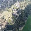
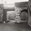
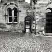
NS 7906 9404 (centred on) A programme of archaeological work was undertaken 1 March 2010–10 February 2011 as part of improvement work being undertaken in the Guard House Square. The work focused on the demolition of the Straw Store and construction of a new ticket office.
Guard House Square represents the main entrance to the Castle within the outer defences of 1714. It was originally built as an open square, with a defensive wall to the S along the cliff edge and to the E against a rock cut ditch, with a further ditch and inner wall to the N and W separating this area from the rest of the castle. Buildings were then built along its edges, with a Gun Shed built against its S wall by 1806. This was demolished and replaced by the Cart Shed (still standing) by 1858. Small ancillary structures built against the Cart Shed’s E wall were then replaced by the Straw Store, which is present by 1898. The original Straw Store occupied the N end of the E side of the Cart Shed, but in the 1950s an extension was appended to the S, between the Straw Store and the S wall of the castle. Other structures in square include a stables block and coach house just to the E of the Straw Store built against the E wall and a guard room in the NE corner.
A plan of 1708 shows the area immediately prior to the construction of the defences of 1714. This indicates that while the walls to the E and S are new, those to N and W follow similar alignments to the earlier (mid-16th-century) defences. A pyramidal spur projects out from these earlier defences, occupying the NE corner of the current square, with a probable ditch running around its S side. The entrance road to the castle is shown swinging around to the S of this ditch, running along the cliff edge to the S, and swinging back around to the N, with its projected path running right through the Straw Store and Cart Shed.
The following describes the sequence of fieldwork in terms of a series of stages, each reflecting a change in the focus and character of the work.
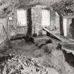
Stage 1 (1–19 March 2010) – Excavation and standing building recording Trench 1 was excavated against the E side of the Straw Store. Evidence was found for one of the ancillary structures built against the Cart Shed before the Straw Store, and a sequence of dumped, probable levelling layers was excavated, all post-dated or were contemporary with the 1714 S wall. A detailed drawn, photographic and written record was made of the external (N and E) walls of the Straw Store.
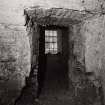
Stage 2 (23 November 2010–13 January 2011) – Standing building recording and watching brief A rapid photographic and written survey, using annotated sketches rather than formal drawings, was made of the inside of the Straw Store. This revealed details such as the partial survival of a window in the E wall of the Cart Shed (matching a surviving one in its W wall), and the blocking of a fireplace in the S wall of the Straw Store. An intermittent watching brief was then maintained during the demolition of the Straw Store. Details of the Straw Store’s construction, such as the use of massive blocks for aperture surrounds, and the incorporation of a cast iron chimney flue in its S wall were recorded.
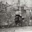
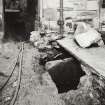
Stage 3 (14–27 January 2011) – Excavation During this stage Trench 2, which occupied the footprint of the mostly demolished Straw Store was excavated. The wall of the ancillary structure split this trench into two halves. To the S post-1714 soil dumps were encountered. To the N infill surrounded exposed bedrock. The removal of the infill revealed fragmentary deposits that incorporated a wall line, running roughly NW–SE, with a probable ditch edge on its N side, and bedrock close to the surface to its S. The N face of this wall had been covered by a fine lime plaster at some stage.
Stage 4 (28 January–3 February 2011) – Excavation A deeper service track was excavated across the N end of the site, just to the E of the exposed section of wall. This exposed the continuation of this wall to the E, albeit at a lower height, which led to a request to lower the whole E side of the N end of Trench 2. The removal of later levelling deposits allowed the services to be placed without causing disturbance to the wall. A third trench was also opened up to the E of the S end of Trench 1 against the S wall of the castle, to accommodate a manhole. The trench contained services, deep infill deposits, which post-dated the castle wall, and revealed the drop in bedrock to the S and E.
Stage 5 (4–10 February 2011) – Excavation A service track (Trench 4) was dug N for 18.5m across the Guard House Square from the N end of Trench 3 to an existing manhole at the SE corner of the Guard House. The damaged remains of masonry, possibly the remains of the Spur, were recorded on a northward sloping bedrock terrace. A 0.3m drop at the S end of the bedrock may represent the N edge of the putative ditch found in Trench 2, and suggesting that the ditch was c7m wide.
Archive: RCAHMS (intended)
Funder: Historic Scotland
Kirkdale Archaeology, 2011
OASIS Id: kirkdale1-504428
Watching Brief (11 February 2011)
NS 7916 9395 (centred on) A watching brief was carried out on 11 February 2011 during the excavation of a trench for a fibre optic cable. Although nothing of archaeological interest was recorded, the area remains of interest due to its proximity to the castle and the fact that the remains of post-medieval and potentially medieval buildings can be seen preserved, as façades, in some of the nearby path and road boundary walls.
Archive: RCAHMS (intended)
Funder: Historic Scotland
Kirkdale Archaeology, 2011
Watching Brief (31 May 2011 - 14 June 2011)
NS 7905 9401 (centred on) A watching brief was carried out 31 May–14 June 2011 during the installation of five information boards. In order to minimise impact to the potentially important historical surfaces discovered in some of the trenches, where practical, the current sign bases were reused for the new boards.
Archive: RCAHMS (intended)
Funder: Historic Scotland
Kirkdale Archaeology, 2011
Information also reported in Oasis (kirkdale1-123796) 23 April 2012
Watching Brief (11 December 2012 - 12 December 2012)
NS 7922 9387 A watching brief was carried out, 11–12 December 2012, during the excavation of two trenches on the approach road to Stirling Castle, which runs up the SE side of the Esplanade. The trenches were dug to allow the replacement of the traffic bollards. No finds or features of archaeological significance were recorded.
Archive: RCAHMS (intended)
Funder: Historic Scotland
Paul Fox, Kirkdale Archaeology, 2013
(Source: DES)
OASIS ID: kirkdale1-311448
Excavation (3 September 2012 - 23 October 2012)
Under the terms of its PIC call-off contract with Historic Scotland, Kirkdale Archaeology was asked to undertake an archaeological watching brief during the installation of new spotlights at Stirling Castle (Fig.1). This comprised the direct replacement of in situ relict lights. The existing spotlights consisted of a metal housing with an internal light fitting, each light joined to the next by electrical cable. These housings were susceptible to water penetration and many were shown to be full of water (therefore the lights had failed).
The watching brief has shown that despite massive disturbance in terms of services having been installed, mainly in the 19th and 20th centuries, there are still relict remains of historic levelling layers, albeit in a truncated form. These layers could be seen around the N and E sides of James V’s Palace, and along the E front of the King’s Old Building. Further areas of interest were flagged up in the trenches on the ramp on the SW and SE of the Forework entrance arch, where historic infilling could seen and, in the case of Trench 19, a possibly pre- southern outworks dressing of the bedrock was noted. Stirling Castle retains high archaeological potential, and watching briefs like this one continue to inform our knowledge of its developmental sequence.
G Ewart 2012
Sponsor: Historic Scotland
Kirkdale Archaeology
Watching Brief (11 February 2014 - 14 February 2014)
NS 7914 9394 A watching brief was maintained, 11–14 February 2014, during the excavation of two trenches on the esplanade of Stirling Castle, one for the footings of a new ticket office and the other for a new bicycle rack, both located towards the E side of the esplanade, immediately to the NE of the E boundary wall. The deposits revealed suggested that the ‘natural’ approach to the castle lay towards the NE side of both trenches. The sloping profile of the natural bedrock and till appeared to define the SW side of the route, the profile now largely ‘fossilised’ in the present cobbled road up the to the site.
Archive: RCAHMS (intended)
Funder: Historic Scotland
John Godbert – Kirkdale Archaeology
(Source: DES)
Excavation (10 November 2014 - 14 November 2014)
A watching brief was maintained during the excavation of two trenches to install footings for handrail uprights serving the wall walk stairs to the northeast and southwest of the Douglas Gardens. Surfaces and stone slabs of unknown date revealed in the trenches were left undisturbed and not investigated, while the areas of excavation were adjusted to avoid any further disturbance.
At the same time, a watching brief was maintained during turf removal at the Ladies Lookout. The Ladies Lookout was extensively excavated by Kirkdale Archaeology during the SPARC project from 2003 - 2005. No additional archaeological features were found during the turf removal.
Paul Fox 2014
Sponsor: HS
Kirkdale Archaeology
Note (11 March 2016 - 18 May 2016)
Stirling Castle occupies a commanding vantage point in the middle of the Forth Valley and is assumed to have been an early medieval caput, though no trace of earlier fortifications or occupation have been discovered beneath the castle itself. Angus Graham correlated Stirling Rock with urbs Giudi mentioned by Bede (1959), and this identification has been pursued more recently by Leslie Alcock (1981). Though the correlation is not necessarily universally accepted, in all probability Stirling Rock is the site of an early medieval fortification, and, like the Castle Rock in Edinburgh, is likely to have been occupied much earlier.
Information from An Atlas of Hillforts of Great Britain and Ireland – 18 May 2016. Atlas of Hillforts SC4228
Standing Building Recording (16 November 2016 - 24 August 2017)
NS 7900 9403 (centred on) A programme of standing building recording was undertaken, 16 November 2016 – 24 August 2017, on the roof of the Palace at Stirling Castle ahead of repair work to chimneys. It had been established that three of the chimneys were in such a poor state of repair that they would have to be partially taken down and rebuilt. A detailed photographic record was made of each chimney, and at least two sides (and usually all four sides) were drawn and a plan made of the chimney head. Fourteen chimneys were recorded in detail.
Traces were seen of crowsteps within the uppermost reaches of the E range, suggesting the substantial survival of a pre-palace structure up to the roof line under much of the E range.
Archive: NRHE (intended)
Funder: Historic Environment Scotland
David Murray – Kirkdale Archaeology
(Source: DES, Volume 18)
Standing Building Recording (23 August 2017)
NS 7898 9407 Standing building recording was undertaken, on 23 August 2017, on a section of the lower external eastern façade of the King’s Old Buildings. The façade contained a window which was to be removed during conversion into a doorway.
This is a complex structure which been subject to considerable modification over the last five centuries. The insertion of an additional floor required significant alteration to floor levels and subsequently to the external façades. The fire in the N quarter led to a massive rebuild and it is here that we see the introduction of the distinctive roll-moulded and chamfered surrounds with pecking. It would appear that the introduction of this style of aperture led to the replacement of the door and window surrounds at ground floor level within the portion of the building which includes the area under examination.
Archive: NRHE (intended)
Funder: Historic Environment Scotland
Paul Fox – Kirkdale Archaeology
(Source: DES, Volume 18)
Watching Brief (21 February 2017 - 24 February 2017)
NS 7902 9396 and NS 7903 9402 A watching brief was maintained and excavation undertaken, 21–24 February 2017, during small scale excavation work within the Queen Anne Garden. This is a level area, with a raised terrace at its N end occupied by grass and flower beds. The excavation in the SW corner of the garden (NS 7902 9396) showed evidence for bedding material for cobbles, with no dating evidence beyond the fact that they post-date the stairs, which are presumed to be early 18th century.
Examination of the masonry surrounding the five test pits (NS 7903 9402) suggests that none of it dates to the 16th-century construction of the nearby wall and tower, and is unlikely to predate the late 17th-century siege, and may in fact reflect even later reworking.
Archive: NRHE (intended)
Funder: Historic Environment Scotland
David Murray – Kirkdale Archaeology
(Source: DES, Volume 18)
Ground Penetrating Radar (30 January 2017 - 31 January 2017)
NS 7900 9400 (NS79SE 6) Three areas within Stirling Castle were investigated, 30–31 January 2017, with ground penetrating radar (GPR) as part of a wider evaluation of the castle as part of a television programme. The primary area surveyed was the Douglas Garden, with smaller surveys undertaken within the Upper Square and the Queen Anne Gardens.
Douglas Garden occupies the highest point of the castle rock and as such has potential for evidence of an earlier castle, and may also contain other structures and possibly remnants of earlier garden features. A small survey (c12 x 10m) was carried out in the SW corner of the Upper Square.
This survey aimed to identify possible remains associated with an early chapel. A further small survey (c30 x 7m) was also carried out in the NW corner of the Queen Anne Garden, but this had to be curtailed due to adverse weather. The GPR results from Douglas Garden were dominated by responses from modern paths and services. A very well defined linear anomaly and apparently associated rectangular response were detected in the centre of the survey area, possibly indicating structural remains. However, these anomalies are only 0.20–0.45m below the surface suggesting they may have, at least in part, a modern origin such as a path. However, they do mark a clear divide in the nature of response across the area with weaker reflections being recorded in the W, suggesting the possible limits of the historic gardens. Within this western area possible postholes and associated trends have been noted which could be indicative of an earlier castle structure, but such an interpretation is extremely cautious.
The data from the Upper Square are dominated by responses from a surface drainage channel, sunken spotlights and buried services. Unfortunately, given the strong nature of these responses, it is likely that weaker responses from archaeological features, if present, were being masked. It is also possible that, given the postulated structural remains lie below cobbles and above bedrock, there is insufficient contrast to adequately detect potential archaeologically significant remains.
The data collected from the Queen Anne Garden was dominated by a broad linear anomaly, assumed to be due to a drain or similar feature.
Archive: Rose Geophysical Consultants
Funder: Windfall Films
Susan Ovenden – Rose Geophysical Consultants
(Source: DES, Volume 18)
Watching Brief (November 2018)
A watching brief was undertaken in November 2018 in Stirling Castle by CFA Archaeology Ltd.
The monitored excavation was 50m long and 0.3m wide. The cable trench was only excavated within the topsoil throughout, with the new cable laid at a variety of depths ranging from 0.1m to 0.3m deep.
No archaeological remains were uncovered.
Information from Bethan Gray, (CFA Archaeology), February 2019
OASIS ID: cfaarcha1-335383
Watching Brief (11 February 2020 - 13 February 2020)
An archaeological watching brief was required during works to re-excavate cable ducts for the floodlighting within Queen Anne Gardens, Stirling Castle. Four trenches were excavated. Two trenches were excavated through the flowerbeds and along the line of existing electrical cable trenches and were within the topsoil of the flower beds. No features were noted. The third trench was dug to 0.7m down against the inside face of the revetting wall for the upper terrace. Within the backfillof the previous cable trench here some animal bone fragments were recovered and are most likely general kitchen waste mixed in the topsoil and re-deposited during the initial cable trench excavation. A fourth trench was dug, running approximately east-west through the lawn and only still within the topsoil. No finds or features were noted.
Information from OASIS ID: cfaarcha1-435454 (G Carruthers) 2020
Watching Brief (19 November 2020)
An archaeological watching brief was conducted by CFA Archaeology Ltd on the 19th of November 2020. During the excavation of three trial pits above the Queen Anne Casemates, Stirling Castle, Stirling to investigate the make-up and depth of existing ground to inform drainage improvements works. Excavations reached a maximum depth of 0.72m, encountering a modern level of concrete and bitumen tanking at this depth.
No significant archaeological features or deposits were observed or disturbed.
Information from Oliver Rusk, (CFA Archaeology Ltd), November 2020
OASIS ID: cfaarcha1-407496
Watching Brief (21 February 2023)
NS 78971 94045 The archaeological Watching Brief took place. A 6.75 by 0.50m trench was excavated at Ladies’ Lookout and a 5.70 by 0.50m trench was excavated within the Esplanade. Excavation for the planting of new yew vegetation within Stirling Castle revealed a series of redeposited topsoil fills. The area along Ladies’ Lookout had been extensively excavated under archaeological conditions by Kirkdale Archaeology under the framework of the Stirling Castle Palace Archaeological and Historical Research project (2003-2006). Further works during this watching brief resulting in the recovery of SF01, a 17th century white clay pipe bowl. No further archaeological remains were identified. Excavation within the Esplanade revealed a series of fills and no archaeological remains were identified.
Information from S. Morris – AOC Archaeology Group, 2023.
OASIS ID: aocarcha1-513395
Watching Brief (3 September 2024 - 5 September 2024)
NS 79020 94020 An archaeological watching brief was undertaken during the uplift of the modern paving slabs in the Prince’s Walk, a raised walkway behind the Forework Wall, leading from the Queen's bedchamber in the Palace to the Prince's Towers. The small area that was investigated within the porch of Prince’s Walk demonstrated no evidence of unknown archaeology. This was in part due to the restrictions of the area and the depth of excavation. However, the exterior area of the Prince’s Walk highlighted the possible alterations the area may have undergone, with a minimum of two additional surfaces demonstrating that alterations have been made to the walkway. Due to Stirling Castle's significance to the historical record, it is recommended that further excavation of a small test pit be conducted to determine the nature and extent of alterations made to Stirling Castle by the military before it came under the care of Historic Environment Scotland
Information from S Swann – AOC Archaeology Group
OASIS ID: aocarcha1-527837

