
Antonine Wall, Croy Hill Roman Fortlet


Fortlet (Roman)
Site Name Antonine Wall, Croy Hill Roman Fortlet
Classification Fortlet (Roman)
Canmore ID 45895
Site Number NS77NW 29
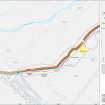
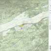
NGR NS 7323 7646
Datum OSGB36 - NGR
Permalink http://canmore.org.uk/site/45895


- Council North Lanarkshire
- Parish Cumbernauld
- Former Region Strathclyde
- Former District Cumbernauld And Kilsyth
- Former County Dunbartonshire
NS77NW 29 7323 7646.
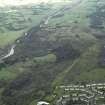
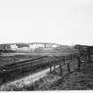
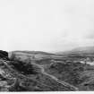
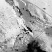
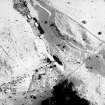
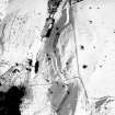
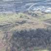
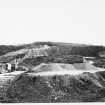
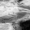
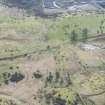
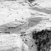
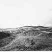
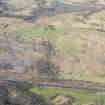
(NS 7323 7646) Excavations in 1977/78 in the vicinity of Croy Hill Fort (see NS77NW 10) revealed a fortlet c.80m west of the fort on a small rectangular plateau.
Rectangular, with the Antonine Wall forming its north boundary, it measured internally 22m N-S by 18.5m E-W within a 2.7m wide turf-cheeked and cobble based rampart. A rock-cut surrounding ditch 3.5m wide by 1.1m deep was on the west side. The rampart, which was separated from the ditch by an 8.0m wide berm, was slighted around the south side, but was shown to be of one build with the Antonine Wall.
W S Hanson 1978; 1979; R Goodburn 1978
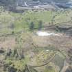
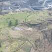
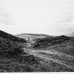
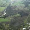
There is no surface evidence of the fortlet on the level, grass-covered plateau although the outline of the back- filled excavation trenches (3) can still be discerned.
Surveyed at 1:2500.
Visited by OS (MJF) 23 May 1980
Listed.
RCAHMS 1982
The internal measurements of this fortlet were c.18.5m from E to W and c.22m from S to N. A turf rampart with stone base plus a ditch, contemporaneous with the Antonine Wall, provided its defence. The peculiarity of the route followed by the ditch and the off-centre position of the S gate seem to have been the result of uninterrupted rock lying immediately below the surface.
Anne S Robertson/lawrence Keppie 2001.
Trial Trench (1977 - 1978)
(NS 7323 7646) Excavations in 1977/78 in the vicinity of Croy Hill Fort (see NS77NW 10) revealed a fortlet c.80m west of the fort on a small rectangular plateau.
Rectangular, with the Antonine Wall forming its north boundary, it measured internally 22m N-S by 18.5m E-W within a 2.7m wide turf-cheeked and cobble based rampart. A rock-cut surrounding ditch 3.5m wide by 1.1m deep was on the west side. The rampart, which was separated from the ditch by an 8.0m wide berm, was slighted around the south side, but was shown to be of one build with the Antonine Wall.
W S Hanson 1978; 1979; R Goodburn 1978
The internal measurements of this fortlet were c.18.5m from E to W and c.22m from S to N. A turf rampart with stone base plus a ditch, contemporaneous with the Antonine Wall, provided its defence. The peculiarity of the route followed by the ditch and the off-centre position of the S gate seem to have been the result of uninterrupted rock lying immediately below the surface.
Anne S Robertson/lawrence Keppie 2001.
Field Visit (23 May 1980)
There is no surface evidence of the fortlet on the level, grass-covered plateau although the outline of the back- filled excavation trenches (3) can still be discerned.
Surveyed at 1:2500.
Visited by OS (MJF) 23 May 1980
Note (1982)
Croy Hill, Fortlet NS 732 764 NS77NW 9
Situated on a shoulder 80m SW of, and 10m above, the fort on Croy Hill (NS77NW 10), there is a fortlet abutting the S side of the Antonine Wall. Excavation in 1975-8 showed that it measured about 22m by 18.5m within a rampart whose foundations were of one build with those of the Antonine curtain. The structure thus belonged to the earliest phase of the frontier and may therefore have been superseded by the adjacent fort.
RCAHMS 1982
(Hanson and Keppie 1978, 93-4)
Publication Account (2008)
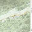
A 1:25000 scale map of the Antonine Wall was published by RCAHMS in 2008. The map shows the course of the Antonine Wall on a modern map base, including areas where the Wall is in public ownership or care and can be visited. The data had been collated as part of the project to prepare maps for the World Heritage Site nomination bid.

