
Pricing Change
New pricing for orders of material from this site will come into place shortly. Charges for supply of digital images, digitisation on demand, prints and licensing will be altered.
Garnhall


Temporary Camp (Roman)
Site Name Garnhall
Classification Temporary Camp (Roman)
Alternative Name(s) Castlecary Village, Antonine Wall, Garnhall 1
Canmore ID 45817
Site Number NS77NE 14
NGR NS 78593 78040
NGR Description Centre
Datum OSGB36 - NGR
Permalink http://canmore.org.uk/site/45817


- Council North Lanarkshire
- Parish Cumbernauld
- Former Region Strathclyde
- Former District Cumbernauld And Kilsyth
- Former County Dunbartonshire
NS77NE 14 78500 78030
(NS 78500 78030) Roman Camp (R) (site of)
OS 1:10000 map (1976)
A crop mark, which appears to be a Roman temporary camp, is visible on the west side of the deep little valley west of Castlecary fort. In field 337 (OS 25") south of the main Glasgow road, a line of ditch has been seen defining 750ft of the south east side and some 200ft of the north east of an enclosure. There is a break as for a gate in the south east side, and the postulated east angle lies at the margin of the found where it is invisible. There is space here for a camp at least 500 by 70 ft, beside the military way.
J K St Joseph 1955
No traces of this Roman camp were found in a cultivated field.
Visited by OS (JLD) 18 January 1957
Above confirmed.
Site surveyed at 1:2500 from air photographs.
Visited by OS (WDJ) 7 April 1967
A 400ft length of the north side and rounded north west angle of this camp have been established, giving axial dimensions of circa 850ft east-west by 570ft; much of the previously known perimeter on the south east and north east sides has been destroyed by roadworks.
J K St Joseph 1965
No change to previous reports.
Visited by OS (MJF) 20 April 1980
Excavation in advance of house-building revealed part of the S defences of this camp, known as Garnhill 1. The camp ditch was 2m wide and 60cm deep, but narrowed towards the W. There was no evidence of the corner-angle in the areas examined, to match that shown on current OS maps.
L Keppie and J Walker 1989.
Investigation was resumed in 1990 in advance of further housebuilding close to its SW corner. The ditch itself was 1.3m wide and 1m deep from the Roman ground surface. The SW corner of the camp was not located, but seemed likely to lie immediately W of the zone available for excavation.
L Keppie and J Walker 1990.
In advance of further housebuilding in Castlecary village, a search was made N of Castlecary Road for the NE corner angle of the camp. The E defensive ditch was located, width 1.15m, depth at least 0.6m; but the area had been much disturbed in the 19th century by the embankment of the adjacent Glasgow to Edinburgh railway-line, and more recently by the construction and subsequent demolition of Castlecary Village Hall.
There were no small finds.
Sponsor: Mr K McMillan, Castlecary House Hotel.
L Keppie 1992.
NS 7850 7803 An excavation was conducted within Garnhall 1 Roman temporary camp during July 1996 in advance of the construction of additional car parking space at Castlecary House Hotel. The area under investigation lay towards the W corner of the camp, and proved to have been greatly disturbed in recent times. Six trenches with a combined area of 170sqm, and 22 test-pits, were excavated. No features of archaeological significance were identified.
A report has been lodged with the NMRS.
Sponsor: Mr K MacMillan, Castlecary House Hotel.
K Cameron 1996
Aerial Photography (1951)
Aerial Photography (12 July 1952)
Field Visit (18 January 1957)
No traces of this Roman camp were found in a cultivated field.
Visited by OS (JLD) 18 January 1957
Aerial Photography (16 July 1958)
Aerial Photography (22 July 1962)
Aerial Photography (26 July 1962)
Aerial Photography (27 July 1963)
Field Visit (7 April 1967)
No traces of this Roman camp were found in a cultivated field.
Site surveyed at 1:2500 from air photographs.
Visited by OS (WDJ) 7 April 1967
Field Visit (20 April 1980)
No change to previous reports.
Visited by OS (MJF) 20 April 1980
Note (1982)
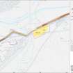
Garnhall 1, Temporary Camp NS 786 779 NS77NE 14
About 200m E of the site of Garnhall farm, and immediately S of the Antonine Wall, there is a camp, possibly one of the labour camps that housed a legionary detachment charged with the building of the Wall or the adjacent fort of Castlecary. Identified from crop-markings, the camp measures about 260m by 175m (4.5ha).
RCAHMS 1982
(St Joseph 1955, 86; 1965, 80)
Excavation (October 1989)
Excavation in advance of house-building revealed part of the S defences of this camp, known as Garnhill 1. The camp ditch was 2m wide and 60cm deep, but narrowed towards the W. There was no evidence of the corner-angle in the areas examined, to match that shown on current OS maps.
L Keppie and J Walker 1989.
Excavation (April 1990)
Investigation was resumed in 1990 in advance of further housebuilding close to its SW corner. The ditch itself was 1.3m wide and 1m deep from the Roman ground surface. The SW corner of the camp was not located, but seemed likely to lie immediately W of the zone available for excavation.
L Keppie and J Walker 1990.
Excavation (1992)
In advance of further housebuilding in Castlecary village, a search was made N of Castlecary Road for the NE corner angle of the camp. The E defensive ditch was located, width 1.15m, depth at least 0.6m; but the area had been much disturbed in the 19th century by the embankment of the adjacent Glasgow to Edinburgh railway-line, and more recently by the construction and subsequent demolition of Castlecary Village Hall.
There were no small finds.
Sponsor: Mr K McMillan, Castlecary House Hotel.
L Keppie 1992.
Excavation (October 1993)
NS 786 780 During October 1993, GUARD carried out archaeological excavations on part of this Roman temporary camp, in advance of private house building by Stewart Homes Ltd. Previous excavations had taken place on the site between 1989 and 1992.
The excavations investigated an 82m stretch of the southern perimeter ditch, incorporating an entrance area. The main aim of the excavations was to date the camp and to aid the interpretation of the site as either a marching or construction camp.
The excavation showed the camp to be of a single phase of construction. No evidence for the in situ survival of an internal rampart was found, although displaced turf blocks were present in the primary ditch fills. No evidence for a titulus at the entrance gap was found, although it may have lain outwith the investigated area.
No finds were recovered to aid the accurate dating of the site and no evidence was forthcoming to substantiate any accurate chronological relationship to either Castlecary Roman fort or the Antonine Wall. There was tentative evidence for the extended occupation of the site in the form of rampart repair, which would help support the theory that Garnhall was a construction camp. After abandonment of the camp, the ditches may have silted up through natural processes, although some evidence suggests a dumped backfill. There was evidence of re-use of the site after total silting of the ditches, in the form of an amorphous cobbled spread.
Sponsor: Stewart Homes Ltd.
K Speller 1994
Excavation (July 1996)
NS 7850 7803 An excavation was conducted within Garnhall 1 Roman temporary camp during July 1996 in advance of the construction of additional car parking space at Castlecary House Hotel. The area under investigation lay towards the W corner of the camp, and proved to have been greatly disturbed in recent times. Six trenches with a combined area of 170sqm, and 22 test-pits, were excavated. No features of archaeological significance were identified.
A report has been lodged with the NMRS.
Sponsor: Mr K MacMillan, Castlecary House Hotel.
K Cameron 1996
Publication Account (2008)
A 1:25000 scale map of the Antonine Wall was published by RCAHMS in 2008. The map shows the course of the Antonine Wall on a modern map base, including areas where the Wall is in public ownership or care and can be visited. The data had been collated as part of the project to prepare maps for the World Heritage Site nomination bid.
Publication Account (17 December 2011)
The remains of two camps at Garnhall were discovered from the air by St Joseph, the first in 1952, with a second, nearby, recognised as a camp in the early 1960s (St Joseph 1955: 86; 1965: 80). A third camp lies nearby at Tollpark (St Joseph 1951a: 62). The camps lie to the south of the Antonine Wall, between the forts of Castlecary and Westerwood, near the farm at Garnhall.
The ground on which both camps lie slopes gradually from west to east towards the Red Burn, across from which lies the fort of Castlecary. Both lie in areas of former agricultural fields now subject to considerable development, camp I on land formerly occupied by Castlecary House, now the village of Castlecary; camp II in improved pasture with the Wardpark North and East Industrial Estates in the immediate vicinity. Both camps have been subject to recent excavation, the former through the gradual development of Castlecary Village; the latter in relation to a research programme looking at potential watchtowers on the Wall, because a circular enclosure is located inside the camp’s perimeter (Woolliscroft 2009).
Camp I measures about 290m from ENE to WSW by around 160m transversely, enclosing an area of some 4.5ha (just over 11 acres), although the final size cannot be determined with certainty, partly owing to problems with transcription of the cropmarks (as a result of major landscape changes since the aerial photographs were taken and the need to use less accurately geo-referenced earlier maps), and partly owing to the findings from excavations. An entrance gap has been located on the SSE side, east of centre.
Sections of the camp have been excavated on five occasions, mostly owing to the gradual development of the village. That in 1990 suggested that the southwest corner was farther west than had previously been supposed (Keppie 1990). The results of the various excavations demonstrated that the camp ditch had a fairly typical V-shaped profile, measuring, at best, 1.3m in width and up to 1m in depth (Keppie 1990) and had a single construction phase. A small ditch appears to run due SSE at right angles from the west side of the entrance gap on the SSE side. This was excavated in 1994 and appeared to be contemporary with the camp ditch, the excavator suggesting that it acted as a gully to aid drainage down the slope to the Red Burn (Speller 1994).
The rampart of the camp was not recorded in the excavations, although turves were present in an anaerobic area of ditch in 1994. This area was interpreted as being close to a springhead, causing the waterlogging. The excavator proposed that the presence of turves could be due to possible rampart repairs necessary following subsidence caused by the springhead. This hypothesis was used to argue for possible extended occupation of the camp as a construction camp (Speller 1994: 17). While this argument has much to commend it, the possibility remains that the turves could be present owing to natural erosion, and were preserved in this section because of the boggy conditions.
Camp II is situated some 500m west of camp I. Only parts of two sides, the SSE and WSW, are known of this camp, lying in the two fields west of Garnhall Farm. The SSE side measures at least 300m, and the WSW some 133m before reaching the Antonine Wall. The elongated shape of this camp and the location of shorter WSW side, running up to the Wall and crossing the Military Way, led St Joseph to suggest that the camp probably continued to the north and therefore pre-dated the Wall (1965: 80). No entrances have been located.
In the interior of the camp lies a circular enclosure, excavated in the 1990s and interpreted as a watchtower (Woolliscroft 2009). In addition, a small excavation trench was opened up on the west side of the camp ditch and demonstrated that the ditch was V-shaped, measuring 1.73m in width and 1.27m in depth with the hint of a slot at the base. A trench at the potential intersection of the camp with the Antonine Wall located a rounded butt end terminal that was stratigraphically later than a stone platform protruding south from the Wall. This stone platform itself was later than the initial building phase of the Wall, and was slightly damaged by the construction of the camp, but not then repaired, suggesting that the platform had gone out of use by the time the camp was constructed (Woolliscroft 2009). However, because the function of the platform is uncertain, it is not possible to assess whether the Wall itself was abandoned by the time the camp was constructed, and the possible intersection with the Military Way was not explored. A further trench north of the Wall failed to locate any evidence for the continuation of the camp ditch.
Therefore, camp II post-dates a feature that is secondary to the Wall construction and does not fit in with the series of construction camps for the Antonine Wall. If the camp post-dates the occupation of the Wall, then it could have utilised the rampart of the Wall as its north side although it still represents an unusually elongated shape for a camp. If it represents an enclosure for a body of troops while the Wall was in operation then this begs the question of why a ditch was required, rather than just demarcate the area necessary, because presumably the immediate vicinity south of the Wall was a secure area.
R H Jones
Note (10 February 2022)
The location, classification and period of this site have been reviewed.

