
Following the launch of trove.scot in February 2025 we are now planning the retiral of some of our webservices. Canmore will be switched off on 24th June 2025. Information about the closure can be found on the HES website: Retiral of HES web services | Historic Environment Scotland
Dunmore


Cairn (Modern), Fort (Prehistoric) - (Early Medieval), Hut (Post Medieval), Hut Circle (Prehistoric)(Possible)
Site Name Dunmore
Classification Cairn (Modern), Fort (Prehistoric) - (Early Medieval), Hut (Post Medieval), Hut Circle (Prehistoric)(Possible)
Canmore ID 45294
Site Number NS68NW 10
NGR NS 60540 86474
Datum OSGB36 - NGR
Permalink http://canmore.org.uk/site/45294


- Council Stirling
- Parish Fintry
- Former Region Central
- Former District Stirling
- Former County Stirlingshire
NS68NW 10 6050 8647
A fort walled settlement (R W Feachem 1965) is situated upon the oval summit, measuring 530' x 170', of Dunmore.
The situation of the fort and the design and character of its defences suggest the probability that it is of Dark Age date. The name "Dunmore" may well apply to the fort rather than to the hill.
RCAHMS 1963, visited 1953
Dunmore fort is as described by the RCAHMS. The circular hut foundation and rectangular hut mentioned by the RCAHMS, and shown on their plan are firm constructions and are possibly shepherds' huts of a relatively recent date. The terrace wall S of the fort cannot be dated; while resembling a collapsed and robbed moorland stone dyke, it is obviously far earlier than the hut which is constructed upon it, and it is possibly contemporary with the major work.
Visited by OS (FDC) 10 April 1957
This fort is as described by the previous authorities.
Surveyed at 1:10,000.
Visited by OS (BS) 20 November 1975
Field Visit (19 May 1953)
NS68NW 605865 (unnoted)
Fort, Dunmore.
Dunmore, rising to a height of 1126 ft. above sea-level, is the northernmost hill-top of the Campsie Fells. It is situated half a mile W. of Fintry and dominates the narrow mouth of the Upper Endrick valley opposite the point where the Fintry Hills give way to the broad plain that stretches thence westwards to Loch Lomond. The rocky eminence forming the hilltop rises sharply from the high plateau to the S., across which the approaches are comparatively level, while to the N. the ground falls steeply to the river nearly 900 ft. below.
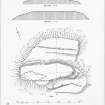
The summit of the hill consists in the main of an oval area measuring about 530 ft. from E. to W. by a maximum of 170 ft. transversely (Fig. 16). It is girt on all sides by steep, and in places precipitous, rocky slopes. Most of this area is comparatively level and covered in coarse pasture and heather, but the surface of the SW. quarter consists of bare rock. The remains of a stone wall (A in Fig. 16) are visible round much of the margin of the summit area. Judging by the amount and position of the debris, the wall seems to have been about 12 ft. in thickness at the base, and the lowest courses of the outer face appear to have been set into the rocky slopes of the hill, a few feet below the crest-line. No trace of wall debris can be seen along the SW. margin of the summit area, where the presumed line of the wall lies on a bare rocky cliff; but as soon as this gives way to the less severe W. and WNW. slopes a considerable amount of rubble remains to mark the course of the wall. After running NNE. for about 100 ft. the line of debris turns ESE. To follow the margin of the summit area for about 200 ft., when it is interrupted by a gully. This presumably formed the entrance to the fortified summit from an outer defensive area described below. The debris can be followed thereafter for about 60 ft., but beyond this point it is lost in coarse grass and heather until it reappears 200 ft. further on. From here it turns S. and SW. to round the E. extremity of the summit area, finally running W. for 200 ft. before meeting and dying out upon the rocky SW. crest-line.
The ESE. arc of the wall is covered by a horn-work (B) which runs along a subsidiary crest about 11 ft. below it for 150 ft. before dying out on the ever-steepening slopes of the rock at a distance of 30 ft. outside the main wall.
The rocky N. flank of the summit area falls only 36 ft. before reaching a broad ridge, the central spine of which increases in height as it runs ESE. To NW. the ridge is bounded by a steep, rocky slope which is a continuation of the NW. flank of the summit area. As this continues N. and NE. it becomes increasingly precipitous until, at the NE. corner of the ridge, it includes sheer rock-faces. A gully of ever-increasing breadth and depth starts at about the central point on the line of union between the summit and the ridge to the N. of it, running ESE. To merge eventually into the gentler rock-strewn slopes ESE. of both summit and ridge. Except to the ESE., therefore, the ridge is bordered by slopes and cliffs so precipitous as probably to render a defensive wall superfluous. From the NE. angle of the ridge, however, a wall 12 ft. in thickness (C) runs SSW. along the crest of the ESE. slope; on reaching the lip of the gully, which here, near the mouth, is 140 ft. in width and 20 ft. in depth, it descends into the gully, crosses the bottom, and ascends a little way up the opposite slope towards wall A. This feature recalls very precisely a wall which forms part of the fort on Rubers Law in Roxburghshire (1).
A gap about 4 ft. in width, which can be seen among the debris of wall C at the point where this crosses the bottom of the gully, presumably represents the entrance to this part of the fort, and from it the way is clear to the gap, mentioned above, which occurs in the N. sector of wall A.
A ruinous circular foundation (E) lies outside the fort on the slope 50 ft. ESE. of the entrance in the mouth of the gully. It consists of a ring of tumbled stones which measures 20 ft. in internal diameter and is presumably a hut-circle later in date than the fort.
A low rocky terrace, measuring about 400 ft. in length from E. to W. by about 120 ft. transversely, lies immediately S. of, and 38 ft. below, the E. half of the summit area and separates this from the moorland to the S. A ruinous stone wall (D) about 5 ft. 6 in. in thickness starts at the W. end of the terrace and runs E. along the middle of it, at first upon a line of outcropping rock, to die out among the rocks near the E. end. At a point 70 ft. from the W. end of this wall, a branch 20 ft. in length runs N. from it to the foot of the rocky slope here flanking the summit area. The little enclosure thus formed lies at the bottom of a narrow, natural crevice which runs NE. obliquely up the slope to the line of the main wall of the fort and which could have formed a subsidiary entrance to it. A gap about 6 ft. in width occurs about half-way along wall D on the terrace. This wall might be contemporary with the fort.
At a point a few yards W. of the entrance in wall D a small rectangular hut, measuring 14 ft. by 9 ft. within wall 2 ft. in thickness, has been built partly upon and partly within the ruin of the wall. This hut is comparable in size and appearance with the four that lie on the slopes of Dungoil (NS68SW 1), two and a half miles to the SE.
A modern cairn 6 ft. in height and 18 ft. in diameter, built from stones taken from the debris of the main wall, stands close to the SE. extremity of the summit area.
RCAHMS 1963, visited 19 May 1953.
(1) NT51NE 8; RCAHMS 1956, No. 145 (wall B, SE of the summit).
Reference (1957)
This site is noted in the ‘List of monuments discovered during the survey of marginal land (1951-5)’ (RCAHMS 1957, xiv-xviii).
Information from RCAHMS (GFG), 24 October 2012.
Note (1979)
Dunmore, Fintry NS 605 864 NS68NW 10
The remains of a massive wall 3.5m thick, which has been built round the summit of Dunmore to enclose an area measuring about 150m by 45m, forms the 'citadel' of a Dark Age fort. Below the summit to the NE there is a large annexe bounded on the E by an outer wall and elsewhere by precipitous natural slopes; a rocky terrace S of the summit also carries remains of walling, which may likewise be contemporary with the fort.
RCAHMS 1979
(RCAHMS 1963, pp. 76-8, no. 77)
Note (12 August 2014 - 16 November 2016)
This fort occupies the rock-girt summit of Dunmore, the hill overlooking Fintry from the WSW. Oblong on plan, it measures about 158m from ESE to WNW by 45m transversely (0.55ha) within a ruined wall about 3.5m in thickness, though this disappears along the SW margin of the summit and elsewhere is largely reduced to a band of rubble with a few outer facing-stones visible a little below the crest of the rocky slope. An outer rampart can be seen on the SE, detaching itself from the main wall and following a natural crest about 3m lower down the slope, and there is a further outwork crossing the gully at the foot of the summit ridge on the E and extending along the E face of a lower terrace, combining with the topography of the outcrops elsewhere to form an annexe measuring about 130m from ESE to WNW by 65m transversely (0.8ha). The main entrance to the fort is on the N, where a gully drops down into the annexe, and there is also a narrow gap in the annexe wall in the bottom of the gully on the ESE. What may be a second entrance on the S descends via a narrow crevice to a lower terrace flanking this side of the fort, extending along which there are traces of a narrow wall of unknown date or purpose; at one point this wall is overlain by the stone footing of a rectangular building.
Information from An Atlas of Hillforts of Great Britain and Ireland – 16 November 2016. Atlas of Hillforts SC1477

