
Pricing Change
New pricing for orders of material from this site will come into place shortly. Charges for supply of digital images, digitisation on demand, prints and licensing will be altered.
Upcoming Maintenance
Please be advised that this website will undergo scheduled maintenance on the following dates:
Thursday, 9 January: 11:00 AM - 3:00 PM
Thursday, 23 January: 11:00 AM - 3:00 PM
Thursday, 30 January: 11:00 AM - 3:00 PM
During these times, some functionality such as image purchasing may be temporarily unavailable. We apologise for any inconvenience this may cause.
Glasgow Bridge


Fortlet (Roman)
Site Name Glasgow Bridge
Classification Fortlet (Roman)
Alternative Name(s) Antonine Wall; Easter Cadder
Canmore ID 45253
Site Number NS67SW 21
NGR NS 63662 73097
Datum OSGB36 - NGR
Permalink http://canmore.org.uk/site/45253


- Council East Dunbartonshire
- Parish Cadder (Strathkelvin-du)
- Former Region Strathclyde
- Former District Strathkelvin
- Former County Lanarkshire
NS67SW 21 63660 73097
See also NS67SW 45.00 (Antonine Wall).
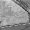
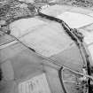
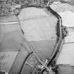
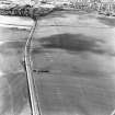
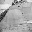
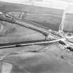
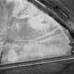
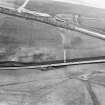
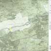
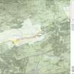
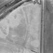
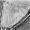
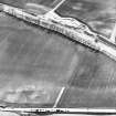
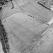
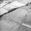
(NS 63662 73097) Roman Fortlet, Glasgow Bridge (Site: Crop-markings on CUCAP and RCAHMS air photographs (QW 90-4: flown 14 July 1955; LA 2226-8, flown 1977) reveal the presence of a fortlet attached to the S side of the Antonine Wall 180m ENE of Glasgow Bridge. It occupies a moderately strong position on the brow of a north-facing slope. Probably measuring some 20m square internally, it has been defended on the NW by the Antonine Wall and on the other three sides by a rampart and single ditch. A gap in the ditch shows that there was an entrance in the centre of the SE side, and it can be assumed that there was another entrance in a corresponding position on the NW side; in the latter case, however, the Antonine Ditch must have been bridged, as no traces of a causeway are visible on the air photographs. This fortlet is comparable with that at Wilderness Plantation, and was presumably intended for a similar purpose: cf NS57SE 11. (Fortlet published on OS Antonine Wall Map 1969).
RCAHMS 1978, visited 1973.
There are no visible surface remains of this fortlet, the site of which lies in a pasture field. Its ditch and rounded NE angle are visible on the RAF air photograph (F21/82/RAF/1236: 0171).
Visited by OS (D S), 18 January 1957.
Under crop; no surface traces remain.
Visited by OS (D S), 18 January 1957.
Scheduled with length of Antonine Wall from NS c. 63562 73004 to NS c. 64223 73575 (NS67SW 45.00), Roman temporary camp (NS67SW 24), and henge (NS67SW 27).
[Location map supplied].
Information from Historic Scotland, scheduling document dated 25 June 2010.
Aerial Photography (11 July 1955)
Its ditch and rounded NE angle are visible on the RAF air photograph (F21/82/RAF/1236: 0171).
Field Visit (18 January 1957)
There are no visible surface remains of this fortlet, the site of which lies in a pasture field.
Under crop; no surface traces remain.
Visited by OS (D S) 18 January 1957.
Field Visit (1973)
Visited 1973.
Note (1982)
Glasgow Bridge, Fortlet NS 636 731 NS67SW 21
This fortlet, which was first identified from crop marks, abuts the S side of the Antonine Wall about 390m ESE of Easter Cadder farmhouse. It appears to measure about 20m square internally.
RCAHMS 1982
(RCAHMS 1978, p. 134, No. 257; Keppie and Walker 1981)
Project (4 February 2008 - 15 February 2008)
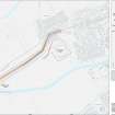
The Antonine Ditch has been clearly detected by both survey techniques; the magnetic response is generally uniform across the site while the resistance anomalies vary, depending on localised natural factors. Evidence for the Rampart is more tentative and intermittent, though at their most coherent, the magnetic responses suggest a partially intact base constructed of highly magnetic cobbles. The Military Way remains elusive; though a few faint trends have been identified which might represent the line of the road, natural and modern agricultural factors make this interpretation highly inconclusive. The ditches of the fortlet appear in both datasets but no obvious internal features have been detected. No anomalies that can be obviously attributed to postulated Rampart towers have been identified; the nature of these features makes them very difficult to detect by either technique, thus an absence of geophysical evidence cannot prove or disprove their presence along the Antonine Wall.
OASIS ID: gsbprosp1-43972
Magnetometry (4 February 2008 - 15 February 2008)
Magnetometry survey.
OASIS ID: gsbprosp1-43972.
Resistivity (4 February 2008 - 15 February 2008)
Resistivity survey.
OASIS ID: gsbprosp1-43972.
Resistivity (4 February 2008 - 15 February 2008)
Resistivity survey.
OASIS ID: gsbprosp1-43972
Magnetometry (4 February 2008 - 15 February 2008)
Magnetometry survey.
OASIS ID: gsbprosp1-43972
Project (4 February 2008 - 15 February 2008)
A series of geophysical survey techniques were employed to identify and accurately locate the Antonine Wall, any traces of the Military Way and the fortlet at Glasgow Bridge and to identify any other features which might be associated with the fortlet or the Wall. In particular it was hoped that a large scale magnetic survey across an uninterrupted stretch might prove useful in assessing whether towers/turrets were present along the line of the Rampart. The workforms part of a continuing programme of research commissioned by Historic Scotland, as part of their proposal to promote the Antonine Wall to World Heritage Status.
The Antonine Ditch has been clearly detected by both survey techniques; the magnetic response is generally uniform across the site while the resistance anomalies vary, depending on localised natural factors. Evidence for the Rampart is more tentative and intermittent, though at their most coherent, the magnetic responses suggest a partially intact base constructed of highly magnetic cobbles. The Military Way remains elusive; though a few faint trends have been identified which might represent the line of the road, natural and modern agricultural factors make this interpretation highly inconclusive. The ditches of the fortlet appear in both datasets but no obvious internal features have been detected. No anomalies that can be obviously attributed to postulated Rampart towers have been identified; the nature of these features makes them very difficult to detect by either technique, thus an absence of geophysical evidence cannot prove or disprove their presence along the Antonine Wall.
OASIS ID: gsbprosp1-43972.
Magnetometry (4 February 2008 - 15 February 2008)
Magnetometry (10 November 2008 - 14 November 2008)
The study area was surveyed twice with the gradiometer: in the first data set (Area 1) the traverses run perpendicular to the Wall, in the second (Area 2) they are aligned parallel with it. The results show only a marginal change in definition of the Ditch, but a slightly greater impact on the
Rampart, with Area 1 producing the more coherent responses. Anomalies perpendicular to the wall were better defined in Area 2. By processing the Area 2 data it has been possible to remove the visually prevalent Ditch and Rampart anomalies and isolate a few smaller scale non-linear responses. However, assessing the archaeological significance of these responses remains problematic due to the naturally high magnetic background and the usefulness of this approach in identifying postulated towers is unproven.
Responses from modern cultivation visually dominate the resistance data. Sections of Rampart appear as relatively well defined high resistance anomalies while the Ditch has produced only intermittent and somewhat ill defined high resistance bands. It appears that the high ground and relatively good drainage has enhanced the ploughing trend while reducing the moisture contrast between the Ditch fill and the surrounding soil. Overall, however, the resistance survey has added little to the assessment of the site.
C. Stephens
Resistivity (10 November 2008 - 14 November 2008)
The study area was surveyed twice with the gradiometer: in the first data set (Area 1) the traverses run perpendicular to the Wall, in the second (Area 2) they are aligned parallel with it. The results show only a marginal change in definition of the Ditch, but a slightly greater impact on the
Rampart, with Area 1 producing the more coherent responses. Anomalies perpendicular to the wall were better defined in Area 2. By processing the Area 2 data it has been possible to remove the visually prevalent Ditch and Rampart anomalies and isolate a few smaller scale non-linear responses. However, assessing the archaeological significance of these responses remains problematic due to the naturally high magnetic background and the usefulness of this approach in identifying postulated towers is unproven.
Responses from modern cultivation visually dominate the resistance data. Sections of Rampart appear as relatively well defined high resistance anomalies while the Ditch has produced only intermittent and somewhat ill defined high resistance bands. It appears that the high ground and relatively good drainage has enhanced the ploughing trend while reducing the moisture contrast between the Ditch fill and the surrounding soil. Overall, however, the resistance survey has added little to the assessment of the site.
C. Stephens
Publication Account (2008)
A 1:25000 scale map of the Antonine Wall was published by RCAHMS in 2008. The map shows the course of the Antonine Wall on a modern map base, including areas where the Wall is in public ownership or care and can be visited. The data had been collated as part of the project to prepare maps for the World Heritage Site nomination bid.

