
Summerston


Fortlet (Roman), Temporary Camp (Roman)
Site Name Summerston
Classification Fortlet (Roman), Temporary Camp (Roman)
Alternative Name(s) Antonine Wall
Canmore ID 44482
Site Number NS57SE 18
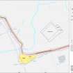
NGR NS 5742 7245
Datum OSGB36 - NGR
Permalink http://canmore.org.uk/site/44482


- Council Glasgow, City Of
- Parish New Kilpatrick (City Of Glasgow)
- Former Region Strathclyde
- Former District City Of Glasgow
- Former County Dunbartonshire
NS57SE 18 574 723
See also NS57SE 20.
The position of a temporary construction-camp first identified from the air was confirmed by excavation in 1980. It measured c. 170 by 140m (c. 2.4 ha) and showed only one phase of occupation. To the north lay a second enclosure measuring 35m E-W by 33m; this should probably be recognised as the ninth fortlet to be found on the Antonine Wall. The E ditch was 1.6m wide and 0.75m deep, but no trace of a rampart survived; a possible pot-hole was the only internal feature.
R Goodburn 1978; F O Grew 1981; G S Maxwell and W S Hanson 1981; G S Maxwell and W S Hanson 1983.
No trace in gently undulating arable fields.
Visited by OS 29 April 1981.
Fortlet measured about 30m square within a single ditch, and post-dated the temporary camp.
G S Maxwell and D R Wilson 1987.
Aerial Photography (1977)
Site discovered through aerial photography.
Aerial Photography (1979)
Excavation (November 1980)
The position of a temporary construction-camp first identified from the air was confirmed by excavation in 1980. It measured c. 170 by 140m (c. 2.4 ha) and showed only one phase of occupation. To the north lay a second enclosure measuring 35m E-W by 33m; this should probably be recognised as the ninth fortlet to be found on the Antonine Wall. The E ditch was 1.6m wide and 0.75m deep, but no trace of a rampart survived; a possible pot-hole was the only internal feature.
R Goodburn 1978; F O Grew 1981; G S Maxwell and W S Hanson 1981; G S Maxwell and W S Hanson 1983.
Field Visit (29 April 1981)
No trace in gently undulating arable fields.
Visited by OS 29 April 1981.
Publication Account (1987)
Fortlet measured about 30m square within a single ditch, and post-dated the temporary camp.
G S Maxwell and D R Wilson 1987.
Publication Account (2008)
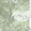
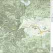
A 1:25000 scale map of the Antonine Wall was published by RCAHMS in 2008. The map shows the course of the Antonine Wall on a modern map base, including areas where the Wall is in public ownership or care and can be visited. The data had been collated as part of the project to prepare maps for the World Heritage Site nomination bid.
Publication Account (17 December 2011)
The camp at Summerston lies immediately south of the Antonine Wall, next to a nearby fortlet, the ditch of which was aligned to deliberately avoid the camp. It was first discovered from the air by Maxwell in 1977 (Goodburn 1978: 413). Parts of three sides of the camp have been visible as cropmarks, and the camp measures about 162m from north to south by at least 75m transversely and probably 140m, enclosing an area of some 2.3ha (5.9 acres). It has not been possible to detect any entrances in the sides – there are breaks in the east and south sides, but these may be due to partial cropmarks rather than obvious entrance gaps. Excavation in 1980has dated the camp to the Antonine period, as it is of a single construction phase and slightly pre-dated the adjacent fortlet (Hanson and Maxwell 1986: 118–19). They also recorded that the ditch was up to 1.6m in width and 0.75m in depth (Maxwell and Hanson n.d.).
Illustration 202 includes information on the north side from Maxwell and Hanson’s excavations (Maxwell and Hanson n.d.).
R H Jones.

