
Pricing Change
New pricing for orders of material from this site will come into place shortly. Charges for supply of digital images, digitisation on demand, prints and licensing will be altered.
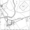
Balmuildy, Roman Bridge


Bridge (Roman)
Site Name Balmuildy, Roman Bridge
Classification Bridge (Roman)
Alternative Name(s) River Kelvin; Balmuildy Bridge
Canmore ID 44478
Site Number NS57SE 14
NGR NS 5803 7185
Datum OSGB36 - NGR
Permalink http://canmore.org.uk/site/44478


- Council Glasgow, City Of
- Parish Cadder (City Of Glasgow)
- Former Region Strathclyde
- Former District City Of Glasgow
- Former County Lanarkshire
NS57SE 14 5803 7185
Not to be confused with NS57SE 129.
(NS 5803 7185) Roman Bridge (R) (site of)
OS 6" map, (1971)
One oak beam and five Roman stones from the piers of the bridge are in the Hunterian Museum, Glasgow.
Information from A S Robertson to OS, 1951.
In 1941, when the River Kelvin was being deepened at Summerston by the Dept of Agriculture, debris of a bridge which had carried the Military Way was dredged up from the river. The circumstances of the discovery make it impossible to be certain about its precise position or plan, but evidently some of the stone blocks recovered had belonged to an abutment on the river bank, while others, bearing obtuse-angled faces may have formed part of the cut-water of a free-standing pier. The absence of voussoirs suggests that the platform of the bridge was of timber, and in fact some of the shaped beams found during dredging operations may have come from the superstructure; the round-sectioned piles, on the other hand, probably served as the foundations of a stone pier.
S N Miller 1952; RCAHMS 1978.
No trace of the bridge could be found.
Visited by OS (R D) 19 January 1966.
A timber beam recovered from the Kelvin in 1942 which was thought to be part of the Antonine Wall bridge was found on examination to be from a tree felled about 1360 AD.
L Keppie and M Baillie 1979.
No further information.
Visited by OS (M J F) 30 June 1980.
In May 1982 dredging of the Kelvin N of Balmuildy fort pulled up a number of worked stone blocks, some with dove-tail cramp-holes, clearly deriving from the stone piers of the bridge, originally discovered during similar operations in 1942. It is hoped to transfer some of the blocks of the Hunterian Museum for display.
L J F Keppie and J J Walker 1982.
The River Kelvin here forms the boundary between the parishes of Cadder (to the S) and New Kilpatrick (to the N).
Information from RCAHMS (RJCM), 23 December 2005.
Salvage Record (1941)
In 1941, when the River Kelvin was being deepened at Summerston by the Dept of Agriculture, debris of a bridge which had carried the Military Way was dredged up from the river. The circumstances of the discovery make it impossible to be certain about its precise position or plan, but evidently some of the stone blocks recovered had belonged to an abutment on the river bank, while others, bearing obtuse-angled faces may have formed part of the cut-water of a free-standing pier. The absence of voussoirs suggests that the platform of the bridge was of timber, and in fact some of the shaped beams found during dredging operations may have come from the superstructure; the round-sectioned piles, on the other hand, probably served as the foundations of a stone pier.
S N Miller 1952; RCAHMS 1978.
Note (1951)
One oak beam and five Roman stones from the piers of the bridge are in the Hunterian Museum, Glasgow.
Information from A S Robertson to OS, 1951.
Field Visit (19 January 1966)
No trace of the bridge could be found.
Visited by OS (R D) 19 January 1966.
Publication Account (1979)
A timber beam recovered from the Kelvin in 1942 which was thought to be part of the Antonine Wall bridge was found on examination to be from a tree felled about 1360 AD.
L Keppie and M Baillie 1979.
Field Visit (30 June 1980)
No further information.
Visited by OS (M J F) 30 June 1980.
Salvage Record (May 1982)
In May 1982 dredging of the Kelvin N of Balmuildy fort pulled up a number of worked stone blocks, some with dove-tail cramp-holes, clearly deriving from the stone piers of the bridge, originally discovered during similar operations in 1942. It is hoped to transfer some of the blocks of the Hunterian Museum for display.
L J F Keppie and J J Walker 1982.
Publication Account (1982)
The exact position of the bridge that may be presumed to have carried the Military Way across the River Kelvin is not known. However, it is conceivable that the medieval bridge (Keppie and Baillie 1979) stood on approximately the same site as a Roman predecessor.
RCAHMS 1982.
Note (1982)
Balmuildy Bridge NS c. 58 71 NS57SE 14
The exact position of the bridge that may be presumed to have carried the Military Way across the River Kelvin is not known. Timbers and blocks of masonry that were dredged from the river bed in 1942, about 90m NNW of Balmuildy fort (NS57SE 12), were originally thought to be of Roman origin, but dendrochronological analysis of one of the timbers showed that it was felled no earlier than AD 1360; the date of the dressed stones must thus be called in question, but it is conceivable that the medieval bridge stood on approximately the same site as a Roman predecessor.
RCAHMS 1982
(RCAHMS 1978, pp. 114-19, No. 248; DES, 1979, 40)
Note (23 December 2005)
The River Kelvin here forms the boundary between the parishes of Cadder (to the S) and New Kilpatrick (to the N).
Information from RCAHMS (RJCM), 23 December 2005.

