
Pricing Change
New pricing for orders of material from this site will come into place shortly. Charges for supply of digital images, digitisation on demand, prints and licensing will be altered.
Luss, St Kessog's Church And Churchyard


Burial Ground (Medieval) - (Post Medieval), Chapel (Early Medieval), Church (Medieval) - (Post Medieval), Grave Slab(S) (Medieval), War Memorial (20th Century)
Site Name Luss, St Kessog's Church And Churchyard
Classification Burial Ground (Medieval) - (Post Medieval), Chapel (Early Medieval), Church (Medieval) - (Post Medieval), Grave Slab(S) (Medieval), War Memorial (20th Century)
Alternative Name(s) Luss Village, St Mackessog's Church Of Scotland And Burial-ground; Loch Lomond; Luss Parish Church And Hog-backed Stone; War Memorial Plaque
Canmore ID 42529
Site Number NS39SE 1
NGR NS 36100 92865
Datum OSGB36 - NGR
Permalink http://canmore.org.uk/site/42529


- Council Argyll And Bute
- Parish Luss
- Former Region Strathclyde
- Former District Dumbarton
- Former County Dunbartonshire
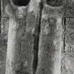
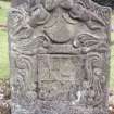
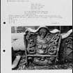
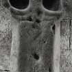
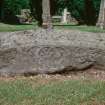
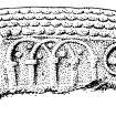
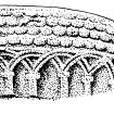
Luss 1 (St Kessog), Dunbartonshire, hogback gravestone
Measurements: L 1.78m, W 0.33m at the W end to 0.40m in the centre, H 0.18m at the W end to 0.43m at the centre.
Stone type: sandstone
Place of discovery: NS 3610 9286
Present location: in Luss churchyard to the east of the present church, lying E-W.
Evidence for discovery: first recorded in the mid nineteenth century in its current location. This ancient church-site lies close to the point at which the Luss Water flows into Loch Lomond.
Present condition: very weathered.
Description
This was originally a simple tegulated monument with a pronounced curve to its ridge and four rows of semi-circular tegulae along both sides. It seems to have been modified (and perhaps re-used) by removing the lower rows of tegulae and making the lower part of the stone vertical. The north side was then carved with Romanesque arcading and the south side with arcading and three circular designs, two of which are cruciform.
Date range: eleventh to early twelfth century.
Primary references: Russell Walker 1885, 418-19; Lang 1974, 218-18, 220; Fisher 2001, 84-5, no 14 (3); Ritchie 2004, 4, 17.
Desk-based information compiled by A Ritchie 2019
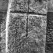
Luss 2 (St Kessog), Dunbartonshire, cross-slab
Measurements: H 1.63m, W 0.36m, D 0.18m
Stone type: slate
Place of discovery: NS 3610 9286
Present location: in Luss churchyard.
Evidence for discovery: recorded in the early 1920s by Lacaille. This ancient church-site lies close to the point at which the Luss Water flows into Loch Lomond.
Present condition: the top right corner is damaged but the carving is good.
Description
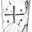
Spanning the width of one broad face of this rectangular slab is an incised equal-armed cross.
Date range: early medieval.
Primary references: Lacaille 1925, 144; Fisher 2001, 84-5, no 14 (1).
Desk-based information compiled by A Ritchie 2019
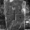
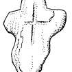
Luss 3 (St Kessog), Dunbartonshire, cross-slab
Measurements: H 0.75m, W 0.47m, D 0.09m
Stone type: sandstone
Place of discovery: NS 3610 9286
Present location: in Luss churchyard.
Evidence for discovery: recorded in the early 1920s by Lacaille. This ancient church-site lies close to the point at which the Luss Water flows into Loch Lomond.
Present condition: the right-hand side is damaged but the carving is good.
Description
This slab is incised with an equal-armed cross with small pits at the outer edge of the spaces between the arms.
Date range: early medieval.
Primary references: Lacaille 1925, 144; Fisher 2001, 84-5, no 14 (2).
Desk-based information compiled by A Ritchie 2019
Field Visit (18 January 1963)
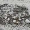
To the east of Luss church are two fragments of rubble masonry, each about 3.0 metres long by 1.5 metres high and 0.8. metres thick. Each fragment incorporates a grave slab, and one dated 1778, the other 1789, thus the walling may not be older than these dates. The sepulchral monuments are still in the churchyard.
Visited by OS (WDJ) 18 January 1963
Field Visit (August 1977)
Parish Church, Luss NS 361 928 NS39SE 1
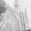
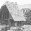
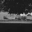
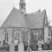
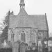
The first reference to a church at Luss is in the mid-14th century, but in the churchyard are two cross-slabs, probably of 7th- to 9th-century date, and a hogback of 11th-century date, which suggest that there was a church on the site considerably before this. There are the very slight remains of an earlier building immediately to the E of the existing church, which was not built until 1875.
RCAHMS 1978, visited August 1977
(OPS 1851-5, i, 30; Lacaille 1925, 144-6; Lang 1974, 217-8, 229)
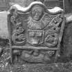
Reference (2001)
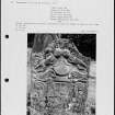
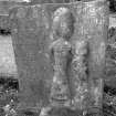
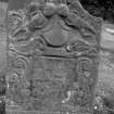
The medieval parish church of Luss, like its successor of 1771 and the present building of 1875, stood on the N bank of the Luss Water and 130m from the W shore of Loch Lomond. The church was dedicated to St Kessog, who is associated with the neighbouring island of Inchtavannach, and his bell was supposedly preserved on the island until the 19th century (a). The medieval effigy of an abbot or bishop, now much re-tooled, was found in the late 18th century in a cairn at Bandry (NS 3584 9003), the reputed site of Kessog's martyrdom, and is displayed in the church (b). Two cross-marked stones and a hogback grave-cover are in the churchyard, as well as a late medieval cross and at least five coped grave-covers (c).
(1) Rectangular slab of slate, broken at the top and foot and measuring 1.16m in height by 0.36m and 0.18m in thickness. One face has been roughly dressed with a pick and bears a cross incised with a U-section groove, 0.39m high and 0.34m across the side-arms. These are set a little above mid-height and extend to the edges of the slab, while the shaft, which is slightly curved, has rounded terminals.
(A D Lacaille 1925, 144 and fig.1 on p.145).
(2) Slab of red sandstone, 0.75m in height by 0.47m and 85mm in thickness. It is broken at the top right and much worn and flaked, but a cross is firmly incised on one face with a broad U-section groove. It measures 0.29m in height by 0.33m across the side-arms, which are set at mid-height. The terminals are slightly expanded and rounded, and in the four cantons there are hollows about 30mm in diameter.
(A D Lacaille 1925, 144 and fig.2 on p.145).
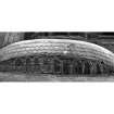
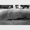
(3) Hogback grave-cover of grey sandstone with curved sides and ridge, lichen-stained and cracked and flaked in places. It is 1.78m long and at the centre is 0.43m high by 0.4m wide, tapering at the W end to 0.18m by 0.33m and at the E to 0.25m by 0.38m. The ridge appears to have been a plain raised band about 60mm wide but is now almost obliterated. On each slope of the roof, and following the curve of the ridge, there are four rows of round-ended tegulations. The sides of the stone are vertical and have been re-cut in Romanesque style, the N side bearing in false relief an arcade of nine bays. This has intersecting double-beaded round arches springing from plain pillars with block capitals but no bases. The S side bears at the centre a four-bay arcade with simple arch-heads enclosing pellets, and to the right there are three roundels, enclosing respectively a quatrefoil in false relief, a cross with curved arms and central pellet, and a triskele with concave sides. The ends taper slightly downwards from eaves-level (d).
Lang assigned this monument, on the basis of the curvature of the ridge and cross-section, to the earliest group of Scottish plain tegulated hogbacks, and proposed an 11th-century date. The arcades and roundels on the sides are clearly alterations of the following century, and the entire surfaces of both sides were re-dressed at that period. The continuing popularity of tegulated ornament at Luss in the 12th and 13th centuries is seen in several of the coped monuments recorded in the churchyard.
Footnotes:
(a) OPS 1851, 30-1; Sir W Fraser 1869, 2, 46-57, 138-42, 272-3; W J Watson 1926, 277-8; A D Lacaille 1928, 85-8; A D Lacaille 1934, 115-16. The possession of 'the bell and alms of St Cassog' was confirmed to George Buchanan of Buchanan in 1567 (Reg Magni Sig Reg Scot, 4 (1546-80), no.1757). Robert I in 1315/16 confirmed 'to God and St Kessog' the right of sanctuary for 4.9km in all directions (W Fraser 1869, 2, 58-9, 276).
(b) Stat. Acct., 17, 264; NSA, 8 (Dumbarton), 161; W Fraser 1869, 2, 54-6; R Brydall 1908, 23-4; A D Lacaille 1934, 100-11.
(c) R Brydall 1908, 23-6; A D Lacaille 1925, 145-6; A D Lacaille 1927, 140-1; A D Lacaille 1928, 88-96. For the possible removal of other medieval stones, see A Ritchie 1994, 45.
(d) J R Walker (1885, 418) thought that one end resembled the head of a fish. This may refer to a horizontal groove and a hollow at the W end of the N side, both of which appear to be natural.
T S Muir 1861, 26; J R Walker 1885, 418 and fig.9 on p.419 (reproduced in Allen 1902, fig. opp. p.402; A D Lacaille 1928, fig.2 on p.91); R Brydall 1908, 25 and fig.2; J T Lang 1975, 217-18, 220 and pl.16a, b.
I Fisher 2001, 84-5.
Watching Brief (2002)
NS 3610 9285 A watching brief was kept during the excavation of new drains and paths, solum of the church and replacement grave foundations. A medieval West Highland coped stone of fine-grained sandstone was noted, measuring 1.72m long and 0.21m high (max.) and a maximum of 0.42m wide, and tapering towards the foot end. It is broken in two pieces about two-thirds of the way down its length. Of the three coping panels, the two side panels have foliate design and the top panel bears only a single initial 'C' at the head end in crisp Latin script. No other carvings are present. It was discovered in the foundations of a late 19th-century grave during repair works, and the medieval stone is not in its original position. It has been raised to the ground surface in the same position in the cemetery to be on public display.
Immediately adjacent to the coped stone was a slate slab in situ. The 1.8m slab is plain and unfinished from the nearby Camstraddan quarry, with the exception of a small 8cm cross scratched on it towards the southern side of the foot end. The cross has been embellished around its branches, perhaps to create a Celtic cross, but it is difficult to decipher precisely. The slab has been left in situ and it appears undisturbed, confirming that the top 0.2m of the cemetery soil was substantially disturbed during the late 19th century when the standing church was built and the graveyard was 'tidied'.
During the excavations of the 19th-century grave foundations a fragment of slate that appears to bear a fragment of a cross was recovered. It is possible this slate is a fragment of a simple medieval grave marker. A small assemblage of medieval and post-medieval pottery was recovered from the graveyard soil, including Scottish medieval redwares, Scottish White Gritty and post-medieval reduced ware. The majority of the sherds were found in the area immediately N of the W porch. Three overgrown gravestones last recorded in 1926 were rediscovered, and it was confirmed that the 12th-century coped stone described and illustrated by Lacaille (PSAS 1927-28, 93-5) was destroyed beyond repair in the 1970s.
Excavations of the drains and in the interior of the church revealed glimpses of the 17th-century church foundations, and the layout of the foundations of the c 13th-century chapel to the E of the standing building was confirmed. In the lane leading down to Loch Lomond on the NE side of the churchyard a substantial infill deposit of 18th- to 19th-century midden on rubble was encountered to a depth of 2m but was not bottomed. It may simply represent building up of the lane which is only 30m from the loch, but may represent infill of an earlier ditch or vallum.
Several architectural fragments were recovered from the interior of the church, the graveyard and associated with the 13th-century chapel; these are stored on site. Two broken 18th-century gravestone fragments were recovered from 19th-century gravestone foundations, one of which is a fine trade stone of a shipwright; this is now on display in the cemetery.
The early cross slabs, the font, the 14th-century effigy and the Celtic head have been cleaned and conserved and remain on site.
Report to be deposited in WoSAS SMR and the NMRS.
Sponsors: HS, HLF, Congregational Board of Luss Church, Church of Scotland.
F Baker 2002
Photogrammetric Survey (21 October 2014 - 23 October 2014)
NN 32882 05398 The ACCORD (Archaeology Community Co-production Of Research Data) Project was an Arts and Humanities Research Council (AHRC) funded research project led by the Digital Design Studio (Glasgow School of Art), with the University of Manchester, RCAHMS and Archaeology Scotland, which worked with 10 community groups across Scotland from October 2013 to March 2015. The project aimed to co-design and co-produce 3D digital data of heritage sites that are of significance to the community groups and which they wished to record.
The ACCORD team worked with a group that was excavating medieval remains on Tarbet Isle on a community excavation run by Northlight Heritage with professional archaeologist Heather James, from the 21–23 October 2014. This group included two American-Scots who claim roots to the Clan MacFarlane and volunteer amateur archaeologists. Employing the technique of photogrammetry, we 3D recorded and modelled the excavated trenches on the island, which have uncovered the foundations of a building dating to the medieval period and a 1612 plaque built into the church wall at Luss (NS 36100 92865), dedicated to clan chieftain, John MacFarlane.
Archive: ADS and National Record of the Historic Environment (NRHE)
Funder: Arts and Humanities Research Council
Stuart Jeffrey and Mhairi Maxwell – Glasgow School of Art
(Source: DES, Volume 16)
Desk Based Assessment
NS39SE 1 36100 92865
For (associated) Luss parish manse (NS 3607 9291), see NS39SE 42.
(NS 3612 9286) Church (NR) (Ruins).
OS 6" map (1923)
(NS 3613 9286) Stone coffins found here (NAT)
OS 6" map (1860)
The church of Luss is first mentioned in the middle of the 13th century. The first post-Reformation church was built on the same site and the church of 1771 now stands a few feet from the remains of 'the old church'.
W Fraser 1869
The church is dedicated to St Kessog.
R Chalmers 1890
The present church of Luss was built in 1875 and succeeds a church opened for worship in 1771 which was erected on the site of a pre-Reformation chapel. A few yards from the east end of the church are the remains of a wall of rough stone masonry of of unknown date.
In the churchyard is a hog-backed stone and sepulchral monuments, some sculptured and of mediaeval and early post-Reformation date.
St Kessog is said to have been buried at Luss in the early part of the sixth century.
A D Lacaille 1925
Luss (Glasgow, Lennox). Both parsonage and vicarage were erected into a prebend of Glasgow cathedral by Bishop John Cameron c. 1430, the patronage remaining with the Colquhouns of Luss, as it did at the Reformation, while the cure was served by a vicar pensioner.
I B Cowan 1967.
Information from OS.

