
Bute, Craigandun


Enclosure (Period Unassigned)
Site Name Bute, Craigandun
Classification Enclosure (Period Unassigned)
Alternative Name(s) Craigandun, Dun Hill, Cnoc-an-dun, Dunalunt
Canmore ID 40385
Site Number NS06SE 20
NGR NS 05039 63976
Datum OSGB36 - NGR
Permalink http://canmore.org.uk/site/40385


- Council Argyll And Bute
- Parish North Bute
- Former Region Strathclyde
- Former District Argyll And Bute
- Former County Buteshire
NS06SE 20 05039 63976.
(NS 0504 6397) Earthwork (R)
OS 6" map (1957)
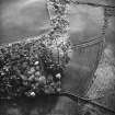
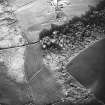
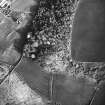
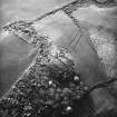
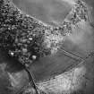
The top of Cnoc-an-Dun is enclosed within a flattened earthen rampart, 120ft in diameter, with an external ditch visible on the N and E sides. Four hollows, which Hewison suggested were hut circles, were found to be slight irregular depressions in the hill slope on the NW. The best one, 14ft in diameter, was excavated in 1955, but no trace of occupation or of hut walls was found. Soil may have been removed from the area when making the rampart, so leaving the depression.
J K Hewison 1893; D N Marshall 1963
Situated on the summit of a small steep-sided knoll are the remains of an enclosure. The single earthen bank, up to 2.0m wide, 1.0m high externally and 0.2m internally survives on the W, S and E sides only and encloses an area of 42.0m E-W by approx 32.0m transversely. There is no trace of an external ditch. The interior has several amorphous depressions, none of which, however, have the appearance of hut platforms. There are insufficient remains for it to be classified with any certainity; the site affords a good defensive position but the absence of any stonework would seem to indicate a pastoral rather than a defensive nature.
Surveyed at 1:2500.
Visited by OS (TRG) 2 November 1972
What is probably the remains of an enclosure survive on the top of this distinct natural hill, 160m NW of Craigandun. The hilltop is heavily obscured by gorse and long grass particularly on the N side and a stone dyke runs across the hill top from E-W. The NNE of the hill has been quarried and extensive quarries exist 100m to the W. The low enclosure bank is as previously described by the OS and is particularly clear where it runs under the stone dyke on the W side. The amorphous depressions within the enclosure are more difficult to interpret since the site has been partially excavated in 1955 by D N Marshall and volunteers. What is possibly a second inner bank is visible on the W and S sides.
Down hill or Dunalunt is depicted on May's maps (1781-2) on Ballycaul farm; the boundary with Dunalunt farm ran along the N foot of the hill and is now visible as a trackway. Hewison (1893, 45) described it thus: 'Dunallunt (Dun-allerd), or Cnoc-an-dune (342 feet), is a grass-grown hill, whose top is entirely enclosed within an earth-built fort, 120 feet in diameter. The steep slopes on the north and east sides are cut by a ditch, out of which an earthen fence has been raised, apparently as an outer defensive circumvallation. The earth wall on the wall is considerably flattened down. within the circle on the north side four hollows appear as if they indicated the sites of primitive houses'.The OS described the site in c.1863: 'a small but prominent hill the top of which has evidently been levelled by art, and consists of rich looking pasture at least differing much from the surrounding ground. The Rev. Alex. McBride and John Muir Esq. believe it to be one of the hill forts spoken of in the New Statistical Account. There is no tradition in the locality respecting it.' (Name Book No.6, 61). The site is depicted on the first and subsequent editions of the OS 6-inch map (Buteshire 1869, Sheet CCIV) with two encircling banks, one of c.45m diameter and one of c.25m diameter.
Visited by RCAHMS (GFG, PJD) 6 July 2009.
Antiquarian Mapping (1781)
Field Visit (1863)
Reference (1893)
Field Visit (24 May 1943)
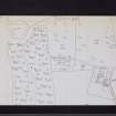
This site was recorded as part of the RCAHMS Emergency Survey, undertaken by Angus Graham and Vere Gordon Childe during World War 2. The project archive has been catalogued during 2013-2014 and the material, which includes notebooks, manuscripts, typescripts, plans and photographs, is now available online.
Information from RCAHMS (GF Geddes) 2 December 2014.
Excavation (1955)
Desk Based Assessment (30 August 1972)
(NS 0504 6397) Earthwork (R)
OS 6" map (1957)
The top of Cnoc-an-Dun is enclosed within a flattened earthen rampart, 120ft in diameter, with an external ditch visible on the N and E sides. Four hollows, which Hewison suggested were hut circles, were found to be slight irregular depressions in the hill slope on the NW. The best one, 14ft in diameter, was excavated in 1955, but no trace of occupation or of hut walls was found. Soil may have been removed from the area when making the rampart, so leaving the depression.
Information from OS (IF) 30 August 1972
J K Hewison 1893; D N Marshall 1963
Field Visit (2 November 1972)
Situated on the summit of a small steep-sided knoll are the remains of an enclosure. The single earthen bank, up to 2.0m wide, 1.0m high externally and 0.2m internally survives on the W, S and E sides only and encloses an area of 42.0m E-W by approx 32.0m transversely. There is no trace of an external ditch. The interior has several amorphous depressions, none of which, however, have the appearance of hut platforms. There are insufficient remains for it to be classified with any certainity; the site affords a good defensive position but the absence of any stonework would seem to indicate a pastoral rather than a defensive nature.
Surveyed at 1:2500.
Visited by OS (TRG) 2 November 1972
Field Visit (6 July 2009)
What is probably the remains of an enclosure survive on the top of this distinct natural hill, 160m NW of Craigandun. The hilltop is heavily obscured by gorse and long grass particularly on the N side and a stone dyke runs across the hill top from E-W. The NNE of the hill has been quarried and extensive quarries exist 100m to the W. The low enclosure bank is as previously described by the OS and is particularly clear where it runs under the stone dyke on the W side. The amorphous depressions within the enclosure are more difficult to interpret since the site has been partially excavated in 1955 by D N Marshall and volunteers. What is possibly a second inner bank is visible on the W and S sides.
Down hill or Dunalunt is depicted on May's maps (1781-2) on Ballycaul farm; the boundary with Dunalunt farm ran along the N foot of the hill and is now visible as a trackway. Hewison (1893, 45) described it thus: 'Dunallunt (Dun-allerd), or Cnoc-an-dune (342 feet), is a grass-grown hill, whose top is entirely enclosed within an earth-built fort, 120 feet in diameter. The steep slopes on the north and east sides are cut by a ditch, out of which an earthen fence has been raised, apparently as an outer defensive circumvallation. The earth wall on the wall is considerably flattened down. within the circle on the north side four hollows appear as if they indicated the sites of primitive houses'.The OS described the site in c.1863: 'a small but prominent hill the top of which has evidently been levelled by art, and consists of rich looking pasture at least differing much from the surrounding ground. The Rev. Alex. McBride and John Muir Esq. believe it to be one of the hill forts spoken of in the New Statistical Account. There is no tradition in the locality respecting it.' (Name Book No.6, 61). The site is depicted on the first and subsequent editions of the OS 6-inch map (Buteshire 1869, Sheet CCIV) with two encircling banks, one of c.45m diameter and one of c.25m diameter.
Visited by RCAHMS (GFG, PJD) 6 July 2009.

