Bute, Craigberoch
Cup Marked Stone (Neolithic) - (Bronze Age), Standing Stone (Neolithic) - (Bronze Age), Standing Stone (Prehistoric)
Site Name Bute, Craigberoch
Classification Cup Marked Stone (Neolithic) - (Bronze Age), Standing Stone (Neolithic) - (Bronze Age), Standing Stone (Prehistoric)
Alternative Name(s) Craig Biorach
Canmore ID 40383
Site Number NS06SE 19
NGR NS 07457 63648
Datum OSGB36 - NGR
Permalink http://canmore.org.uk/site/40383
- Council Argyll And Bute
- Parish North Bute
- Former Region Strathclyde
- Former District Argyll And Bute
- Former County Buteshire
NS06SE 19 07452 63652.
(NS 0745 6366) Standing Stone (NR)
OS 6" map (1957)
An 8ft high standing stone is situated 50yds SSE of Craigbiorach. Its SW face bears two cup-marks 26ins and 44 ins from the ground.
R W B Morris and D C Bailey 1967
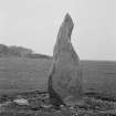
Situated in a level pasture field is a pointed and angular standing stone. It is 2.4m high, 0.9m at its broadest point and 0.4m thick. Its SW face bears three cup marks, at 0.7m, 1.5m and 1.9m above ground level.
Surveyed at 1:2500.
Visited by OS (TRG) 2 November 1976
This standing stone is as described by the OS. Graffiti on the NE side includes dates that are barely legible and the initials 'JS' and 'IP'.
Visited by RCAHMS (AGCH, JH) 22 April 2009.
Field Visit (May 1943)
This site was recorded as part of the RCAHMS Emergency Survey, undertaken by Angus Graham and Vere Gordon Childe during World War 2. The project archive has been catalogued during 2013-2014 and the material, which includes notebooks, manuscripts, typescripts, plans and photographs, is now available online.
Information from RCAHMS (GF Geddes) 2 December 2014.
Reference (4 July 1972)
(NS 0745 6366) Standing Stone (NR)
OS 6" map (1957)
An 8ft high standing stone is situated 50yds SSE of Craigbiorach. Its SW face bears two cup-marks 26ins and 44 ins from the ground.
Information from OS (IF) 4 July 1972
ref: R W B Morris and D C Bailey 1967
Field Visit (2 November 1976)
Situated in a level pasture field is a pointed and angular standing stone. It is 2.4m high, 0.9m at its broadest point and 0.4m thick. Its SW face bears three cup marks, at 0.7m, 1.5m and 1.9m above ground level.
Surveyed at 1:2500.
Visited by OS (TRG) 2 November 1976
Sketch Drawing (2005)
Field Visit (22 August 2009)
This standing stone is as described by the OS. Graffiti on the NE side includes dates that are barely legible and the initials 'JS' and 'IP'.
Visited by RCAHMS (AGCH, JH) 22 April 2009.
Note (31 May 2020)
Date Fieldwork Started: 31/05/2020
Compiled by: Rock Art Bute
Location Notes: This prominent standing stone is situated in a level boggy area of rough grazing, surrounded by rushes and gorse. It lies approximately 40m SW of the farm steading and a power line pole, and due S of a burial cairn From the standing stone the view WSW is to Barone Hill.
Panel Notes: The standing stone is a roughly triangular schist slab, measuring 2.3m high x 1.12m wide, with a thickness of 0.3m. It is wide at the base and tapers to a point at its tip. The carved surface faces SW but may be on a different orientation from its original setting as a local farmer noted that the stone was accidentally knocked over . On the vertical SW face there are 3 cupmarks, on the NE face there is graffiti carved in two rectangles, possibly PB and IP. Prominent grooves can be seen running at 45 degrees across the N face, which may relate to when it was re-erected.


