
Bute, The Cauldron


Enclosure (Period Unassigned)
Site Name Bute, The Cauldron
Classification Enclosure (Period Unassigned)
Alternative Name(s) Devil's Cauldron, St Blane's
Canmore ID 40295
Site Number NS05SE 8
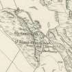
NGR NS 09430 53523
Datum OSGB36 - NGR
Permalink http://canmore.org.uk/site/40295


- Council Argyll And Bute
- Parish Kingarth
- Former Region Strathclyde
- Former District Argyll And Bute
- Former County Buteshire
NS05SE 8 09430 53523.
NS 0943 5350. The Cauldron (NR)
OS 6" map (1957)
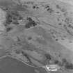
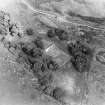
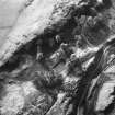
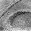
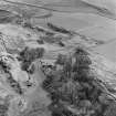
The Devil's Cauldron (J K Hewison 1893) or The Cauldron (DoE) is classified by Cruden as a "ring-fort" of late Iron Age or Dark Age date. It is situated beneath a precipitous ridge 70ft high. Its wall, composed of massive drystone blocks was about 5ft high and 8ft thick in 1960 enclosing an oval area 33ft 7ins x 31ft. The entrance in the SSE, is 4ft broad, and narrows as it reaches the interior. It is not unlikely that this was the fort of the chieftain who, in about the sixth century, gave land and perhaps the fort itself to the new monastery.
S Cruden 1960
The Devil's Cauldron, a curious circular structure of huge stones is certainly earlier than St Blan's Chapel and monastery (6th century - NS05SE 5) but its purpose has never been satisfactorily explained.
D N Marshall 1974
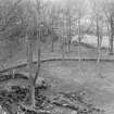
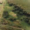
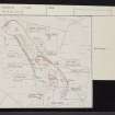
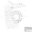
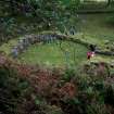
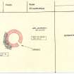
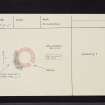
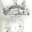
"The Cauldron" (name confirmed) is a near-circular enclosure situated at the foot of an east-facing cliff and enclosed within the main cashel wall of the settlement of St Blanes. It measures 10.0m NE-SW by 9.3m transversely within a double-faced wall 2.5m thick and standing to a maximum height of 1.8m. The entrance, in the SE, narrows from 2.5, wide on the outside to 1.6m wide, and shows no evidence of a door check. The wall at this point is splayed to 3.0m.
The origin and use of "the Cauldron" is conjectural; however its position at the foot of a near vertical 70ft high rock face suggests that it is not a defensive work such as a dun or "ring fort" and its wall thickness in relation to the internal diameter precludes its classification as a broch. It seems likely to be an occupational structure contemporary with the monastic establishment (NS05SE 5).
Surveyed at 1:10 000.
Visited by OS (BS) 10 November 1976
This site is generally as described. There has been a substantial amount of reconstruction of the wall and the interior of the enclosure is up to 0.8m higher than the surrounding land surface.
Visited by RCAHMS (AGCH, IP) 18 March 2009.
Reference (1774)
Reference (1820)
Reference (1840)
'A grove...contains a remarkable kind of building, of which the use remains altogether unknown. This consists of a wall, forming a complete circle 30 feet in diameter; rising to 10 feet in height above the ground, and obviously filled with rubbish to some depth; 9 feet thick, and having a passage 9 feet wide. The erection was doubtless formed with a view to great strength. It is composed of rude stones, many of them of immense size. The workmanship seems to be of a more remote date than that of any part of the adjacent ruins; but its evident communication with these, shown by marks still remaining, would indicate, its having been connected with them, for whatever purpose. It is situated at the foot of a ridge of rock, running from north to south, 50 feet high, and forming at each end a junction with an outer wall, which marked, it is probable, the sacred precincts.’
J Buchanan 1840, NSA
Reference (1893)
Measured Survey (1896)
Field Visit (25 May 1943)
This site was included within the RCAHMS Emergency Survey (1942-3), an unpublished rescue project. Site descriptions, organised by county, vary from short notes to lengthy and full descriptions and are available to view online with contemporary sketches and photographs. The original typescripts, manuscripts, notebooks and photographs can also be consulted in the RCAHMS Search Room.
Information from RCAHMS (GFG) 10 December 2014.
Photographic Record (1961)
Reference (19 July 1972)
The Devil's Cauldron (J K Hewison 1893) or The Cauldron (DoE) is classified by Cruden as a "ring-fort" of late Iron Age or Dark Age date. It is situated beneath a precipitous ridge 70ft high. Its wall, composed of massive drystone blocks was about 5ft high and 8ft thick in 1960 enclosing an oval area 33ft 7ins x 31ft. The entrance in the SSE, is 4ft broad, and narrows as it reaches the interior. It is not unlikely that this was the fort of the chieftain who, in about the sixth century, gave land and perhaps the fort itself to the new monastery.
Information from OS (IF) 19 July 1972
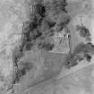
Aerial Photography (1973)
Oblique aerial photographs of St Balne's Church and burial ground, Bute, by Mr John Dewar in 1973.
Field Visit (10 November 1976)
"The Cauldron" (name confirmed) is a near-circular enclosure situated at the foot of an east-facing cliff and enclosed within the main cashel wall of the settlement of St Blanes. It measures 10.0m NE-SW by 9.3m transversely within a double-faced wall 2.5m thick and standing to a maximum height of 1.8m. The entrance, in the SE, narrows from 2.5, wide on the outside to 1.6m wide, and shows no evidence of a door check. The wall at this point is splayed to 3.0m.
The origin and use of "the Cauldron" is conjectural; however its position at the foot of a near vertical 70ft high rock face suggests that it is not a defensive work such as a dun or "ring fort" and its wall thickness in relation to the internal diameter precludes its classification as a broch. It seems likely to be an occupational structure contemporary with the monastic establishment (NS05SE 5).
Surveyed at 1:10 000.
Visited by OS (BS) 10 November 1976
Reference (10 November 1976)
The Devil's Cauldron, a curious circular structure of huge stones is certainly earlier than St Blane's Chapel and monastery (6th century - NS05SE 5) but its purpose has never been satisfactorily explained.
Information from OS (BS) 10 November 1976
Reference (1997)
Field Visit (18 March 2009)
This site is generally as described. There has been a substantial amount of reconstruction of the wall and the interior of the enclosure is up to 0.8m higher than the surrounding land surface.
Visited by RCAHMS (AGCH, IP) 18 March 2009.
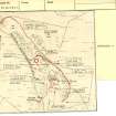
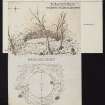
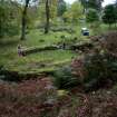
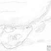
Measured Survey (15 October 2010 - 25 October 2010)
RCAHMS surveyed the enclosure at ‘The Cauldron’, Bute between 15-25 October 2010 with a local volunteer. The survey, undertaken using plane table and alidade, produced a plan and section of the site at a scale of 1:100.
Note (June 2017)
What is Cenn Garah and how has it changed over time?
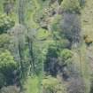
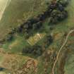
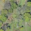
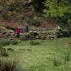
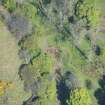
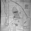
A Google view of the monastic site shows that it sits in a green glen, with a wooded cliff on the west side and is surrounded by a thick wall around the north and east sides. This wall is known as the ‘cashel’. This wall would have separated the spiritual ground from the everyday, secular world. Within the spiritual space are a series of buildings, walled burial grounds and other features that can help us construct a story of the life of Cenn Garah.
If you get the chance to visit St Blane’s you will approach the site from the southern end, whereas the monastic population would have used a gateway through the cashel wall on the east side. A carved stone was found next to this gateway, which is believed to have been the base of a tall carved stone cross that would have welcomed the members to the monastic community.
Today the main features of the site, within the cashel, are the 12th century, roofless church, which sits inside an oval burial ground. The burial enclosure walls are at least 2m high above the ground, presumably as a result of the accumulation of burials. The burial ground is built over two levels: the upper level was traditionally used for male burials where the lower ground level was used for females. The upper burial ground was still being used until the 12th century church was built.
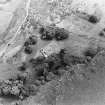
To the north of the church are a number of features tucked in at the foot of the cliff. To the south is a later building, which was initially the manse and subsequently used as a farm building.
As you wander around the quiet location, which is sheltered from the south-westerly weather by the landscape, you begin to see bits of walling built into the foot of the cliff. Perhaps some of these are the remains of the monastic settlement?
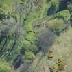
Towards the north end of the site is a circular building, known as the ‘Cauldron’. This very unusual structure may have been a part of an earlier period of occupation, before Christianity came to Bute. One suggestion is that it was an Iron Age building that was later re-used and modified by the monastic settlers. Perhaps it was a space designated for contemplation and retreat?
The re-creation of St Blane’s since the 1890s
The third Marquess of Bute was interested in history and spent time and money conserving some of Bute’s ancient sites, including St Blane’s. Under the guidance of the architect R.W.Schultz, the Marquess’s gardeners and estate labourers rebuilt much of the cashel wall, parts of the church and the enclosing walls of the burial ground. The present day remains of St Blane’s is as a result of this period of re-building, conserving and tidying up of the landscape within the cashel.
Today, this landscape is cared for by Historic Environment Scotland. The grass is regularly mowed, there is signage to help the casual visitor understand some of the features and the stonework of the various buildings and structures is maintained. So the landscape is one which has undergone many changes and is quite different from when the monastery was first established. But if you do get to visit, you may get a glimpse of why such a secluded, tranquil place was chosen as the place to establish a monastery for quiet, contemplation; something that perhaps we all aspire to occasionally, to take us away from our 24 hour, social media-driven lives.
Dr Alex Hale - Archaeology Projects Manager

