
Pricing Change
New pricing for orders of material from this site will come into place shortly. Charges for supply of digital images, digitisation on demand, prints and licensing will be altered.
Upcoming Maintenance
Please be advised that this website will undergo scheduled maintenance on the following dates:
Thursday, 9 January: 11:00 AM - 3:00 PM
Thursday, 23 January: 11:00 AM - 3:00 PM
Thursday, 30 January: 11:00 AM - 3:00 PM
During these times, some functionality such as image purchasing may be temporarily unavailable. We apologise for any inconvenience this may cause.
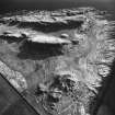
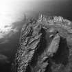
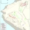
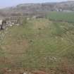
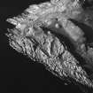
Bute, Little Dunagoil


Cist (Period Unassigned)
Site Name Bute, Little Dunagoil
Classification Cist (Period Unassigned)
Canmore ID 40294
Site Number NS05SE 7
NGR NS 08598 53226
Datum OSGB36 - NGR
Permalink http://canmore.org.uk/site/40294


- Council Argyll And Bute
- Parish Kingarth
- Former Region Strathclyde
- Former District Argyll And Bute
- Former County Buteshire
Reference (1880)
Reference (1893)
Reference (1904)
Field Visit (1915)
Field Visit (25 May 1943)
This site was recorded as part of the RCAHMS Emergency Survey, undertaken by Angus Graham and Vere Gordon Childe during World War 2. The project archive has been catalogued during 2013-2014 and the material, which includes notebooks, manuscripts, typescripts, plans and photographs, is now available online.
Information from RCAHMS (GF Geddes) 2 December 2014.
Excavation (1968 - 1969)
Desk Based Assessment (31 August 1972)
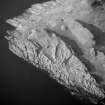
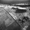
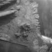
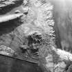
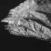
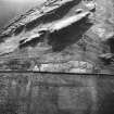
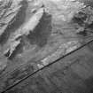
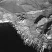
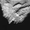
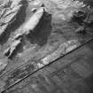
NS 086 532. A megalithic structure, presumably a ruined burial chamber, lies at the foot of the NE slope of Little Dunagoil. It was excavated in 1968-9 by Miss D N Marshall. Four massive slabs seem to have formed a burial chamber, now lacking a capstone. Beyond the E side is a recumbant slab which may have been part of the structure. The present maximum length is about 4ft 6ins. The width and height are 3ft. The structure presumably had a supporting cairn, and some of this may survive, as shown on plan. No finds were made. Possibly this structure is protomegalith, though it could be merely a Bronze Age cist, erected above ground because of the difficulty of digging in the rocky ground.
Information from OS (IF) 31 August 1972
J G Scott 1969.
Field Visit (22 November 1976)
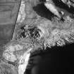
NS 0859 5322. The remains of a burial chamber generally as planned and described by the previous authority and measuring 1.5m by 1.2m by 0.8m high. The small scatter of grass-covered stones around the chamber may be all that survives of an original cairn at this site. There is a recumbent slab 1.3m long, 0.6m wide and 0.1m thick lying just to the W but its relationship to the chamber cannot be established.
Surveyed at 1:10 000.
Visited by OS (B S) 22 November 1976.
Reference (2004)
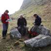
Field Visit (20 March 2009)
This cist or burial chamber is as described by previous authorities. The monument may have been known to J Blain, writing in the early 19th century, who noted that some small cairns and barrows 'within the Dunagoil fort' were excavated under his request by J Norton, head gardener at Mount Stuart. This resulted in him finding ‘undoubted evidence of their having been places of sepulchre’ (1880, 78), something noted by later authors (Hewison 1893, 38; Bryce 1903, 70). The position of the cist was accurately recorded for the first time on a plan of the archaeological sites around Dunagoil by D Dewar, published in J N Marshall's summary in 1915. However, the locational informational given in the text is incorrect (Marshall 1915, 44). Since then, it has been depicted on OS maps and it was visited in 1943 by A Graham as part of the Emergency Survey undertaken by RCAHMS. The interior of the structure was excavated by D N Marshall in 1968 and 1969, and the results were published by J Scott (1969, 36-37).
Visited by RCAHMS (GFG, AGCH, ARG, IP) 20 March 2009.

