
Pricing Change
New pricing for orders of material from this site will come into place shortly. Charges for supply of digital images, digitisation on demand, prints and licensing will be altered.
Upcoming Maintenance
Please be advised that this website will undergo scheduled maintenance on the following dates:
Thursday, 9 January: 11:00 AM - 3:00 PM
Thursday, 23 January: 11:00 AM - 3:00 PM
Thursday, 30 January: 11:00 AM - 3:00 PM
During these times, some functionality such as image purchasing may be temporarily unavailable. We apologise for any inconvenience this may cause.
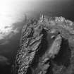
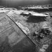
Bute, Dunagoil


Clearance Cairn(S) (Period Unknown)
Site Name Bute, Dunagoil
Classification Clearance Cairn(S) (Period Unknown)
Canmore ID 40281
Site Number NS05SE 15
NGR NS 0869 5308
NGR Description Centred NS 0869 5308
Datum OSGB36 - NGR
Permalink http://canmore.org.uk/site/40281


- Council Argyll And Bute
- Parish Kingarth
- Former Region Strathclyde
- Former District Argyll And Bute
- Former County Buteshire
NS05SE 15 centred 0869 5308.
(NS 0869 5308) Mound (NR).
OS 25" map, (1899)
This feature is a small, evidently artificial mound of earth, resembling a tumulus. It is believed by Messrs Grant (schoolmaster) and Muir (Barone Park) that it is sepulchral, but Mr McGomerie states that this is traditionally thought to be a place where beacon fires were lit. (See also NS05SE 13).
Name Book 1863.
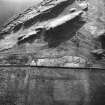
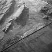
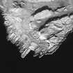
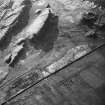
NS 0869 5308 At this site is a group of about a dozen field clearance heaps occupying an area of 0.05 hectares; there is no trace of either hut circles or fields to be seen. The largest of these heaps is 5.0m in diameter and 0.6m high and is probably the mound referred to in the previous information. This clearance is bounded on the E by a mediaeval field wall (see NS05SE 14) which may be contemporary.
Visited by OS (B S) 10 November 1976.
This site is as previously described by the Ordnance Survey.
Visited by RCAHMS (GFG) 20 March 2009.
Desk Based Assessment (2 July 1976)
This feature is a small, evidently artificial mound of earth, resembling a tumulus. It is believed by Messrs Grant (schoolmaster) and Muir (Barone Park) that it is sepulchral, but Mr McGomerie states that this is traditionally thought to be a place where beacon fires were lit. (See also NS05SE 13).
Information from OS (IF) 2 July 1976
Name Book 1863.
Field Visit (10 November 1976)
NS 0869 5308 At this site is a group of about a dozen field clearance heaps occupying an area of 0.05 hectares; there is no trace of either hut circles or fields to be seen. The largest of these heaps is 5.0m in diameter and 0.6m high and is probably the mound referred to in the previous information. This clearance is bounded on the E by a mediaeval field wall (see NS05SE 14) which may be contemporary.
Visited by OS (B S) 10 November 1976.
Field Visit (20 March 2009)
This site is as previously described by the Ordnance Survey.
Visited by RCAHMS (GFG) 20 March 2009.

