|
Photographs and Off-line Digital Images |
C 9521 |
RCAHMS Aerial Photography |
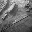
Oblique aerial view of Dunagoil fort and Little Dunagoil (top left), showing cultivation remains, cist, and field boundaries, taken from W. |
1993 |
Item Level |
|
|
Photographs and Off-line Digital Images |
C 9527 |
RCAHMS Aerial Photography |
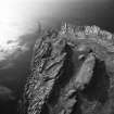
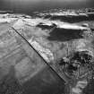
Oblique aerial view showing forts, cist (at centre right), cultivation remains and field clearance cairns, taken from N. |
1993 |
Item Level |
|
|
Photographs and Off-line Digital Images |
C 9524 |
RCAHMS Aerial Photography |
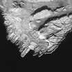
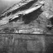
Oblique aerial view. |
1993 |
Item Level |
|
|
Photographs and Off-line Digital Images |
C 9526 |
RCAHMS Aerial Photography |
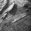
Oblique aerial view showing fort, cist, field clearance cairns, structures and rig, taken from E. |
1993 |
Item Level |
|
|
Photographs and Off-line Digital Images |
C 9525 |
RCAHMS Aerial Photography |
General oblique view, taken from the SE. |
1993 |
Item Level |
|
 |
On-line Digital Images |
SC 1207479 |
RCAHMS Aerial Photography |
General oblique view, taken from the SE. |
1993 |
Item Level |
|
 |
On-line Digital Images |
SC 1723954 |
RCAHMS Aerial Photography |
Oblique aerial view of Dunagoil fort and Little Dunagoil (top left), showing cultivation remains, cist, and field boundaries, taken from W. |
1993 |
Item Level |
|
 |
On-line Digital Images |
SC 1723957 |
RCAHMS Aerial Photography |
Oblique aerial view. |
1993 |
Item Level |
|
 |
On-line Digital Images |
SC 1723958 |
RCAHMS Aerial Photography |
General oblique view, taken from the SE. |
1993 |
Item Level |
|
 |
On-line Digital Images |
SC 1723959 |
RCAHMS Aerial Photography |
Oblique aerial view showing fort, cist, field clearance cairns, structures and rig, taken from E. |
1993 |
Item Level |
|
 |
On-line Digital Images |
SC 1723960 |
RCAHMS Aerial Photography |
Oblique aerial view showing forts, cist (at centre right), cultivation remains and field clearance cairns, taken from N. |
1993 |
Item Level |
|
 |
On-line Digital Images |
SC 2420246 |
Records of the Ordnance Survey, Southampton, Hampshire, England |
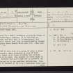
Bute, Dunagoil, NS05SE 15, Ordnance Survey index card, page number 1, Recto |
1958 |
Item Level |
|
 |
On-line Digital Images |
SC 2420247 |
Records of the Ordnance Survey, Southampton, Hampshire, England |
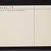
Bute, Dunagoil, NS05SE 15, Ordnance Survey index card, page number 2, Verso |
1958 |
Item Level |
|
|
All Other |
551 166/1/1 |
Records of the Ordnance Survey, Southampton, Hampshire, England |
Archaeological site card index ('495' cards) |
1947 |
Sub-Group Level |
|


