
Bute, Scalpsie


Building (Period Unassigned)(Possible), Burial Cairn (Period Unassigned), Cist (Period Unassigned)(Possible)
Site Name Bute, Scalpsie
Classification Building (Period Unassigned)(Possible), Burial Cairn (Period Unassigned), Cist (Period Unassigned)(Possible)
Canmore ID 40259
Site Number NS05NE 9
NGR NS 05744 58676
Datum OSGB36 - NGR
Permalink http://canmore.org.uk/site/40259


- Council Argyll And Bute
- Parish North Bute
- Former Region Strathclyde
- Former District Argyll And Bute
- Former County Buteshire
NS05NE 9 05744 58676.
(NS 0575 5867) Cairn (NR).
OS 6" map, (1957)
This was a large stone cairn. It was removed about 50 years ago, to cultivate the land, but when almost demolished, a cist was found, so work was stopped.
Name Book c.1863
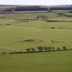
The position of this cairn in a pasture field can now only be established by an area of rough uncultivated ground covered with modern field clearance. There are no identifiable features in this approximately 22.0m diameter 'stoney path' except for a large slab near the centre; this is 2.0m long by 0.8m wide and 0.2m thick and rests on small stones but it does not appear to be a cist cover.
Surveyed at 1:10 000.
Visited by OS (B S) 29 October 1976
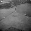
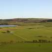
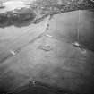
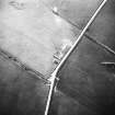
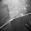
This cairn is situated in an arable field 270m S of Scalpsie farmsteading. It has been very heavily robbed and it is not now possible to distinguish its perimeter within an irregularly-shaped stony area measuring about 46m from NE to SW by 32m transversely. On the NW side of this area, amongst stones and boulders that have been cleared off the surrounding field, is a vertically set slab which may be part of a cist, possibly the one described around 1863 (OS Name Book, Buteshire No.7, p.92). A large hollow, measuring about 8m across, which has been cut into in the SW edge of the cairn may represent the remains of a building.
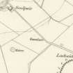
The area in which the cairn lies is depicted as an irregularly-shaped uncultivated patch of grass surrounded by arable fields on May's estate map of Scalpsie and Quien farms, dated 1781. The cairn is identified and depicted on the 1st edition of the Ordnance Survey 6-inch map (Buteshire 1869, sheet CCXV).
Visited by RCAHMS (AGCH) 6 May 2009.
Antiquarian Mapping (1780 - 1782)
Reference (1893)
Field Visit (27 May 1943)
This site was included within the RCAHMS Emergency Survey (1942-3), an unpublished rescue project. Site descriptions, organised by county, vary from short notes to lengthy and full descriptions and are available to view online with contemporary sketches and photographs. The original typescripts, manuscripts, notebooks and photographs can also be consulted in the RCAHMS Search Room.
Information from RCAHMS (GFG) 10 December 2014.
Desk Based Assessment (7 July 1972)
This was a large stone cairn. It was removed about 50 years ago, to cultivate the land, but when almost demolished, a cist was found, so work was stopped.
Name Book c.1863.
Field Visit (29 October 1976)
The position of this cairn in a pasture field can now only be established by an area of rough uncultivated ground covered with modern field clearance. There are no identifiable features in this approximately 22.0m diameter 'stoney path' except for a large slab near the centre; this is 2.0m long by 0.8m wide and 0.2m thick and rests on small stones but it does not appear to be a cist cover.
Surveyed at 1:10 000.
Visited by OS (B S) 29 October 1976.
Field Visit (6 May 2009)
This cairn is situated in an arable field 270m S of Scalpsie farmsteading. It has been very heavily robbed and it is not now possible to distinguish its perimeter within an irregularly-shaped stony area measuring about 46m from NE to SW by 32m transversely. On the NW side of this area, amongst stones and boulders that have been cleared off the surrounding field, is a vertically set slab which may be part of a cist, possibly the one described around 1863 (OS Name Book, Buteshire No.7, p.92). A large hollow, measuring about 8m across, which has been cut into in the SW edge of the cairn may represent the remains of a building.
The area in which the cairn lies is depicted as an irregularly-shaped uncultivated patch of grass surrounded by arable fields on May's estate map of Scalpsie and Quien farms, dated 1781. The cairn is identified and depicted on the 1st edition of the Ordnance Survey 6-inch map (Buteshire 1869, sheet CCXV).
Visited by RCAHMS (AGCH) 6 May 2009.
Measured Survey (2009 - 2010)
A series of measured drawings undertaken as part of ACFA's CARES project.
Publication Account (2009)
The position of the cairn, its sheer size and the large stones found within the body of the cairn are part of the reason why it has not been entirely removed by agricultural agencies. The location of the cairn is depicted on the May map of 1784, showing an area of ‘grass’, amongst ploughed fields.
The Ordnance Survey Name Book (1895) for the parish of Rothesay contains an entry for this cairn which states:
Relative to the tumulus so far
as I am informed by Mr Muir
of Mecknock, it had been a
large cairn of stones, and was
removed by his father in law
about 50 years ago for the
sake of cultivating it, but a
stone cist being found in it
when almost demolished it
was let alone and has never
yet been ploughed, the
evidence on the ground is
quite distinct.
The size of the cairn and the large boulders concentrated towards the north east side may suggest that this was a chambered cairn. Some judicious clearing of stones, or a small excavation, which could be undertaken as part of the DBLPS community archaeology project, would probably be required to resolve the question. Record enhancement might include adding images such as the kite photograph of the site taken by John and Rosie Wells, from Armadale Historical Society.
The RCAHMS database description is as follows:
NS05NE 9
This was a large stone cairn. It was removed about 50 years ago, to cultivate the land, but when almost demolished, a cist was found, so work was stopped. Name Book 1895.
The position of this cairn in a pasture field can now only be established by an area of rough uncultivated ground covered with modern field clearance.There are no identifiable features in this approximately 22.0m diameter 'stoney path’ except for a large slab near the centre; this is 2.0m long by 0.8m wide and 0.2m thick and rests on small stones but it does not appear to be a cist cover.
Surveyed at 1:10 000.
Visited by OS (B S) 29 October 1976.
Information from ‘The Royal Commission on the Ancient and Historical Monuments of Scotland, Commissioners’ Field Meeting 2009'.
Field Visit (2009 - 2010)
This very ruinous cairn was noted in an OS Object Name Book of around 1863 (Ordnance Survey 1863). The note reads:
‘This was a large stone cairn. It was removed about 50 years ago, to cultivate the land, but when almost demolished, a cist was found, so work was stopped.’
The following account of its present condition has been supplied by Scott Wood, who also produced the plan of the site.
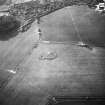
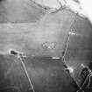
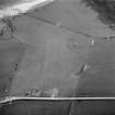
The cairn lies on the W side of a wide grassy field bounded by the A844 road on the NE. The whole complex is roughly oval in shape, being some 50m from NE to SW and 35m from NW to SE. The land slopes gently from NE to SW with the feature appearing on a level ‘platform’ starting at field level in the N but with increasing slopes on the E and W flanks to a height of some 1.30m at the S side.
At the S end, beyond the platform, is a crescent-shaped bank 14m long from N to S with an abundance of stones at the S end. Reports indicate that excavations took place in the 19th century and this crescent bank is presumed to be the main spoil heap to which field clearance has been added. Eight metres to the E further field clearance has been deposited on the rim of the platform at its southern end.
Disregarding the crescent spoil heap S of the complex, the platform is circular in shape at 35m along both axes. There is no evidence that the platform or base is artificial, but equally the landform around does not suggest a natural outcrop.
On the platform is a raised mound of scattered stones some 22m long from E to W and around 10m wide from N to S. The mound is 1.2m high at best and has a sloping profile at its E end.
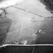
The western third of the mound is much disturbed and is likely to have been the focus of previous explorations. At the western end of the disturbed area are a number of large stone slabs varying from a metre to two metres in length. On the N side are two large slabs, one of which is 2.40m long, both in association with small pits up to 0.50m deep and up to 1.0m long. The two pits, one still partly covered by a slab, are suggestive of cists or chambers.
At the eastern end just above the slope of the mound is a small round cairn of stones 2.50m in diameter, probably dumped stones from nearby previous excavations. Another heap 5.0m long to the N of the ‘cists’ is also a possible spoil heap while to the S is a 7.0m long scatter of stones, probably too heavy to fully remove.
In conclusion: this may well have been a cairn with an architectural façade at the SW and a passage to a chamber towards the E that is no longer visible. The two pits in the N with associated slabs are probably later cist insertions into the cairn. The feature is much degraded and large quantities of the original material are missing.
Project (5 June 2010 - 12 June 2010)
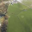
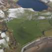
An integrated geophysical survey was conducted in an area with a burial cairn (NS05NE 9) and a barrow (NS05NE 10) at Scalpsie Bay 5–12 June 2010. The general aim was to gain a better understanding of these structures, to collate data for a PhD research project and to help in the planning of an excavation at the barrow by the DBLPS (DES 2010, 49).
An extensive magnetic gradiometer survey was undertaken to determine the extent of the cairns and any other features. The survey was carried out at 0.5 x 0.13m intervals covering 3.56ha. Targeted magnetic susceptibility, earth resistance and ground penetrating radar surveys were carried out over the burial cairn to clarify its current shape and depth.
The gradiometer survey mapped the two cairns and their immediate environs. The detected remains of the burial cairn measured c 37m E–W, 33m N–S and 48m NE–SW. The dimensions of the barrow were c15m N–S by 16m NE–SW. The presence of a metal fence to the E of the barrow prevented a full survey in that direction.
The multi-technique geophysical survey revealed anomalies associated with the cairns. Distinctive dipolar anomalies were detected in front of a possible entrance and surrounding the burial cairn. Low resistance anomalies around the burial cairn suggest a possible truncated ditch. Other trends and circular anomalies were detected inside the burial cairn. The GPR data recorded reflections of interest underlying the structure to a depth of 1m. The survey also detected features related to historical periods (eg old field boundaries and evidence of cultivation marks) as well as areas of disturbance in the burial cairn and geological features within the surveyed area. No remains suggesting the presence of the building which is mentioned in the RCAHMS database were identified.
Archive: DBLPS project (deposited) and RCAHMS (intended)
Funder: NERC and Discover Bute Landscape Partnership Scheme
University of Glasgow 2010
Magnetic Susceptibility (5 June 2010 - 12 June 2010)
Targeted magnetic susceptibility survey carried out over the burial cairn to clarify its current shape and depth.
Archive: DBLPS project (deposited) and RCAHMS (intended)
Funder: NERC and Discover Bute Landscape Partnership Scheme
University of Glasgow 2010
Ground Penetrating Radar (5 June 2010 - 12 June 2010)
Ground Penetrating Radar was conducted in an area with a burial cairn (NS05NE 9) and a barrow (NS05NE 10) at Scalpsie Bay 5–12 June 2010.
Archive: DBLPS project (deposited) and RCAHMS (intended)
Funder: NERC and Discover Bute Landscape Partnership Scheme
University of Glasgow 2010
Earth Resistance Survey (5 June 2010 - 12 June 2010)
A resistance survey was conducted in an area with a burial cairn (NS05NE 9) and a barrow (NS05NE 10) at Scalpsie Bay 5–12 June 2010.
Archive: DBLPS project (deposited) and RCAHMS (intended)
Funder: NERC and Discover Bute Landscape Partnership Scheme
University of Glasgow 2010
Magnetometry (5 June 2010 - 12 June 2010)
A gradiometer survey was conducted in an area with a burial cairn (NS05NE 9) and a barrow (NS05NE 10) at Scalpsie Bay 5–12 June 2010.
Archive: DBLPS project (deposited) and RCAHMS (intended)
Funder: NERC and Discover Bute Landscape Partnership Scheme
University of Glasgow 2010

