|
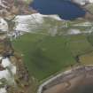
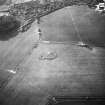
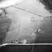
Photographs and Off-line Digital Images |
C 9551 |
RCAHMS Aerial Photography |
Oblique aerial view. |
1993 |
Item Level |
|
|
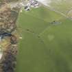
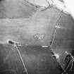
Photographs and Off-line Digital Images |
C 9552 |
RCAHMS Aerial Photography |
Oblique aerial view. |
1993 |
Item Level |
|
|
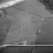
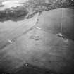
Photographs and Off-line Digital Images |
C 9553 |
RCAHMS Aerial Photography |
Oblique aerial photograph taken from the north-east. |
1993 |
Item Level |
|
|
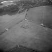
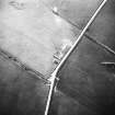
Photographs and Off-line Digital Images |
C 9550 |
RCAHMS Aerial Photography |
Oblique aerial photograph taken from the east. |
1993 |
Item Level |
|
|
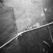
Photographs and Off-line Digital Images |
C 9549 |
RCAHMS Aerial Photography |
Oblique aerial view. |
1993 |
Item Level |
|
|
Photographs and Off-line Digital Images |
C 9555 |
RCAHMS Aerial Photography |
Oblique aerial view. |
1993 |
Item Level |
|
 |
On-line Digital Images |
DP 062656 |
RCAHMS Aerial Photography Digital |
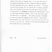
General oblique aerial view centred on the remains of the cairn with the remains of the dun adjacent, taken from the SW. |
6/2/2009 |
Item Level |
|
 |
On-line Digital Images |
DP 062682 |
RCAHMS Aerial Photography Digital |
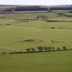
Oblique aerial view centred on the remains of the cairn with the remains of the dun adjacent, taken from the S. |
6/2/2009 |
Item Level |
|
 |
On-line Digital Images |
SC 1152230 |
RCAHMS Aerial Photography |
Oblique aerial photograph taken from the north-east. |
1993 |
Item Level |
|
 |
On-line Digital Images |
SC 1152236 |
RCAHMS Aerial Photography |
Oblique aerial photograph taken from the east. |
1993 |
Item Level |
|
 |
On-line Digital Images |
SC 1173033 |
Records of the Royal Commission on the Ancient and Historical Monuments of Scotland (RCAHMS), Edinbu |
Site description |
1943 |
Item Level |
|
 |
On-line Digital Images |
DP 077720 |
RCAHMS Field Survey Digital Photography |
General view of Scalpsie, taken from SW. |
9/12/2008 |
Item Level |
|
 |
On-line Digital Images |
SC 1173998 |
|
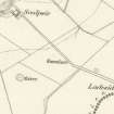
Extract of the 1st edition OS map, 1869. |
19/11/2009 |
Item Level |
|
 |
On-line Digital Images |
DP 083916 |
RCAHMS Field Survey Digital Photography |
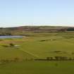
General view of the area between Scalpsie bay and Quien Loch, taken from the NW. |
9/12/2008 |
Item Level |
|
 |
On-line Digital Images |
SC 1723969 |
RCAHMS Aerial Photography |
Oblique aerial view. |
1993 |
Item Level |
|
 |
On-line Digital Images |
SC 1723970 |
RCAHMS Aerial Photography |
Oblique aerial photograph taken from the east. |
1993 |
Item Level |
|
 |
On-line Digital Images |
SC 1723971 |
RCAHMS Aerial Photography |
Oblique aerial view. |
1993 |
Item Level |
|
 |
On-line Digital Images |
SC 1723972 |
RCAHMS Aerial Photography |
Oblique aerial view. |
1993 |
Item Level |
|
 |
On-line Digital Images |
SC 1723973 |
RCAHMS Aerial Photography |
Oblique aerial photograph taken from the north-east. |
1993 |
Item Level |
|
 |
On-line Digital Images |
SC 1723975 |
RCAHMS Aerial Photography |
Oblique aerial view. |
1993 |
Item Level |
|
 |
On-line Digital Images |
SC 2420112 |
Records of the Ordnance Survey, Southampton, Hampshire, England |
Bute, Scalpsie, NS05NE 9, Ordnance Survey index card, page number 1, Recto |
c. 1958 |
Item Level |
|
 |
On-line Digital Images |
SC 2420113 |
Records of the Ordnance Survey, Southampton, Hampshire, England |
Bute, Scalpsie, NS05NE 9, Ordnance Survey index card, Recto |
c. 1958 |
Item Level |
|
|
All Other |
551 166/1/1 |
Records of the Ordnance Survey, Southampton, Hampshire, England |
Archaeological site card index ('495' cards) |
1947 |
Sub-Group Level |
|


