Bute, Largizean
Standing Stone(S) (Prehistoric)
Site Name Bute, Largizean
Classification Standing Stone(S) (Prehistoric)
Canmore ID 40257
Site Number NS05NE 7
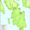
NGR NS 08465 55361
Datum OSGB36 - NGR
Permalink http://canmore.org.uk/site/40257
- Council Argyll And Bute
- Parish Kingarth
- Former Region Strathclyde
- Former District Argyll And Bute
- Former County Buteshire
NS05NE 7 08465 55361.
(NS 0846 5536) Standing Stones (NR)
OS 6" map, (1957)
Three large whinstone boulders stand in a line on Largizean farm. About 10ft apart, they measure respectively 5ft 2ins high by 4ft 2ins broad, 5ft 6ins by 3ft 4ins and 7ft 3ins by 4ft 10ins.
J K Hewison 1893.
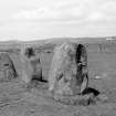
Three standing stones, 3.5 metres apart, stand on a line running NW-SE. From the NW they measure 1.5m high by 1.3m by 0.8m, 1.7m high by 1m by 1m, and 1.9m high by 1.6m by 1.2m.
Surveyed at 1/2500.
Visited by OS (B S) 25 October 1976.
These three standing stones, which are situated in the corner of a cultivated field, 500m NW of Largizean farmsteading, are as described by RCAHMS (Emergency Survey) in 1943 and the Ordnance Survey in 1976. Three standing stones are depicted on the 1st edition of the Ordnance Survey 6-inch map (Buteshire 1869, sheet CCXV).
Visited by RCAHMS (AGCH, JH) 5 May 2009.
Field Visit (27 May 1943)
This site was recorded as part of the RCAHMS Emergency Survey, undertaken by Angus Graham and Vere Gordon Childe during World War 2. The project archive has been catalogued during 2013-2014 and the material, which includes notebooks, manuscripts, typescripts, plans and photographs, is now available online.
Information from RCAHMS (GF Geddes) 2 December 2014.
Reference (10 July 1972)
Three large whinstone boulders stand in a line on Largizean farm. About 10ft apart, they measure respectively 5ft 2ins high by 4ft 2ins broad, 5ft 6ins by 3ft 4ins and 7ft 3ins by 4ft 10ins.
J K Hewison 1893.
Field Visit (1976)
Three standing stones, 3.5 metres apart, stand on a line running NW-SE. From the NW they measure 1.5m high by 1.3m by 0.8m, 1.7m high by 1m by 1m, and 1.9m high by 1.6m by 1.2m.
Surveyed at 1/2500.
Visited by OS (B S) 25 October 1976.
Reference (1996)
Field Visit (5 May 2009)
These three standing stones, which are situated in the corner of a cultivated field, 500m NW of Largizean farmsteading, are as described by RCAHMS (Emergency Survey) in 1943 and the Ordnance Survey in 1976. Three standing stones are depicted on the 1st edition of the Ordnance Survey 6-inch map (Buteshire 1869, sheet CCXV).
Visited by RCAHMS (AGCH, JH) 5 May 2009.
Field Visit


