
Bute, Dun Scalpsie


Dun (Period Unknown), Military Training Site (20th Century)
Site Name Bute, Dun Scalpsie
Classification Dun (Period Unknown), Military Training Site (20th Century)
Canmore ID 40254
Site Number NS05NE 4
NGR NS 05480 58684
Datum OSGB36 - NGR
Permalink http://canmore.org.uk/site/40254


- Council Argyll And Bute
- Parish North Bute
- Former Region Strathclyde
- Former District Argyll And Bute
- Former County Buteshire
NS05NE 4 05480 58684
(NS 0548 5866) The Dun (NR).
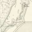
OS 6" map, (1957)
Dun Scalpsie, an Early Iron Age dun (information from F W Feachem, RCAHMS) is oval, measuring 97ft ENE-WSW, along its major axis. Though Hewison (1893) notes a 9ft wide wall on SE, there are now no remains of this, though tumbled rocks extend down the hillside for about 20ft. On the NW, at the entrance, the wall is 14ft 6ins thick, and what appears to be an inner wall 8ft thick and 1ft 6ins high runs parallel to it, 4ft away. This wall starts at a large mound of stones, 3ft high, 20ft x 4ft on the N, then runs W, joining the outer wall about 12ft beyond the entrance. It then continues for another 30ft before petering out. Hewison states that at the outer side of the wall, the doorway is 7ft wide, and 10ft wide on the inner. It is virtually obliterated by tumble and braken. He also notes 2 fosses on the SE slope, but no trace was found in 1959, though they could be obscured by tumble and bracken. A small section was cut in 1959. Artefacts found included a spindle whorl, comb fragment, whetstones, slag, animal teeth and bones. Two occupation levels were found, all the finds coming from the primary layer, except the bones, found in both layers.
J K Hewison 1893; R E MacCallum 1963.
Reference (1880)
Reference (1893)
Field Visit (27 May 1943)
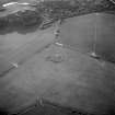
This site was recorded as part of the RCAHMS Emergency Survey, undertaken by Angus Graham and Vere Gordon Childe during World War 2. The project archive has been catalogued during 2013-2014 and the material, which includes notebooks, manuscripts, typescripts, plans and photographs, is now available online.
Information from RCAHMS (GF Geddes) 2 December 2014.
Excavation (July 1959)
Reference (31 August 1972)
Dun Scalpsie, an Early Iron Age dun (information from F W Feachem, RCAHMS) is oval, measuring 97ft ENE-WSW, along its major axis. Though Hewison (1893) notes a 9ft wide wall on SE, there are now no remains of this, though tumbled rocks extend down the hillside for about 20ft. On the NW, at the entrance, the wall is 14ft 6ins thick, and what appears to be an inner wall 8ft thick and 1ft 6ins high runs parallel to it, 4ft away. This wall starts at a large mound of stones, 3ft high, 20ft x 4ft on the N, then runs W, joining the outer wall about 12ft beyond the entrance. It then continues for another 30ft before petering out. Hewison states that at the outer side of the wall, the doorway is 7ft wide, and 10ft wide on the inner. It is virtually obliterated by tumble and braken. He also notes 2 fosses on the SE slope, but no trace was found in 1959, though they could be obscured by tumble and bracken. A small section was cut in 1959. Artefacts found included a spindle whorl, comb fragment, whetstones, slag, animal teeth and bones. Two occupation levels were found, all the finds coming from the primary layer, except the bones, found in both layers.
J K Hewison 1893; R E MacCallum 1963.
Field Visit (15 July 1975)
A dun, partly wrecked by the Local Defence Volunteers (LDV) in the Second World War. A trench was dug inside it not long ago when, according to Dorothy Marshall, a fragment of a bone comb was found.
Information from K A Steer [RCAHMS], 15 July 1975.
Field Visit (11 November 1976)
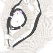
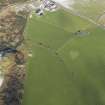
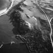
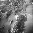
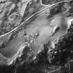
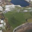
Dun Scalpsie is situated on a rocky knoll and measures overall 31.0m NNE-SSW) by 23.0m transversely. Its walling is best preserved on the W side where it is 4.3m thick with several large outer facing stones in situ. The inner face on this side is only recognisable near the entrance, the remainder of its course being overlain by a modern field wall. The entrance, very well defined and with no evidence of a door check, is 2.0m wide. All that remains of the wall on the S and E is a 2.5m wide band of stone with a considerable amount of tumbled material covering the slopes below. On the N side the wall has completely disappeared under a modern marker cairn and sheep shelter. There is a 2.0m wide spread of loose stones stretching from this cairn to a point 3.0m S of the entrance and although its purpose is not clear it is certainly not associated with the dun. There are no traces of the ditches mentioned by Hewison but a natural terrace 4.0m wide extends from the S around the E and N sides of the hill approximately 15.0m from the dun. The outer edge of this level terrace is traced by the slight remains of a wall, represented by a few outer facing stones and a scatter of stone. This wall 'encloses' a fairly large area of the steep E facing slope of the knoll but because its southern end merges with a modern field wall and the northern end is destroyed, its relationship to the dun cannot be ascertained. It is more likely however to be merely an old field wall rather than an outwork or annexe to the dun. The name Dun Scalpsie was confirmed locally.
Surveyed at 1:10 000.
Visited by OS (B S) 11 November 1976.
Field Visit (6 May 2009)
NS05NE 4 05480 58684
This dun, which is depicted on the 1st edition of the Ordnance Survey 6-inch map (Buteshire 1869, sheet CCXV), is largely as described by the Ordnance Survey. During the Second World War, the Local Defence Volunteers (LDV) built two machine-gun nests into its wall (on the N and S), and a stone shelter, built into the entrance on the W, may also date from this time.
Visited by RCAHMS (AGCH) 6 May 2009.
Publication Account (2009)
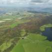
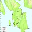
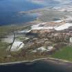
Dun Scalpsie is one of four duns on Bute and it forms part of the Scalpsie Bay archaeological landscape group. Dun Scalpsie sits on a prominent geological feature, occupying a commanding position over Scalpsie Bay and is comparable with the other dun sites recorded across Argyll in the RCAHMS Inventories. The surrounding landscape features include Thom’s Cut and its associated footbridges, World War II glider traps on Scalpsie beach, pre-Improvement and Improvement period farmsteads, an early medieval chapel site and two burial cairns.
This following excerpt from the RCAHMS database is a good example of a record in a revision project, where adding an additional text description may not be the most economic approach. For example, the OS and earlier descriptions were accurate on the date of visit, and contain details of the features of the dun. A more appropriate revision for this record could be to add further supporting text or images, not previously attached to the site. For example, the record revision project will add the text from the Ordnance Survey Name Book, which gives additional information about the antiquarian interpretation of such a site:
'A British fort situated on a tolerably commanding position on the farm of Scalpsie. The inner slope or wall is constructed of a mass of loose stones or boulders partly grown over with grass. The outer slope is chiefly natural partly assisted by art. Mr Gilp the farmer says it is handed down by tradition that a battle had been fought here between the Scotch and the Danes'.
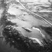
Another aspect of record revision would be to improve the illustrative material related to the site. The aerial photographs are black and white and there are no ground photographs. This site could be targeted during an aerial sortie to enhance the record with colour aerial photographs. A copy of the Emergency Survey site description has been scanned and will be added as an image to the record.
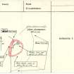
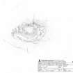
The record could also be enhanced by survey. The OS plan at 1:10,000 scale is relatively generalised and a site survey at a larger scale, would illustrate the detail of structural and topographic features.
Information from ‘The Royal Commission on the Ancient and Historical Monuments of Scotland, Commissioners’ Field Meeting 2009'.
Measured Survey (16 March 2010 - 17 March 2010)
RCAHMS surveyed Dun Scalpsie, Bute between 16-17 March 2010 with plane table and self-reducing alidade at a scale of 1:500. The plan was redrawn in vector graphics software for publication at a scale of 1:1000 (Geddes and Hale 2010, 26).
Note (9 July 2014 - 4 August 2016)
The fortification on Dun Scalpsie, a steep-sided hillock on the old shoreline on the NW side of Scalpsie Bay, comprises two elements: an inner enclosure on the summit; and an outer enclosure contouring round the hillock at a lower level. The enclosure on the summit is a roughly oval dun and measures about 24m from NE to SW by 18m transversely within a ruinous wall up to 4.3m in thickness where the faces are preserved on the S, but rather thinner in the entrance passage on the NW. The latter is relatively well-preserved, its sides still standing 1.2m high in the 1890s (Hewison 1893, 282), though only about 0.7m high in 1943. The outer enclosure is probably the remains of a fort, forming an irregular oval on plan, and tapering to a point where the wall runs up against an outcrop on the SSW. It measures about 70m from NNE to SSW by 35m transversely (0.18ha) within a wall reduced to little more than a terrace. Occasional stones of the inner and outer faces are visible, indicating an overall wall thickness on the E of about 3.5m, though the band of rubble elsewhere is much narrower, while on the W it merges with that of the dun on the summit; the entrance is also in this sector, coinciding with entrance into the dun and creating a faced passage 2m wide and 5m in overall length. The interior largely comprises the steep NE and SE flank of the hillock, but at the NNE end there are traces of a probable house platform about 8m in diameter. A small excavation carried out in 1959 (MacCallum 1959; 1963) on the S side of the interior of the dun revealed the inner face of the wall, built of large stones and pinnings and standing about 0.9m high, and possibly with evidence of a rougher later wall overlying it. A layer of clay butted against the basal course of the main wall, above which there were successive layers containing: domestic debris; sand of gravel; and tumbled stones from the wall mixed with more domestic debris. The finds from the layer above the clay included a fragment of bone comb, two whetstones, a spindle whorl and a fragment of slag.
Information from An Atlas of Hillforts of Great Britain and Ireland – 04 August 2016. Atlas of Hillforts SC1153

