Field Visit


Date 11 November 1976
Event ID 590067
Category Recording
Type Field Visit
Permalink http://canmore.org.uk/event/590067
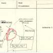
Dun Scalpsie is situated on a rocky knoll and measures overall 31.0m NNE-SSW) by 23.0m transversely. Its walling is best preserved on the W side where it is 4.3m thick with several large outer facing stones in situ. The inner face on this side is only recognisable near the entrance, the remainder of its course being overlain by a modern field wall. The entrance, very well defined and with no evidence of a door check, is 2.0m wide. All that remains of the wall on the S and E is a 2.5m wide band of stone with a considerable amount of tumbled material covering the slopes below. On the N side the wall has completely disappeared under a modern marker cairn and sheep shelter. There is a 2.0m wide spread of loose stones stretching from this cairn to a point 3.0m S of the entrance and although its purpose is not clear it is certainly not associated with the dun. There are no traces of the ditches mentioned by Hewison but a natural terrace 4.0m wide extends from the S around the E and N sides of the hill approximately 15.0m from the dun. The outer edge of this level terrace is traced by the slight remains of a wall, represented by a few outer facing stones and a scatter of stone. This wall 'encloses' a fairly large area of the steep E facing slope of the knoll but because its southern end merges with a modern field wall and the northern end is destroyed, its relationship to the dun cannot be ascertained. It is more likely however to be merely an old field wall rather than an outwork or annexe to the dun. The name Dun Scalpsie was confirmed locally.
Surveyed at 1:10 000.
Visited by OS (B S) 11 November 1976.