
Bute, Loch Quien South


Crannog (Period Unknown)
Site Name Bute, Loch Quien South
Classification Crannog (Period Unknown)
Canmore ID 40233
Site Number NS05NE 11
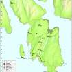
NGR NS 06190 59291
Datum OSGB36 - NGR
Permalink http://canmore.org.uk/site/40233


- Council Argyll And Bute
- Parish North Bute
- Former Region Strathclyde
- Former District Argyll And Bute
- Former County Buteshire
NS05NE 11 06190 59291.
See also NS05NE 12.
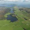
(NS 0619 5928) Lake Dwelling (NR) (site of).
OS 6" map, (1957)
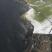
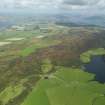
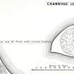
Hewison (1893-5) describes this crannog as pear-shaped, 90ft x 70ft with a heavy wall running round an inner area 50ft in diameter. In the centre of this he found a hearth but no artefacts. It was connected to the W shore of the loch by a 7ft broad causeway edged by a double row of oak posts and laid with small flagstones. In 1968, roughly the same features were found, though the water level was 2-3ft higher, and the surrounding wall is mostly under water. The causeway was not seen. probably due to depth of water and growth of reeds. When diving off the E side of the crannog, a Mr Knowles found 2 sets of piles in about 15ft of water lying 25-40ft out from the shelf. Probably this was some kind of jetty.
J Mackinlay 1862; J K Hewison 1893; D N Marshall 1969.
Reference (1862)
Reference (1893)
Reference (1969)
Desk Based Assessment (10 August 1972)
Hewison (1893-5) describes this crannog as pear-shaped, 90ft x 70ft with a heavy wall running round an inner area 50ft in diameter. In the centre of this he found a hearth but no artefacts. It was connected to the W shore of the loch by a 7ft broad causeway edged by a double row of oak posts and laid with small flagstones. In 1968, roughly the same features were found, though the water level was 2-3ft higher, and the surrounding wall is mostly under water. The causeway was not seen. probably due to depth of water and growth of reeds. When diving off the E side of the crannog, a Mr Knowles found 2 sets of piles in about 15ft of water lying 25-40ft out from the shelf. Probably this was some kind of jetty.
J Mackinlay 1862; J K Hewison 1893; D N Marshall 1969.
Field Visit (11 November 1976)
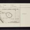
This crannog survives as a level vegetation-covered island 22.0m EW by 15.0m and 0.5m high. Although there is much stone to be seen the course of the wall can no longer be determined. There is also no trace of either the causeway or the piles noted by Knowles.
Surveyed at 1:10 000.
Visited by OS (B S) 11 November 1976.
Underwater Archaeology (2003)
NS 0618 5928 The crannog site at the SW corner of the loch was inspected below the water level and was found to consist of an artificial boulder mound, similar in construction to the site on the N shore; the entire mound appears to be artificial in origin. The site measures around 30m in diameter, while the dry area is c 18m in diameter. Nothing was seen of the heavy drystone wall previously reported (e.g. PSAS, 1861, 43-6), though a small length of rubble on the E edge of the dry area of the site may represent the remains of a ruinous wall. It is clear that the site has become heavily overgrown since the time of the inspections in the late 19th century, both in and above the water, and nothing is now visible of the possible walkway leading to the W shore noted at that time.
Sponsor: Dr J N Marshall (Isle of Bute) Memorial Trust.
M G Cavers 2003.
Field Visit (7 May 2009)
NS05NE 11 06190 59291
This crannog is as described by the previous authorities.
Visited by RCAHMS (AGCH) 7 May 2009.

