|
Manuscripts |
MS 1639 |
|
Report: A Survey of Crannogs on the Isle of Bute, Argyll and Bute Region, Scotland. |
10/2003 |
Item Level |
|
 |
On-line Digital Images |
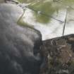
DP 062680 |
RCAHMS Aerial Photography Digital |
Oblique aerial view centred on the site of the crannog, taken from the N. |
6/2/2009 |
Item Level |
|
 |
On-line Digital Images |
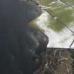
DP 062681 |
RCAHMS Aerial Photography Digital |
Oblique aerial view centred on the site of the crannog and enclosure, taken from the N. |
6/2/2009 |
Item Level |
|
 |
On-line Digital Images |
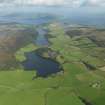
DP 066201 |
RCAHMS Aerial Photography Digital |
General oblique aerial view looking towards Rothesay from Scalpsie Bay, taken from the SSW. |
9/9/2009 |
Item Level |
|
 |
On-line Digital Images |
DP 066202 |
RCAHMS Aerial Photography Digital |
General oblique aerial view looking towards North Bute from Scalpsie Bay, taken from the S. |
9/9/2009 |
Item Level |
|
 |
On-line Digital Images |
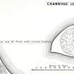
SC 1166652 |
Records of the Ordnance Survey, Southampton, Hampshire, England |
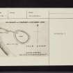
Plan, copied from OS '495' card |
11/11/1976 |
Item Level |
|
 |
On-line Digital Images |
SC 1166653 |
|
Plan by J Kay (Hewison 1893, 44). |
1893 |
Item Level |
|
|
Digital Files (Non-image) |
GV 004574 |
Records of the Royal Commission on the Ancient and Historical Monuments of Scotland (RCAHMS), Edinbu |
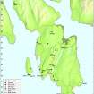
Map: Distribution of sites and artefacts of the Late Bronze Age and Iron Age. |
8/2010 |
Item Level |
|
 |
On-line Digital Images |
DP 097422 |
Records of the Royal Commission on the Ancient and Historical Monuments of Scotland (RCAHMS), Edinbu |
Map - Distribution of sites and artefacts of the Late Bronze Age and Iron Age. |
8/2010 |
Item Level |
|
 |
On-line Digital Images |
SC 2420117 |
Records of the Ordnance Survey, Southampton, Hampshire, England |
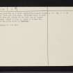
Bute, Loch Quien South, NS05NE 11, Ordnance Survey index card, page number 1, Recto |
1958 |
Item Level |
|
 |
On-line Digital Images |
SC 2420118 |
Records of the Ordnance Survey, Southampton, Hampshire, England |
Bute, Loch Quien South, NS05NE 11, Ordnance Survey index card, page number 1, Recto |
1958 |
Item Level |
|
 |
On-line Digital Images |
SC 2420119 |
Records of the Ordnance Survey, Southampton, Hampshire, England |
Bute, Loch Quien South, NS05NE 11, Ordnance Survey index card, page number 2, Verso |
1958 |
Item Level |
|
 |
On-line Digital Images |
SC 2420120 |
Records of the Ordnance Survey, Southampton, Hampshire, England |
Bute, Loch Quien South, NS05NE 11, Ordnance Survey index card, page number 2, Verso |
1958 |
Item Level |
|
|
All Other |
551 166/1/1 |
Records of the Ordnance Survey, Southampton, Hampshire, England |
Archaeological site card index ('495' cards) |
1947 |
Sub-Group Level |
|


