
Arran, North Glen Sannox


Corn Drying Kiln (Post Medieval), Field System (Post Medieval), Township (Post Medieval)
Site Name Arran, North Glen Sannox
Classification Corn Drying Kiln (Post Medieval), Field System (Post Medieval), Township (Post Medieval)
Canmore ID 40214
Site Number NS04NW 17
NGR NS 0013 4681
NGR Description Centred NS 002 468
Datum OSGB36 - NGR
Permalink http://canmore.org.uk/site/40214


- Council North Ayrshire
- Parish Kilbride
- Former Region Strathclyde
- Former District Cunninghame
- Former County Buteshire
NS04NW 17 centred 002 468
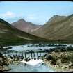
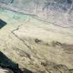
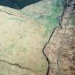
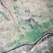
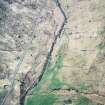
On the low ground near the North Sannox Burn are the remains of a small settlement cleared for sheep in 1829. The dry-stone walls of two houses are visible (probably byre-dwellings with cruck trusses) together with the corn- drying kiln, old field boundaries, clearance cairns, and with the head-dyke clearing showing above. This small settlement may well have originated as a shieling associated with a larger site near the present farmhouse, at NS 009 466.
Source: J N G Ritchie 1973.
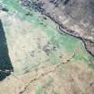
Two separate groups of ruined buildings. The W group, centred NS 001 468, comprises the ruins of four sub-divided rectangular buildings between 11.5m and 20.0m in length and 5.0m in average width. The walling is 0.8m wide and up to 2.0m high. There are also two other smaller much ruined buildings.
The E group, centred NS 004 468, is now overgrown with bracken, scrub and small trees. It comprises two main buildings also sub-divided and each measuring 18.5m by 5.5m with walling 0.8m thick and up to 1.5m high. There are also the remains of seven other, smaller, much ruined buildings.
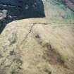
Field walls, clearance mounds and the head dyke are still clearly visible on the bracken-covered hillside, but the corn-drying kiln could not be located.
Visited by OS December 1977.
Note (22 December 1998)
A township, comprising two foci is depicted on the 1st edition of the OS 6-inch map (Buteshire {Island of Arran} 1869, sheet ccxxxviii).. The group to the W comprises six unroofed buildings and four enclosures and the group to the E comprises ten unroofed buildings and four enclosures. Thirteen unroofed buildings and five enclosures are shown on the current edition of the OS 1:10000 map (1980).
Information from RCAHMS (AKK) 22 December 1998.
Field Visit (19 March 2008 - 22 March 2008)
The western part of North Glen Sannox township was surveyed by volunteers attending a Scotland's Rural Past training course in March 2008. A field sketch, site description and photographs were prepared and added to the record.
Srp Note (29 July 2009)
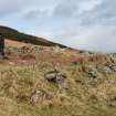
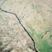
The western part of this settlement comprises eleven buildings extending NW /SE in linear formation for some 150m on a natural terrace above the North Sannox Burn. The settlement is situated at a height of approximately 40m above sea level on a south facing site below the rocky improved pasture of Torr Reamhar.
Six buildings are constructed of large rubble masonry with a wall thickness of up to 0.8m and standing up to 2.2m in height. These buildings are variously subdivided and extended and may have been occupied as byre dwellings. There are also five less well preserved buildings, some surviving as platforms only, and several enclosures which are defined by boulders and dry stone walling of smaller stones.
A corn drying kiln is situated at NR 003 468, some 200m to the east, on an eminence on the west bank of Allt na h-Ath. Rig and furrow extends across the improved pasture to the north and east of the settlement and there are lazy beds to the south.
Information from Scotland's Rural Past Arran Training Camp, March 2008.
Note (26 June 2018)
The location, classification and period of this site have been reviewed.
HES Survey and Recording 26 June 2018

