
Arran, Moss Farm


Chambered Cairn (Neolithic)
Site Name Arran, Moss Farm
Classification Chambered Cairn (Neolithic)
Alternative Name(s) Machrie Moor
Canmore ID 39707
Site Number NR93SW 12
NGR NR 9057 3237
Datum OSGB36 - NGR
Permalink http://canmore.org.uk/site/39707


- Council North Ayrshire
- Parish Kilmory
- Former Region Strathclyde
- Former District Cunninghame
- Former County Buteshire
Desk Based Assessment (20 February 1973)
NR93SW 12 9057 3237.
(NR 90583236) Cairn (NR)
OS 6" map, Buteshire (1924)
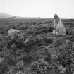
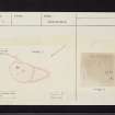
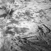
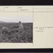
?Clyde group chambered cairn: This monument had already been almost completely destroyed by the middle of last century when it was recorded as a stone circle (J Bryce 1863). However, the stones appear to represent the last vestiges of a cairn with some large sandstone orthostats; probably the cairn was removed for metalling the nearby farm road.
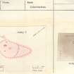
A little cairn material remains, but its edge is very indefinite, merging with the moorland. It certainly covers an area of 45ft E-W by 35ft N-S; Bryce gives its measurements as 82ft by 49ft. At the N edge one upright stone projecting 1ft 6 ins might have belonged to a peristalith.
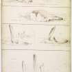
The most obvious feature is a stone set about 7ft within the E edge of the cairn. It faces ESE and is 3ft 3 ins wide by 6ft high. (A) Another slab 8ft to the S, facing E, is 3ft 4 ins long by 2ft 9 ins high. (B) These may be part of a facade. Behind the taller stone, at right angles to it, is a slab set on edge, projecting 2ft 9 ins, possibly the side stone of a chamber. (C) Around these stones are a number of displaced blocks and large rounded stones.
Sources: A S Henshall 1972, visited 1962; J Bryce 1863; J A Balfour 1910.
Field Visit (1976)
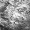
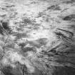
Two large orthostats visible suggesting a chamber of Clyde type. Information from DoE Arran field survey (1976), no. 36 (2).
Source: NMRS, MS/861/13.
Field Visit (16 September 1977)
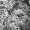
NR 9057 3237. The remains of a probable chambered cairn, as previously described are set on slightly raised ground on undulating moorland. It comprises a sub-oval spread of overgrown cairn material approximately 20.0m NE-SW by 16.0m NW-SE. An amorphous 'tail' of debris 1.2m high extends approximately 13.0 to SW and could form a further extent of the cairn. None of the four standing stones, as described, can be positively identified as part of a chamber, facade or kerb.
Surveyed at 1:10 000.
Visited by OS (J R L) 16 September 1977.
Note (23 July 2018 - 24 July 2018)
The location, classification and period of this site have been reviewed.
HES Survey and Recording 23-24 July 2018.

