
Pricing Change
New pricing for orders of material from this site will come into place shortly. Charges for supply of digital images, digitisation on demand, prints and licensing will be altered.
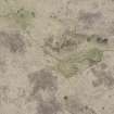
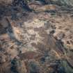
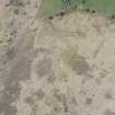
Arran, Machrie Moor 11


Plough Marks (Period Unassigned), Stone Circle (Neolithic) - (Bronze Age), Timber Circle (Neolithic)
Site Name Arran, Machrie Moor 11
Classification Plough Marks (Period Unassigned), Stone Circle (Neolithic) - (Bronze Age), Timber Circle (Neolithic)
Canmore ID 39704
Site Number NR93SW 1.05
NGR NR 91213 32426
Datum OSGB36 - NGR
Permalink http://canmore.org.uk/site/39704


First 100 images shown. See the Collections panel (below) for a link to all digital images.
- Council North Ayrshire
- Parish Kilmory
- Former Region Strathclyde
- Former District Cunninghame
- Former County Buteshire
NR93SW 1.05 91212 32416
E: at NR 9121 3242: A small 'circle' of two stones, 19ft (5.8m) in diameter.
Source: Name Book 1864
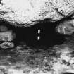
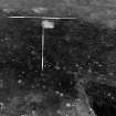
This circle is completely buried under peat; it was located by probing.
Source: E W MacKie 1975
This 'stone circle' is not visible but there are four small stones embedded in the peat at NR 9121 3241 (in the vicinity of the map reference given by Name Book). The largest of these stones is 0.8m high and the smallest 0.2m high. Their archaeological significance however is not obvious.
Surveyed at 1:10 000.
Visited by OS (BS) 13 September 1977
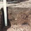
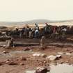
Excavation (1978 - 1979)
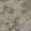
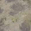
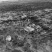
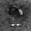
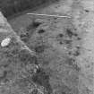
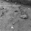
Excavations in 1978-9 have revealed under a covering of peat, 10 upright stones, and between each a pit (also 10 in number) possibly representing a post-hole, forming a stone circle measuring about 13.5m E-W x 12.5m N-S, with at least 6 buried stones forming no certain plan as yet, grouped within the circle in the NW quadrant.
Information from letter and plan from A Burl, Dept of Evolution and Prehistory, Hull College of Higher Education, 20 February 1980
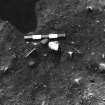
The tallest of the 10 stones is about 1.2m high and is set radially to the circumference on the W. They do not form any known plan of circle and it is suggested that the ring is the result of two semi-circles with centres 1.3m apart being joined together. The post holes contained fragments of charcoal, and disturbed packing stones in several of them suggested that the posts had been withdrawn perhaps when the stone circle(s) was constructed. Waste flakes, knives and scrapers of Arran pitchstone and diorite from the old land surface confirm the prehistoric age of this site. No sherds or human bone have yet been discovered.
A Burl 1980.
Excavation (April 1985 - June 1985)
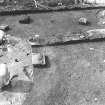
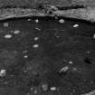
Excavations at two of the stone circles on Machrie Moor, both approximately 13m in diameter, continued work begun by Aubrey Burl in 1978 and 1979 (not previously reported in Discovery Excav Scot).
Site I, also dug into by James Bryce 1n 1861, consisted of eleven stones, alternately granite boulders and small sandstone slabs, surviving from a probable original' total of twelve. Of the six granite boulders, only one still stood erect; the others either leaned or had fallen over.
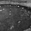
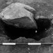
Site I had a complex stratigraphy duplicated in part by Site XI. At Site I after the stone circle had fallen into disuse and before peat covered the area, the ground was used as farm land evidenced by field clearance stone heaped against a fallen granite boulder and very slight remnants of field walls. At some time during the use of the stone circle, cremated bone was inserted at the base of one of the orthostats and the cremated remains apparently of a male aged 25-30 were placed In an off-centre pit, with a bone needle and burnt flint knife and covered by an inverted Cordoned Urn.
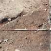
An approximate circle of stakeholes was found to surround the stones and may have preceded them but the relationship was tenuous. More definite was the fact that prior to the erection of the stone circle, a timber monument had stood in the same place. Postholes for its uprights were located beneath the stoneholes, where investigated, and one produced a Grooved Ware rim sherd.
Before this two intersecting lines of small stakes, not necessarily contemporary, had spanned the site and may indicate the use of hurdle fences for land division. Both of these stake lines cut a dense series of ardmarks generally aligned NE SW but with occasional more widely spaced ardmarks at right angles to them. Further stake lines were located under this horizon.
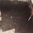
In the centre of the site two phases of pits had been dug, some of which were stone filled. They formed an approximate circle of 6m diameter. Investigation of these will continue in 1986.
Site XI (continuing Burl's numbering) largely hidden under the peat until 1978, comprised ten stones, all but one of sandstone, and was complete although one stone had fallen since Burl's excavation.
At Site XI there was no evidence for field clearance after the abandonment of the circle. No sequence of timber phase to stone phase for the monument could be proved, as the ten postholes were spaced between the standing stones with no direct stratigraphical relationship.
During the use of the circle an approximately central pit was dug which contained the cremated remains apparently of a male aged about 30 and a flint core.
Similar pre-circle land division and agricultural phases to those of Site
I were noted, as were various earlier pits which were not fully investigated.
Many finds of pitchstone, flint and pottery came from both sites.
Sponsor: HB&M
Excavation (April 1986 - June 1986)
The final season of work at stone circles Sites I and XI involved extending the area under excavation to incorporate the two former trenches (Discovery Excav Scot 1985, 41-2).
At Site I postholes representing the complete circuit of the former timber circle directly underlying the stone circle were located, as was a further concentric ring of postholes outwith the stone circle. The central features thought to be two phases of pits resolved themselves into a c 6m diameter ring of large postholes with scoops, presumably to facilitate the erection of the timber uprights. Within Site I a further posthole ring was found which was not concentric with the other three.
Several new lines of stakeholes which possibly indicate the use of hurdle fences were found.
Many more finds of pitchstone and flint were made and some pit features produced large amounts of pottery.
Sponsor: SDD - HBM
Note (23 July 2018 - 24 July 2018)
The location, classification and period of this site have been reviewed.
HES Survey and Recording 23-24 July 2018.

