
Following the launch of trove.scot in February 2025 we are now planning the retiral of some of our webservices. Canmore will be switched off on 24th June 2025. Information about the closure can be found on the HES website: Retiral of HES web services | Historic Environment Scotland
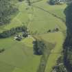
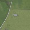
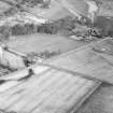
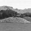
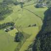
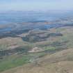
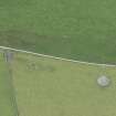
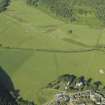
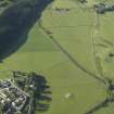
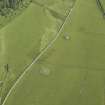
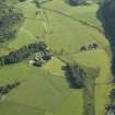
Nether Largie North


Cairn (Bronze Age)
Site Name Nether Largie North
Classification Cairn (Bronze Age)
Canmore ID 39482
Site Number NR89NW 4
NGR NR 83090 98470
Datum OSGB36 - NGR
Permalink http://canmore.org.uk/site/39482


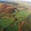
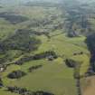


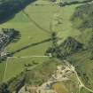

- Council Argyll And Bute
- Parish Kilmartin
- Former Region Strathclyde
- Former District Argyll And Bute
- Former County Argyll
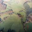
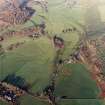
NR89NW 4 8309 9847.
(NR 8309 9847) Cairn (NR)
OS 6" map, Argyllshire, 2nd ed., (1900)
The New Statistical Account notes 'urns' found in cairns in the Kilmartin Valley.
NSA 1845
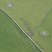
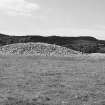
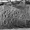
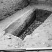
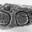
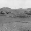
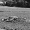
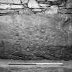
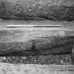
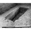
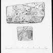
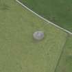
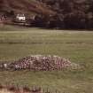
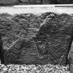
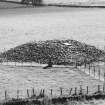
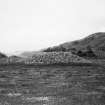
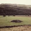
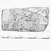
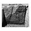
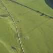
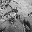
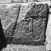
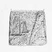
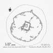
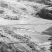
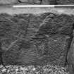
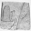
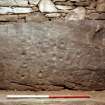
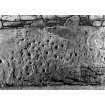
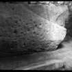
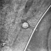
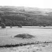
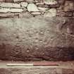
The North Cairn, Nether Largie, was excavated by Craw in 1930. The cairn, which measured 71' x 67' x 8'9", covered a platform 46' x 44' enclosed by a bank 8' wide x 2' high externally, 1' above the platform, with an interval at the SE. The central cist, 5'2" x 2'5" x 1'10" contained ochre, charcoal, and a molar, with dark soil. There was also an oval grave containing dark soil, charcoal and an ox tooth. An upright stone under the cairn, now hidden, had two incised ovals on its W face. The N end-slab of the cist was sculptured with two flat axes, while the cover stone, a massive slab, 6'7" x 3'5" x 9" bore cup marks and axe carving. The stones removed by the excavators were built into a protective wall round the cairn.
J H Craw 1930; M Campbell and M Sandeman 1964
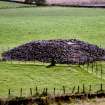
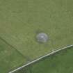
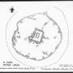
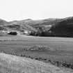
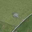
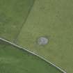
Generally as described. The cairn is enclosed by a railed fence and measures 20.0m in diameter. The cover stone of the cist bears 41 cup marks.
Resurveyed at 1:2500.
Visited by OS (IA) 26 April 1973
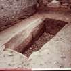
Nether Largie - North Cairn (DoE nameplate) is 2.6m high and is generally as described. A concrete inspection chamber has been built around the central cist, and the cairn has been rebuilt around this. Surveyed at 1/2500.
Visited by OS (TRG) 15 February 1977
Field Visit (May 1982)
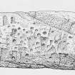
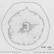
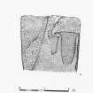
This cairn measured 21.6m from N to S by 20m transversely and 2.7m in height; there were no kerbstones, but Craw states that the central area of the cairn (14m by 13.4m) was enclosed within a bank of stones some 2.4 m thick and standing 0.6m high externally and 0.3m internally. A little to the N of the centre there was a massive cist aligned N and S and set into a pit dug into the natural gravel, with the top of the cover slab about 150mm below ground level. The underside of the capstone, which measures 2m by 1.07m and up to 0.35m in thickness, is decorated with about forty cupmarks and at least ten axeheads. The cist had been additionally protected by eighteen flat slabs which lay on top of the capstone, two overlapping the edge of the cover stone at the ends of the cist and the others arranged along the edges and across the top. The cist, which measures 1.6m by 0.65m and 0.6m in depth, contained soil, in which were found a human molar tooth, a little ochre, and a few fragments of charcoal. The inner face of the N end-slab was decorated with two large axeheads, their edges to the top. To the S of the central cist an arrangement of slabs suggested that there might have been a further burial, but none was found; at either end of the setting, however, there were two upright slabs, one of which, at the E end, was decorated with two pecked circles each about 180mm in diameter. This slab is now in the Royal Museum of Scotland, Edinburgh. A second grave was found 3.3m NE of the central cist; here an oval pit dug into the natural gravel measured 1.5m by 0.7m and 0.8m in depth and contained an ox molar and fragments of charcoal.
RCAHMS 1988, visited May 1982.
Measured Survey (May 1982)
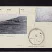
RCAHMS surveyed Nether Largie North cairn on May 1982 with plane-table and alidade producing a plan at a scale of 1:100. The plan of the cairn was redrawn in ink and published at a scale of 1:250 (RCAHMS 1988a, 68).

