
Pricing Change
New pricing for orders of material from this site will come into place shortly. Charges for supply of digital images, digitisation on demand, prints and licensing will be altered.
Nether Largie


Standing Stone(S) (Prehistoric)
Site Name Nether Largie
Classification Standing Stone(S) (Prehistoric)
Canmore ID 39471
Site Number NR89NW 3
NGR NR 8282 9760
Datum OSGB36 - NGR
Permalink http://canmore.org.uk/site/39471


First 100 images shown. See the Collections panel (below) for a link to all digital images.
- Council Argyll And Bute
- Parish Kilmartin
- Former Region Strathclyde
- Former District Argyll And Bute
- Former County Argyll
NR89NW 3 8282 9760.
(Centered NR 8282 9760) Standing Stones (NR) (5 shown)
OS 6" map, Argyllshire, 1st ed., (1874)
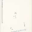
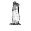
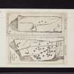
A group of five standing stones, positions and dimensions as shown on plan. The single central stone has four small stones forming a rectangle round its base. This central stone, (A), bears cup, and cup-and-ring marks as illustrated, and stone 'B' on plan bears 3 cup marks, also illustrated.
J R Allen 1882; J H Craw 1930; M Campbell and M Sandeman 1964.
Generally as described. Stone 'A' bears up to 23 cup marks, 3 of which show faint indications of rings.
Resurveyed at 1:2500.
Visited by OS (I A) 26 April 1973.
As described in the previous information.
Surveyed at 1/2500.
Visited by OS (T R G) 15 February 1977.
Field Visit (November 1983)
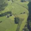
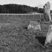
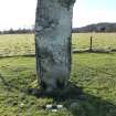
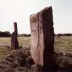
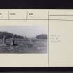
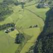
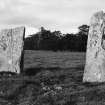
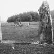
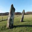
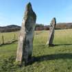
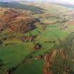
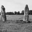
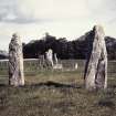
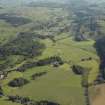
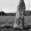
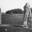
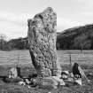
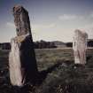
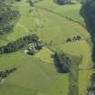
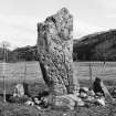
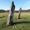
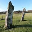
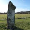
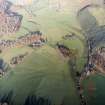
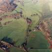
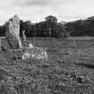
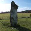
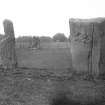
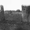
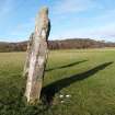
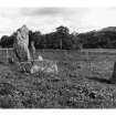
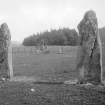
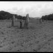
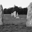
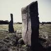
Situated in fields on the W side of the Kilmartin Burn and about 250m SE of the Temple Wood stone circles (NR89NW 6), there is a complex setting of standing stones aligned approximately NE and SW. At each end of the alignment there is a pair of upright stones with two intermediate settings of four stones and five stones respectively; 100m to the NW of the N end of the alignment there is a single outlying stone. In 1973 excavation revealed the stump of a further stone some 300m W of the S end of the alignment, but it has since been covered up again.
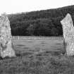
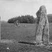
The southernmost pair of stones (A, B) is aligned roughly NNW-SSE, and the long axis of each stone has the same alignment.
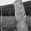
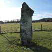
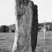
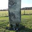
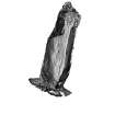
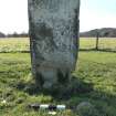
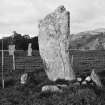
A. This stone is 2.75m high and 0.8m by 0.5m at the base, and tapers to a pointed top.
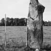
B. Standing to a height of 2.8m and measuring 0.8m by 0.37m at the base, this stone has straight sides and a top which falls from NW to SE. On the NE face there are three cupmarks; the largest is 70mm in diameter and 15mm deep, and the other two are 60mm and 50mm in diameter and 15mm deep.
The four-stone group is situated some 24m to the NNE of A and B. Stones C and E stand 4.4m apart, the long axes of each lying parallel with the main alignment of the entire setting, but that of D approximates to that of A and B.
C. This stone is 0.92m high and 1.05m by 0.2m at the base. It has straight sides and a broken top.
D. An upright slab 0.75m high and 1.3m by 0.15m at the base; it has straight, slightly tapering sides and a flat top.
E. A further slab 0.4m high and 0.68m by 0.2m at the base, it has straight sides and a broken top.
A further stone, now fallen, appears to complete the SW side of this setting; just protruding through the turf, it measures 0.53m in length, but its thickness is uncertain (Campbell and Sandeman 1964).
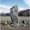
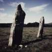
Situated some 6.5m to the NNE, the five-stone group comprised a large central upright (F) and two pairs of flankers (G, I; J, H), only three of which remain in position. There is some field clearance round about, but there is no evidence that it represents a denuded cairn.
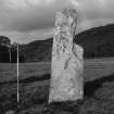
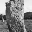
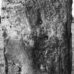
F. This stone is 2.8m high and 0.95m by 0.2m at the base; it rises with slightly bowed sides to an irregularly pointed top. On its SW face there are about forty cupmarks, one complete cup-and-ring marking, and two cups with gapped circles, in one case with a radial groove (Campbell and Sandeman 1964).
G. This stone now slopes slightly inwards towards stone F and measures 0.83m in height and 0.9m by 0.3m at the base.
H. This small upright stone is 0.3m high and 0.9m by 0.2m at the base.
I. This upright stone is 0.6m high and 0.7m by 0.15m at the base.
J. A fallen slab which measures 1m by 0.6m and about 0.2m in thickness.
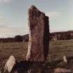
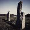
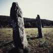
The northernmost pair (K, L) lies 34m further to the NNE, in disposition and alignment corresponding very closely to southernmost pair (A, B).
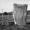
K. This stone (2.85m high and 0.96m by 0.38m at the base) has straight sides, which rise to what would have been a rounded top with a slight point, but a piece of the SE side has been broken off.
L. This rectangular block is 2.7m high and 1.1m by 0.4m at the base; its sides slope slightly outwards and it rises to a flat top. There are three cupmarks on the SW face at a height of about 1.5m, measuring between 40mm and 50mm in diameter and up to 15mm in depth. A fourth marking may either be another cupmark or perhaps a natural depression (Hoek and Kahane 1982).
M. Situated 100m to the NW, aligned NE-SE and now leaning to the SE, this stone was formerly about 1.8m high; it has straight sides and a top slanting from SE to NW; it measures 0.55m by up to 0.3m at the base.
N. The stump of a standing stone was discovered in 1973 at a point about 300m to the W of the main alignment and 260m SSW of Temple Wood. Aligned NW and SE, it was 0.82m long and appears to have been a thin slab broken just below present ground level.
Visited November 1983
RCAHMS 1988
Measured Survey (November 1983)
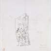
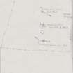
RCAHMS surveyed Nether Largie standing stones on November 1983 with plane-table and alidade producing a plan at a scale of 1:100. The plan of the standing stones was redrawn in ink and published at a scale of 1:250 (RCAHMS 1988a, 136).
Geophysical Survey (1993)
A geophysical survey was made by GUARD in 1993 at Nether Largie, 12 grids, each 20m by 20m being surveyed. A large number of potentially interesting anomolies were detected, but only excavation can confirm their interpretation.
With reference to the location plan of Nether Largie Standing Stones (RCAHMS 1988, 136), Stones C,D and E with a stump on the SW forming a Four-Post Arrangement.
While surveying this area the probes of the RM4 frame came into contact with a large stone immediately below the surface; the corner of which protruded above the surface. A very thin layer of turf was easily peeled back to reveal a possibly fallen standing stone measuring 820mm by 230mm lying in a NE to SW orientation and closest to the stump, so possibly its upper body. After recording the turf was rolled back to its original position.
Sponsor: Historic Scotland
D Abernethy 1993
Excavation (March 2013 - April 2013)
NR 8282 9760 An outlying stone of The Nether Largie Standing Stone group collapsed in the autumn of 2012. A programme of work was undertaken, March–April 2013, to investigate the stone pit and reinstate the stone. The excavation recorded an oval pit, which had been packed with stones around the base of the stone on the E side. The lack of packing on the S side of the pit may have allowed the stone to lean and ultimately fall in this direction. Apart from the packing stones, no artefacts were recovered from the original fill of the pit. The stone was reinstated on 17 May 2013. Two groups of previously unnoticed cup marks were noted on the original W side of the stone. A group of three at its base and three eroded cups on its upper face.
Archive: Kilmartin Museum. Report: OASIS, RCAHMS and WoSAS
Funder: The Craigend Trust and Historic Scotland
Roddy Regan, Kilmartin Museum, 2013
(Source: DES)
Note
Date fieldwork started: 01/08/2018 & 13/11/2019
Compiled by: Kilmartin
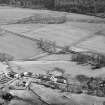
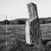
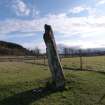
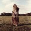
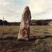
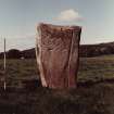
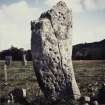
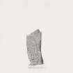
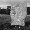
Location notes: Positioned at the lowest point of Kilmartin Glen in flat fields approximately 80m to the NW of the Kilmartin burn and 250m to the SE of Temple Wood stone circles (Canmore 39504, 39517) is a monument comprising multiple standing stones (Canmore ID: 39471). The linear monument runs SW to NE and can be found in a field on the W side of the B8025 road just before it meets the A816 to the NE of the site. 500m to the SW is Ri Cruin cairn (Canmore 39456); 250m to the WNW are the stone circles at Temple Wood (Canmore 39504) and 300m to the N is Nether Largie South chambered cairn (Canmore 39460). A public footpath path runs from a small foot bridge across the Kilmartin burn in the east, through the middle of the linear monument directly passing the central standing stone, before continuing west towards the Temple Wood stone circles (Canmore 39504). At the time of survey the field was in use for sheep grazing and the vegetation was low around the monument. Three of the standing stones in the Nether Largie alignment have been decorated with cup and cup and ring motifs, including the central stone, the NW stone and standing stone 3. Standing Stone 3 is the southern-most of the stones in this monument.
Panel notes: Standing stone 3 is a tall, roughly rectangular schist stone with a wider top section and pointed tip, measuring about 2.8m in height and a maximum of 1.1m in width at its thickest part. The stone is vertical but has shifted to lean slightly towards the N. The N face of the stone has been carved with a line of 3 possible cupmarks, one of which is more oval than circular.
Note
Date fieldwork started: 13/11/2019
Compiled by: ScRAP
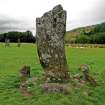
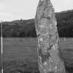
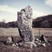
Location notes: The standing stone is situated in improved pasture in a flat valley running NE/SW within an area of prehistoric monuments. It is the south-easterly most stone in a group of five standing stones (Canmore ID 39471). Three of these standing stones have motifs on them; In addition to this stone, the central standing stone (ScRAP 3106) has cup and ring carvings on its SW facing surface, the most north westerly stone (ScRAP 3301) has 3 cupmarks on its SW face. Nether Largie South Cairn can be seen approximately 150m NW. There is an outlying standing stone is approximately 50m to the W, and the stone circle of Temple Wood is about 150m to the W. The panel is reached from the Lady Glassary car park approximately 50m to the E, which is off the A816, about 1 mile S of Kilmartin Village.
Panel notes: Roughly rectangular schist standing stone tapered at the top. Its maximum height is 2.8m and width is 0.9m, with a thickness of 0.4m. The stone leans slightly to the N. There are 3 large cupmarks in a rough alignment in the central area of the stone's NE face.

