Accessibility

Font Size

100% 150% 200%

Background Colour

Default Contrast
Close Reset

Arran, Tormore

Cairnfield (Prehistoric), Hut Circle (Prehistoric)

Site Name Arran, Tormore

Classification Cairnfield (Prehistoric), Hut Circle (Prehistoric)

Canmore ID 39230

Site Number NR83SE 11

NGR NR 8914 3075

Datum OSGB36 - NGR

Permalink http://canmore.org.uk/site/39230

Ordnance Survey licence number AC0000807262. All rights reserved.
Canmore Disclaimer. © Bluesky International Limited 2025. Public Sector Viewing Terms

Toggle Aerial | View on large map

Digital Images

Tormore, oblique aerial view, taken from the WSW, centred on a hut-circle. A further hut-circle is visible in the centre right of the photograph.
Tormore, oblique aerial view, taken from the WSW, centred on a hut-circle. A further hut-circle is visible in the centre right of the photograph.Oblique aerial view.Arran, Tormore, NR83SE 11, Ordnance Survey index card, page number 1, RectoOblique aerial view.Oblique aerial view.Oblique aerial view.Tormore, oblique aerial view, taken from the W, centred on a hut-circle. A further hut-circle is visible in the centre right of the photograph.Tormore, oblique aerial view, taken from the SSW, centred on two hut-circles. Further hut-circles are visible in the bottom right-hand corner of the photograph.Oblique aerial view.Oblique aerial view.Tormore, oblique aerial view, taken from the NW, centred on a hut-circle. Further hut-circles are visible in the top centre and bottom left-hand corner of the photograph.Tormore, oblique aerial view, taken from the SW, centred on a hut-circle. A further hut-circle is visible in the centre left of the photograph.

Administrative Areas

  • Council North Ayrshire
  • Parish Kilmory
  • Former Region Strathclyde
  • Former District Cunninghame
  • Former County Buteshire

Archaeology Notes (1973 - 1977)

NR83SE 11 8914 3075.

(NR 8914 3073) Hut Circle (NR)

OS 6" map, (1924).

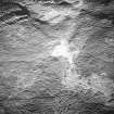
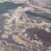
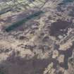
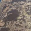
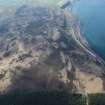
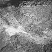
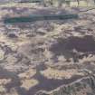
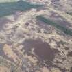
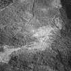
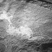
NR 8914 3075. A heather-covered hut circle is situated in undulating moorland at approximately 350ft OD. The earth and stone bank, spread to 3.5m and up to 1.0m high, encloses a level, featureless interior 7.0m in diameter. The entrance is not clear, but a slight lowering of the bank in the south-west may indicate its position.

To the north and west of the hut is a group of heather-covered stony mounds. They average 4.0m in diameter and 0.5m in height. These are clearance heaps contemporaneous with the hut, but there is no evidence of a field pattern.

Surveyed at 1:10,000.

Visited by OS (TRG) 13 October 1977.

Activities

Note (27 November 2018)

The location, classification and period of this site have been reviewed.

HES Survey and Recording 27 November 2018

References

MyCanmore Image Contributions


Contribute an Image

MyCanmore Text Contributions