
Following the launch of trove.scot in February 2025 we are now planning the retiral of some of our webservices. Canmore will be switched off on 24th June 2025. Information about the closure can be found on the HES website: Retiral of HES web services | Historic Environment Scotland
Macharioch Farm, Motte


Motte (Medieval)
Site Name Macharioch Farm, Motte
Classification Motte (Medieval)
Canmore ID 38691
Site Number NR70NW 3
NGR NR 72713 09417
Datum OSGB36 - NGR
Permalink http://canmore.org.uk/site/38691


- Council Argyll And Bute
- Parish Southend
- Former Region Strathclyde
- Former District Argyll And Bute
- Former County Argyll
NR70NW 3 72713 09417
Motte [NAT]
OS (GIS) MasterMap, August 2010.
Location formerly entered as NR 7271 0941.
NR 7271 0942. The motte is as described and planned by RCAHMS.
Surveyed at 1:2500.
Visited by OS (JB), 3 October 1977.
Field Visit (28 July 1955)
Visited by RCAHMS (KAS) 28 July 1955.
Notebook p32.
Reference (1957)
This site is noted in the ‘List of monuments discovered during the survey of marginal land (1951-5)’ (RCAHMS 1957, xiv-xviii).
Information from RCAHMS (GFG), 24 October 2012.
Field Visit (August 1965)
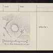
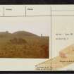
NR 726 094. An earthwork, presumably a motte, is situated about 800m W of Macharioch Farm; it comprises a small natural mound, shaped like a truncated cone, which is partially enclosed by a ditch and outer bank. The flat-topped summit and sloping sides of the mound appear to have been artificially trimmed, and the ditch and bank have likewise been formed by the adaptation of existing features of natural origin. The ditch and bank appear formerly to have protected the mound on all sides except the N, where the steep natural fall of the ground makes such a provision unnecessary. At a point on its SE sector the ditch is interrupted by an entrance causeway 1.2m in width. The summit of the mound has a diameter of approximately 7.5m and an average height above the existing level of the ditch bottom of 2.1m. The ditch itself is flat-bottomed and about 1.8m in width. Nothing is known about the history of this earthwork.
RCAHMS 1971, visited August 1965.
Field Visit (3 October 1977)
NR 7271 0942. The motte is as described and planned by RCAHMS.
Surveyed at 1:2500.
Visited by OS (JB), 3 October 1977.

