
Islay, Mulreesh, Lead Mines


Engine House (Post Medieval), Lead Mine(S) (Post Medieval), Rig And Furrow (Medieval) - (Post Medieval)
Site Name Islay, Mulreesh, Lead Mines
Classification Engine House (Post Medieval), Lead Mine(S) (Post Medieval), Rig And Furrow (Medieval) - (Post Medieval)
Canmore ID 38126
Site Number NR46NW 7
NGR NR 40138 68547
NGR Description centred on building south of former engine house
Datum OSGB36 - NGR
Permalink http://canmore.org.uk/site/38126


- Council Argyll And Bute
- Parish Killarow And Kilmeny
- Former Region Strathclyde
- Former District Argyll And Bute
- Former County Argyll
NR46NW 7.00 4016 6875.
NR46NW 7.01 4014 6827 Islay, Mulreesh Reservoir
NR46NW 7.02 4019 6823 Islay, Mulreesh, Lead Mines, Office
For general account of lead mining on Islay (with mention of production at Mulreesh), see NR36NE 21.
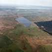
(NR 4002 6896; NR 4006 6904; NR 4010 6903; NR 4017 6874; NR 4023 6861) The old lead mines at Mulreesh have been worked from Norse times, but most actively in the 18th century. The most impressive remaining feature is a rubble engine house, now roofless, with a short range of cottages adjoining. Nearby is a concrete-lined rubble dam which supplied water to a group of bouldings, now ruinous.
J R Hume 1977.
The old lead mine-workings extend over an area some 700m, N-S, by 200m centred on NR 401 688. The openings to about ten shaft and drift mines are visible. The engine house is at NR 4018 6873; the dam, outside the general field of activity, is at NR 4015 6825.
Visited by OS (J M) 3 April 1979.
The most extensive remains of lead mines on Islay are at Mulreesh where there are abandoned shafts, waste-dumps and an adit, together with the ruins of a rubble-built engine house and an ore-dressing plant, all belonging to the latest phases of mining activity in the second half of the 19th century. Much of the limestone was evidently ore-bearing at the surface and, according to Dr John Walker, this was the first recorded discovery of metallic veins in limestone in Scotland. [See NR36NE 21 for a general description of lead mining on Islay] Earlier mining operations are indicated by a surrounding field of open-cast workings, the ubiquitous 'trenching ... not above six feet deep' observed by Pennant in 1772 and the 'innumerable shallow pits and trenches' criticised by another visitor to the mines sometime before 1810.
Visited by RCAHMS May 1967
T Pennant 1774; J Williams 1810; RCAHMS 1984a
Mulreesh was the principal works of the Islay Lead Mining company and represents the largest lead works in the study area and the last to be worked. A NW trending vein of calcite and dolomite with galena, sphallerite, pyrite and chalcopyrite was worked in the 18th and 19th centuries.
The Mulreesh earthworks are set in a valley bottom currently used as rough grazing. Four dwellings and a series of shafts have been identified lying on the 80m contour in an area to the S of the later 19th century workings. three adjoining rubbish-filled shafts are flanked by a track way that leads to a hollow way running between buildings A, B, C and D. Within this knoll, a water-filled adit drains southwards to eventually join a nearby burn. At the time of the survey, the adit contained water to the depth of about 1m and was free-flowing. The N bank of the adit overlies the boundary of building B, suggesting that the adit is later than the close. This assumption is supported by the fact that a box-drain in the centre of the metalled track is ocverlain by the adit bank.
Building A incorporates large blocks of roughly dressed Dalradian limestone, most probably quarried from the nearby workings. A large stone at the base of the southern end of building A has a sectioned shot hole (30mm in diameter). This shows that this building is either contemporary or later than the nearby workings. Building C has a rectangular enclosure with very pronounced upstanding earth banks. Building D adjoins parallel banks that flank a small track that runs westwards. To the S of this track an area of broad and narrow rig and furrow survives along with a small trial pit and a shaft.
M Cressey 1993.
This survey was undertaken in April 1994 as a follow-up study to previous work (supra).
The 1993 (Phase 1) survey identified a small settlement whose origins lie within the first phase of mining at the site.
60m W of this region lie the ruins of a possible smithy or small workshop. N of the phase 1 earthworks is the rubble-built engine house that has been incorporated onto the gable end of a single-storey building. This building was last occupied as recently as the early 1970s. N of this building are the ruins of two cottages that were associated with the mine. NW of the engine house is a large tract of flat featureless land with only the remains of fenced-off mine shafts. The shafts close to the engine house are lined with dressed stone. The others are fenced off and too dangerous to investigate.
The North Shaft is now flooded completely but the remains of what appears to be winding gear and timbers survive. This region contains the largest tailings dumps in the area. Some of the tailings dumps are grassed over, but where they are exposed, an assortment of large irregular-shaped rocks of limestone and quartz can be seen. Immediately N of the North Shaft, a large open cast runs close to a drystone boundary wall that incorporates waste rock from the mine. Cut into the escarpment is an adit with a rubbish-filled entrance. Two large banks approximately 1.5m high lead away from the adit to an area littered with mine tailings.
S of the North Shaft, a large ovoid feature could be a catch basin for holding water and may have originally been supplied by a series of wooden troughs from the North Shaft.
The remains of the Mulreesh mine are more extensive than previously thought. Only a fragment remains of what must have been an intensive operation, particularly in the mid-18th century when steam power was used to drain the mine. Two phases of mining can be established.
Acknowledgements: The writer wishes to acknowledge Mr D Boyed, Factor of the Islay Estates for allowing access to land and historical data. Roger McWee is thanked for his assistance in the field. The Society of Antiquaries of Scotland is thanked for their financial support.
Sponsor: Society of Antiquaries of Scotland.
M Cressey 1994.
NR 402 685 Twelve pits were opened in connection with the refurbishment of overhead power lines across the remains of the mine complex (Cressey 1993). They produced limited evidence of archaeological remains: trackway make-up matrix; the upcast from the westernmost shaft; and garden soils related to nearby cottages.
Sponsor: Scottish Hydro-Electric plc.
K Speller 1997
Field Visit (May 1976)
Traces of former lead-workings on Islay are distributed over a wide area which extends from Balulive in the N to Loch Bharradail in the S, and they are associated with groups of Dalradian limestone. The most extensive remains of lead mines on Islay are at Mulreesh (NR4068), where there are abandoned shafts, waste-dumps and an adit, together with the ruins of a rubble-built engine house and an ore-dressing plant, all belonging to the latest phases of mining activity in the second half of the 19th century. Much of the limestone was evidently ore-bearing at the surface and, according to Dr John Walker, this was the first recorded discovery of metallic veins in limestone in Scotland (en.1). Earlier mining operations are indicated by a surrounding field of open-cast workings, the ubiquitous ‘trenching ... not above six feet deep' observed by Pennant in 1772 and the 'innumerable shallow pits and trenches' criticised by another visitor to the mines some time before 1810 (en2).
The remains of similar open-cast operations and later shafts can be seen at the former mines of North and South Ardachy which cover much of the area E and SE of Loch Bharradail (NR3963), and which together formed one of the main centres of the island's lead-mining industry in the 18th century. Another principal vein that was worked in similar fashion is situated at Gartness (NR3965- 6) SE of Ballygrant village, while lead-mining at Kilslevan (NR4167) succeeded the working of copper ore which had commenced there about 1760. There are no identifiable remains of the lead smelting furnace that was in operation at the date of Pennant's visit in 1772 (en3); it was situated 'near Freeport', an unidentified site near Port Askaig, probably at, or close to the site of the later distillery at Caol Ila (NR428700).
Many of the old workings may be of medieval origin, and in 1549 Donald Monro referred to the occurrence of 'mekle leid ovir (much lead ore) in Moychaolis' (en.4). An abortive attempt was made to realise some of the value of the lead deposits in 1619, and from about 1680 onwards the workings were intermittently exploited by a succession of lessees, most notably during the third quarter of the 18th century and again after 1862 (en.5). Mining operations ceased in about 1880 and much of the plant and machinery was sold after the termination of the final lease in 1904.
Detailed reports compiled in 1770 gave a comparatively favourable account of the physical condition and potential capacity of the mines, the expense of working them and the quality of the lead itself which was said to have much impressed Alexander Sherriff, manager of the Leadhills mines (en.6). The reports provide some indication of the amount and value of the lead extracted, but the only available annual set of figures on output relate to the last active phase at Mulreesh (NR46NW 7) between 1862 and 1880; during that nineteen-year period a total of 1,919 tons of ore produced 1,426 tons of lead and 18,424 ounces of silver (en.7).
There are few reliable details concerning the size and composition of the work-force. It is known, however, that John Taylor, a celebrated centenarian (en.8), was employed as overseer of a large body of English miners on Islay during the earlier part of his career from 1708 to 1730, and a rental of 1722 records that the dwellings of the miners 'in the mynes of Isla' were at that date situated at Knocklearoch (en.9) where building-foundations of indeterminate date and character are still to be found in the vicinity of the more modern farmstead (NR399649).
RCAHMS 1984, visited May 1976
Endnotes
1.McKay, M M (ed.), The Rev Dr John Walker's Report on the Hebrides of 1764 and 1771 (1980), 106.
2.Pennant, Tour (1772) , 1, 250; Williams, J, The Natural History of the Mineral Kingdom (2nd ed., 1810), 1, 276.
3.Pennant, loc. cit. See also British Library, Add. MS 15,509, fol. 5.
4.Monro, Western Isles, 55. For 'Moychaolis', see Inventory of Argyll, 4, 274, n.200.
5.Islay Bk. , 365- 7, 456-7; Islay Estate Papers, Mining Papers (uncatalogued). See also Nat. Lib. of Scot., Murray of Stanhope Papers, Adv. MS 29.1. 1, vol. 7, fol. 38, for reference in a document of 1722 to a contract between Dame Elizabeth Campbell of Calder and John Pollock of Dublin for mineral rights, 9 January 1707. Summaries of the historical and geological background are contained in Wilson, G V and Flett, J S, The Lead, Zinc, Copper and Nickel Ores of Scotland (Special Reports on the Mineral Resources of Great Britain, 17, 1921),65- 73; and Barnett, G W T, 'Lead in Islay', in The Future of Non-Ferrous Mining in Great Britain and Ireland (Institution of Mining and Metallurgy, 1959), 65-76.
6.Islay Bk. , 458-67, espec. 465; a copy of a 1770 report on the Islay mines is also contained in Edinburgh University Library, MS D.c. 1.57, ff. 96-9.
7.Ibid., and 467n; Wilson and Flett, loc.
8.Scots Magazine, 33 (1771), 24-6, and The Gentleman's Magazine, new series, 39 (1853), 467, cited by Smout, T C 'Lead-mining in Scotland, 1650-1850', in Payne, P F (ed.), Studies in Scottish Business History (1967), 103- 35, at 121- 2.
9.Islay Bk., 531.
Field Visit (13 April 2022)
The classification, location and period of this site record have been reviewed as part of record revision work carried out by HES Designations.
Visited by HES Designations (K Armstrong), 13 April 2022.

