Accessibility

Font Size

100% 150% 200%

Background Colour

Default Contrast
Close Reset

Easdale, Fang, Quarry

Slate Quarry (Period Unassigned)

Site Name Easdale, Fang, Quarry

Classification Slate Quarry (Period Unassigned)

Alternative Name(s) Sgeir Na Faing

Canmore ID 353996

Site Number NM71NW 118

NGR NM 73500 17006

Datum OSGB36 - NGR

Permalink http://canmore.org.uk/site/353996

Ordnance Survey licence number AC0000807262. All rights reserved.
Canmore Disclaimer. © Bluesky International Limited 2025. Public Sector Viewing Terms

Toggle Aerial | View on large map

Digital Images

View of quarry NM71NW 118 and spoil (Creag Rudbha Nam Faoileann) and earlier quarrying activity NM71NW 119 beyond (An Staca Dubh), view from hill to north east
View of quarry NM71NW 118 and spoil (Creag Rudbha Nam Faoileann) and earlier quarrying activity NM71NW 119 beyond (An Staca Dubh), view from hill to north eastQuarry Creag Rubha Nam Faoileann (NM71NW 118), view from westQuarry Creag Rubha Nam Faoileann (NM71NW 118), north east wall, view from southQuarries NM71NW 117, NM71NW 118 (both flooded) and NM71NW120, west track and enclosure, view from high ground to eastQuarry (NM71NW 118.00), detail of stonework in east corner (remains of quarry buildings - NM71MNW 118.02)Quarry (NM71NW 118.00), detail of stonework on north east face. Remains of quarry buildings (NM71MNW 118.02)Oblique aerial view from south east showing Klondyke Quarry (right) with An Lub Chlear and An Toll mar Luaty quarries beyond, Fang Quarry (left) and walled garden enclosures which pre-date the quarries in this area.Oblique aerial view of Fang Quarry, a.k.a. Creag Rubha Nam Faoileann and the north portion of the the south coastal quarriesOblique aerial view from north east showing flooded quarries Fang, Klondyke, An Lub Chlear and An Toll Mar LuatyOblique aerial viewWest end of island, general view from high ground to eastWest end of island, view from high ground to north eastQuarry (NM71NW 118.00), detail of stonework on north east face.Remains of quarry buildings (NM71MNW 118.02)Quarry (NM71NW 118.00), detail of stonework on north east face. Remains of quarry buildings (NM71MNW 118.02)Walled enclosure and remains of quarry working stuctures(NM71NW 118.02)  to north east of Quarry (NM71NW 118.00) at NM7330 17011, detail of opening with lintelOblique aerial view of Fang quarry (also known as Creag Rubha Nam Faoileann) with Camas Mor area behindOblique aerial view of the west end of the islandQuarries NM71NW 117, 118 and 119.01 (An Lub Chlear, Fang and and Rudbha Nam Faoileann), and Klondye (NM71NW 120, foreground), view from hill to eastQuarry (NM71NW 118.00), north east face, view from west. Remains of quarry buildings (NM71MNW 118.02) and retaining wall, strengthening the working platform and building platform above.Oblique aerial view of Fang and An Lub Chlear quarries and south west area of EasdaleOblique aerial view of west quarriesOblique aerial view from north of Fang Quarry with some of its waste tipped into the south coastal quarriesOblique aerial view of Fang Quarry and some slate waste tipped into the south coastal quarry area. The  ridge running down the centre of the south coastal quarries is clearly shownOblique aerial view of Fang Quarry and landscapeQuarry Creag Rubha Nam Faoileann (NM71NW 118), detail of walling at east cornerQuarry (NM71NW 118.00), view from west. Remains of quarry buildings (NM71MNW 118.02)Quarry (NM71NW 118.00), north east face, view from west. Remains of quarry buildings (NM71MNW 118.02)Oblique aerial view shwping Fang and An Lub Chlear quarries. A tramway (NM71NW 127.02) is also visible in the image (right foreground).Oblique aerial view showing slate waste, the flooded Fang Quarry and garden enclosures and tramways around NM73553 17019Oblique aerial view of the western end of the island showing Fang Quarry, An Lub Chlear Quarry and the post-1899 extension of the tramway built to serve the western quarries post-1872.Oblique aerial view from south west of south west spoil, walls and workings landscape, Fang Quarry and An Lub Chlear Quarry, village and HarbourOblique aerial view from south west of Fang Quarry area and quarrying at south coastal quarriesOblique aerial viewQuarry Creag Rubha Nam Faoileann (NM71NW 118), view from south westGeneral view of west end of island from high ground to north eastGarden enclosures to east of quarry NM71NW 118, view from high ground to north towards area centred on NM73595 17013Quarry Creag Rubha Nam Faoileann (NM71NW 118.00), detail of stonework at east corner remains of quarry buildings (NM71MNW 118.02). This area has a retaining wall, strengthening the working platform and building platform above.Walled enclosure to north east of Quarry (NM71NW 118.00) at NM7330 17011, view from south east. Remains of quarry buildings (NM71MNW 118.02)View from south, Sunken structure, possibly pump house remains (NM71MNW 118.02) to north east of Fang Quarry (NM71NW 118.00)Oblique aerial view showing the quarries Fang, An lub chlear, An Toll mar Luaty and Klondyke (dry). These all post date 1871 and pre-date 1898.Oblique aerial view south west area of EasdaleOblique aerial view of Fang and An Lub Chlear quarriesOblique aerial view of the south western part of the island. The ridge running down the centre of the west of the island can be clearly seen , with quarries either side.Oblique aerial view from west with Fang and An Lub Chlear quarries nearest the camraOblique aerial view showing Fang and An Lub Chlear Quarries and post-1899 tramway extension.Oblique aerial viewEasdale, Slate Quarries
General view from ENE showing flooded quarry NM71NW 118.0View of quarries NM71NW 118 (quarry Creag Rudbha Nam Faoileann) and NM71NW 119 (quarry on An Staca Dubh), general view from hill to north eastQuarry (NM71NW 118.00), detail of stonework remains of quarry buildings on north east face (NM71NW 118.02)Oblique aerial view of east end of Easdale showing Doune Quarry (foreground), Hill Quarry (right), An Toll Mar Luaty Quarry with later slate waste dumped into it, An Dub Chlear Quarry, and Fang Quarry (top left)Oblique aerial view of garden enclosures and tramways at the south west part of Easdale Island adjacent to Fang QuarryOblique aerial view of Klondyke, Fang and An Lub Chlear quarriesOblique aerial view of Fang and An Lub Chlear quarriesOblique aerial view from south west of south coastal quarries and Fang Quarry (in background)Quarry NM71NW 118 (An Lub Chlear) and track, view from hill to east. Quarry NM71NW 120, 'Klondyke', right foregroundQuarries NM71NW 117 and 118 and 119 (An Lub Chlear, Fang and Rudbha Nam Faoileann/An Staca Dubh) and tramway track, spoil from the south west quarries and walls from view from hill to eastQuarry (NM71NW 118.00), north east face, view from south. Remains of quarry buildings (NM71MNW 118.02)Quarry Creag Rubha Nam Faoileann (NM71NW 118), walling on north east side, view from soouth westQuarry (NM71NW 118.00), view from south west. Remains of quarry buildings (NM71MNW 118.02)

Administrative Areas

  • Council Argyll And Bute
  • Parish Kilbrandon And Kilchattan
  • Former Region Strathclyde
  • Former District Argyll And Bute
  • Former County Argyll

Activities

Note

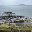
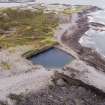
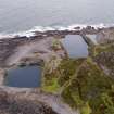
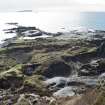
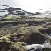
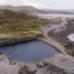
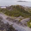
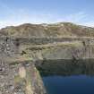
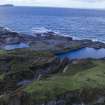
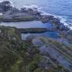
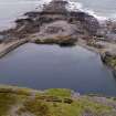
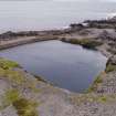
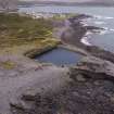
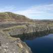
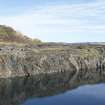
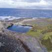
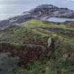
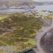
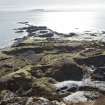
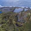
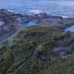
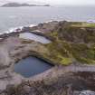
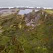
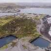
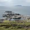
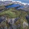
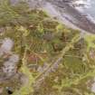
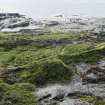
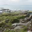
The expansion of quarrying on the north and west parts of Easdale took place between 1871 and 1899. This now flooded quarry, along with NM71NW 116 and NM71NW 117, is depicted and named on the 2nd edition Ordnance Survey 25-inch map (Argyllshire, surveyed 1898, published 1899, sheet CXXI.7).

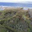
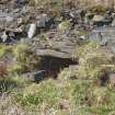
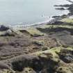
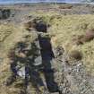
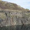
It is not depicted on the 1st edition Ordnance Survey 25-inch map (Argyllshire, surveyed 1871, published 1871, sheet CXXI.7). By 1899 it covers an area of some 1800 square metres (0.44 acres). It has also been connected to the tramway system (NM71NW 127) and is associated with buildings NM71NW 118.02 and structures NM71NW 118.01 and NM71NW 118.03 and the slate waste tip immediately to the south (centred NM73468 16963)..

As with other coast quarries on Easdale, this quarry was below sea level at the maximum extent of its working life. It has a retaining wall (see NM71NW 181.03). There is evidence that this quarry was still being worked in 1904.

Generally, quarrying on Easdale had ceased by 1914.

NRHE, MS/8087/3

Visited by HES, Survey and Recording Section, (MMD) 9 September 2015.

References

MyCanmore Image Contributions


Contribute an Image

MyCanmore Text Contributions