
Following the launch of trove.scot in February 2025 we are now planning the retiral of some of our webservices. Canmore will be switched off on 24th June 2025. Information about the closure can be found on the HES website: Retiral of HES web services | Historic Environment Scotland
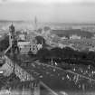
St Andrews Cathedral


Cathedral (13th Century)
Site Name St Andrews Cathedral
Classification Cathedral (13th Century)
Alternative Name(s) St Andrews Priory
Canmore ID 34299
Site Number NO51NW 2
NGR NO 51415 16687
Datum OSGB36 - NGR
Permalink http://canmore.org.uk/site/34299


First 100 images shown. See the Collections panel (below) for a link to all digital images.
- Council Fife
- Parish St Andrews And St Leonards
- Former Region Fife
- Former District North East Fife
- Former County Fife
NO51NW 2 51415 16687
NO51NW 2.01 51347 16579 Guest Hall
NO51NW 2.02 5147 1656 Granary
NO51NW 2.03 5148 1650 Abbey Mill
NO51NW 2.04 5149 1656 Well: Holy
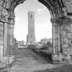
NO51NW 2.05 51475 16648 St Rule's Church and St Rule's Tower (St Regulus Church)
NO51NW 2.06 51369 16631 Priory House House
NO51NW 2.07 5142 1662 Museum
NO51NW 2.08 51459 16661 Burial Ground
NO51NW 2.09 5138 1662 Refectory; watching brief
NO51NW 2.10 51437 16581 Abbey Walls
NO51NW 2.11 51491 16571 Well House
NO51NW 2.12 51413 16619 Priory
(Centred NO 5139 1667) Cathedral (NR) (Ruins of (NAT)
OS 6" map (1912/38)
For description and history, see MoW Official Guide.
S Cruden 1950
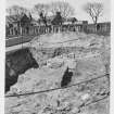
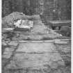
The problem of stagnant water in the cellar of the monastic S range prompted the examination of drainage in the adjacent cloister alley. Within the excavated areas no evidence of medieval occupation had survived the attentions of previous, similarly intentioned investigators.
J H Lewis 1987
NO 5145 1659 Minor archaeological excavations were undertaken in July 2004 comprising four trial trenches across the line of an intended trench for a waste water pipe. The archaeological potential of this area of the monument is affected by the extensive clearance and landscaping of the cathedral and graveyards from the Victorian period onwards.
Archive to be deposited in the NMRS.
Sponsor: HS.
D Stewart 2004
NS 5138 1663 A watching brief was undertaken in May 2005 during the excavation of a cable trench along the W and S walks of St Andrews Cathedral cloister, with 42m of trench in the S walk and 15m in the W walk, and a maximum depth of 0.5m.
This area has been subjected to improvements during the 18th and 19th centuries resulting in new surface levels. The old paved surfaces of the walkways had long been removed, with later 18th century levelling material added. Works in the 19th century to the S undercroft had greatly disturbed the walkway bottoming deposits and 18th-century levelling, with 20th-century conduit work disturbing both 18th- and 19th-century works. These excavations were not deep enough to penetrate late disturbances.
Archive to be deposited in NMRS.
Sponsor: HS.
D Stewart 2005
NO 5141 1668 A watching brief was undertaken in August 2006 during the removal of four stone bollards and excavation of foundations for six new cast iron bollards. The removal of the stone bollards partially revealed possible flagged surfaces and the footings of the stone columns of the West Precinct wall. The works caused no disturbance to these features. There were no other features of archaeological significance and no finds were retained.
Archive to be deposited in NMRS.
Sponsor: Historic Scotland.
Angus Mackintosh, 2006.
NO51NW 2.00 51415 16687
REFERENCE
SCOTTISH RECORD OFFICE
1805, Jan 23
St Andrews Cathedral. Order of barons of exchequer authorising repairs to'steeple' to be carried out under direction of Principal Hill.
SRO/E342/29
1825-7
St Andrews Cathedral and Castle. Letters and papers relating to conservation of ruins (11 items), including:
1. Letter from Robert Reid reporting on inspection of cathedral and castle and repairs needed at cathedral, 2 July 1825.
5. Letter from Reid on work at cathedral and additional work needed at castle; with report thereon, 19-23 Sept. 1823.
8. Account of John Kennedy, mason, for work at cathedral and castle, June 1826 - april [1827].
9. Letter from Professor Robert Haldane, St Andrews, on damage to sea wall at 'Dennis Wharf', 22 Nov. 1827.
10. Letter from Reid concerning sea wall and Kennedy's account, 15 Dec. 1827.
SRO/E342/38
Field Visit (16 June 1926)
The Cathedral and Cloister.
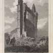
The Cathedral Church of St. Andrew, which was also the church of the Priory, was founded by Bishop Arnold and Malcolm IV in 1160 or 1161 (1). Rightly called "the great church," it was an aisled cruciform structure with a central tower and a high unaisled sanctuary of the type now known as the "canons' ending." Originally there were fourteen bays in the nave arcade, a greater number than is found in any other British church, except Norwich Cathedral. The main dimensions were then 391 feet from east to west by 168 feet from north to south. Even after its shortening, the structural nave is still the longest in Scotland and ranks with those of the largest churches across the border. The foundations of the whole church were laid at onetime, when also the walls were apparently all carried up a certain height. Progress on the new building was unusually slow, but the choir must have been finished by 1238, for in that year Bishop William Malvoisine was buried there (2); his predecessors had been laid to rest "in the old church," i.e. St. Rule's.
In the time of Bishop William Wishart (1273-1279) the west end of the church was thrown down by a tempest and was handsomely (sumptuose) rebuilt (3). In the reconstruction, however, the nave was reduced by two bays, making the present internal length 357 feet. This was effected by building the new gable 34 feet farther east. It is not properly bonded into the side walls, on which moreover the wall shafts of the discarded bays can still be seen, the additional space gained having been at one time utilised as a porch. Wishart is further credited with nearly "al the body of the kyrk," that is, almost the whole of the nave, and therefore with having completed the edifice - "his kyrk he endit cathederalle" (4). On the south side of the west door is the sadly mutilated head of an ecclesiastic wearing a mitre, which in all probability represents the Bishop himself. The whole structure was roofed with lead, but in 1304 Edward I stripped this off to use in the siege of Stirling, paying for it and providing material "to cover" the church (5). The "new cathedralle" was consecrated by Bishop Lamberton in July 1318 in the presence of King Robert the Bruce, seven bishops, fifteen abbots, and a large company (6).
Sixty years later, in the time of Bishop William de Laundelys or Landall (1341-85), the building was sorely damaged by a fire (7), and the most pressing work of repair took a little over seven years. The timber work of the choir and transepts (the "Corskirk " or cross-kirk) had to be replaced and these divisions roofed with lead. Two new piers were made in each transept aisle, and one "quarter," i.e. side, of the "stepil of stane " was constructed before the seven years were finished. In "the body of the kyrk," or nave, the nine piers on the south side eastwards of the west door were rebuilt, and on these were placed the arms of the different lords who had contributed to the expense (8). Prior James Bisset (1393-1416) supplied the timber work of the nave, completing the roof and other woodwork as well as fitting the choir with stalls (9).
In 1409 the gable of the south transept was thrown down by a great storm, and its stones crashed through the dormitory roof of the Priory (10). Meantime the nave, though now covered in, remained empty and bare till Prior James Haldenston (1419-1443) equipped it with windows of glass, as well as with altars, images and furnishings, and laid it with smooth pavement, which he further carried over the floors of the whole church. He is also said to have "built from the foundations the east gable with its vault” (11), but only the window in the gable and the vaulting, which can still be traced, are of his time. For the next hundred years the fabric required only minor repairs. After the Reformation it was allowed to fall into decay.
[see RCAHMS 1933, 230-7, for a full description of the church, monastic buildings, tombs and glass]
RCAHMS 1933, visited 16 June 1926.
(1) Scotichronicon; lib. VI, cap. xxxv. (2) Ibid., VI, xlii. (3) Ibid., VI, xliii. (4) Wyntoun's Orygynale Chronykil, Bk. VII, chap. x. (5) Bain's Calendar of Docts., ii, ,Nos. 1654, 1687. (6) Wyntoun, Bk. VIII, chap. xx. (7) Scotichron., VI, xlvi; Wyntoun, IX, v. (8) Wyntoun, IX, v. (9) Scotichron., VI, Iv. (10) Ibid., XV, xxi. (11) Ibid.VI, lvii. (12) Ibid., VI, 1. (13) Ibid., VI, Ii. (14) Ibid , VI.
Publication Account (1981)
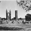
The Cathedral church and priory of St. Andrews is a successor to the adjacent church of St. Regulus. Bishop Robert's successor founded the cathedral church in 1160 x 1161. Although the choir was completed by 1238, the church itself was not consecrated until 1318. Before its consecration, storm damage ruined the west front and it was subsequently rebuilt by Bishop Wishart (1273 x 1279). This reconstruction reduced the overall length of the nave by thirty four feet (10.36m) (RCAM, 1933, 231). Fire caused havoc in the choir and transepts in the later fourteenth century, while storms badly lashed the building in the early fifteenth century. After the Reformation, the cathedral was allowed to decay, and even as late as the 1770s, as Dr. Johnson savagely observed, 'every man carried away the stones who fancied that he wanted them' (Baynes and Campbell, 1887, 144).
The remains of the church are very incomplete. Although the east gable is nearly entire, less than half the west gable is complete. Of the choir, the north wall has been reduced to its foundations although some remains of the south wall are above ground. Little remains of the north side of the nave wall, although the South wall is nearly entire. Excavation has uncovered the missing parts which are marked out clearly in the turf (RCAM, 1933, 231).
Information from ‘Historic St Andrews: The Archaeological Implications of Development’ (1981).
Publication Account (1987)
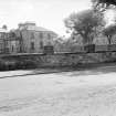
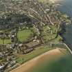
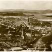
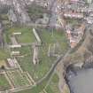
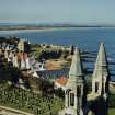
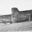
St Andrews Cathedral was an Augustinian foundation, the original community being brought to the Church of St Rule, St Andrews, about 1127. The building of the present cathedral began in 1160 on a site adjoining St Rule's Church. The cathedral church was set on a grand scale with an internal east·west dimension of over 109 m. This makes it one of the longest churches ever built in Britain and by far the greatest church in Scotland. Unfortunately very little now survives apart from the ruined gables and parts of the south wall. The monastic buildings to the south of the church are even more ruinous apart from a remarkably well preserved precinct wall; it encloses about 12.14 hectares and is 1.6 km long, 6.1 m high and 0.8 m thick, fortified by a series of attached towers, some round and others rectangular.
After the foundation of the cathedral and priory in 1160, building work followed the usual sequence, building in height from the east end towards the west front The choir was completed prior to 1238 when Bishop Malvoisine was buried there. The great west front was destroyed in a storm and rebuilt between 1273 and 1279. Work may have been delayed by the Wars of Independence but the 'new kyrk cathedralle' was consecrated by Bishop Lamberton in 1318 in the presence of King Robert Bruce.
The second half of the 14th century saw the greater part of the cathedral destroyed by fire. The timber work of the choir and transepts had to be renewed as did a number of piers in the nave and transepts. The urgent work of consolidation took seven years to complete and the total damage was not remedied until 1440. From then until the Reformation the church required only minor repairs. After the Reformation, when it suffered the burning of images and mass-books and the breaking of altars, it was allowed to fall into decay. In 1826 the Barons of the Exchequer took possession of the ruins and in 1946 it was given to the State.
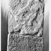
A museum was established in an isolated building commonly called the Prior's House. Included amongst the sculpture housed in the museum is an important example of late 8th or early 9th century work known as the St Andrews Sarcophagus, although its function is more likely to have been that of a shrine or reliquary rather than a normal coffin. It is a stone box,composed of slabs slotted into corner-posts, and its reconstructed gabled roof is conjectural. This is the earliest sculpture surviving from St Andrews, despite its formidable ecclesiastical history; perhaps all trace of an earlier Dark Age church settlement was destroyed at the Reformation.
The Sarcophagus consisted originally of four thin sandstone panels fitting into the grooved sides of four substantial corner-posts, but only two panels and three posts have survived. Much of the carving has been carried out in remarkably high relief, and the main long panel represents a major work of David iconography: the human figures depict scenes from the biblical life of David, and their treatment shows strong Mediterranean influence. The large figure represents David rending the jaws of the lion, the figure on horseback wields a sword in his right hand and a falcon on his left and is under attack from a lion, while the standing figure has shield and sword. All three figures are dressed in elaborately draped clothing quite unlike the normal Pictish tunics. Exotic elements include the griffon devouring a mule to the left of the large figure of David and the pairs of monkeys depicted on the end-panel. The sculptor's mastery of interlace ranges from the animal interlace on the corner posts to the intricate patterning of the cross on the end-panel.
This skill in carving interlace can also be seen on the great cross-shaft (no. 14), where all four sides of the shaft are covered in beautifully executed woven ribbons, and on the shaft of another free-standing cross (no. 19), both of which may have been created in the 9th century. They reflect, together with other sculptural fragments in the museum, the importance of St Andrews in the early medieval period.
St Rule's Church stands to the south-east of the cathedral. The narrow proportions of the church, its solid walls and minimal windows, suggest similarities to Northumbrian building practice of pre-Norman Conquest date, although it was probably erected towards the end of the 11th century. The tall square tower with round headed two-light windows also belongs to the late Anglo-Saxon or early Anglo-Norman period. There are similarities between this tower and the tower at Restenneth Priory (no. 65). The church towers at Dunning (NO 019144), Markinch (NO 297019) and Muthill (NN 867170) have similar two-light windows.
The foundations of the 12th century Culdee church of St Mary of the Rock (NO 515166) can be seen to the east of the cathedral and St Rule's Church, between the perimeter wall and the harbour.
Information from ‘Exploring Scotland’s Heritage: Fife and Tayside’, (1987).
Excavation (6 December 2004 - 7 December 2004)
In December 2004 Kirkdale Archaeology completed the Drain excavations at St Andrew's Cathedral which they had done trial trenching for earlier in the year.
G Ewart 2004
Sponsor: Historic Scotland
Kirkdale Archaeology
Watching Brief (12 July 2004 - 21 July 2004)
NO 5145 1659 Minor archaeological excavations were undertaken in July 2004 comprising four trial trenches across the line of an intended trench for a waste water pipe. The archaeological potential of this area of the monument is affected by the extensive clearance and landscaping of the cathedral and graveyards from the Victorian period onwards.
D Stewart 2004
Sponsor: Historic Scotland
Kirkdale Archaeology
Watching Brief (11 May 2005 - 12 May 2005)
NS 5138 1663 A watching brief was undertaken in May 2005 during the excavation of a cable trench along the W and S walks of St Andrews Cathedral cloister, with 42m of trench in the S walk and 15m in the W walk, and a maximum depth of 0.5m.
This area has been subjected to improvements during the 18th and 19th centuries resulting in new surface levels. The old paved surfaces of the walkways had long been removed, with later 18th-century levelling material added. Works in the 19th century to the S undercroft had greatly disturbed the walkway bottoming deposits and 18th-century levelling, with 20th-century conduit work disturbing both 18th- and 19th-century works. These excavations were not deep enough to penetrate late disturbances.
Fabric Recording (June 2008)
NO 51415 16687 This is a substantial collection of carved stone, and most of the examples are of a very high quality. It includes large numbers of column capitals dating from the 12th to 16th century, as well as numerous tomb slabs, voussoirs, vault ribs and sculptural pieces. One of the most interesting finds in this collection is an early 13th-century column base. It is possible that this stone was never used, since its moulded edge has an unfinished appearance, and some areas on the upper face are rather roughly finished. In addition, three sub-bases on the upper surface are irregular in appearance, with a notable asymmetry. The underside of the base shows intriguing evidence of design processes in the early 13th century. There are several drawn and scribed lines, showing the design of the sub-bases on the upper surface, as well as plans of walls with attached columns. Compasses have been used to form the column design, which was initially drawn, then scribed for use as a template. Measuring both the scribed/drawn template and the quatrefoiled bases on the upper surface shows that they are almost exactly the same size, providing a very rare example of both a planned and executed design. An assessment of the collection began in June 2008 and is ongoing.
This and other inventories of carved stones at Historic Scotland’s properties in care are held by Historic Scotland’s Collections Unit. A publication with a full discussion of this stone is currently in preparation. For further information please contact hs.collections@scotland.gsi.gov.uk
Funder: Historic Scotland
Mary Márkus – Archetype
Fabric Recording (June 2008 - March 2010)
NO 51415 16687 This collection of a large number of post-reformation tomb slabs and a group of architectural fragments was catalogued June 2008–March 2010 and is now on display in the cathedral museum. Among the architectural fragments are two very well preserved pieces of cornice. One of these shows a series of grotesque heads connected by a stem of vegetation. The stem is portrayed descending through the top of each head and re-appearing through the mouth to descend to the head below. The cornice is worked in very fine-grained sandstone, which has allowed the detail to be carved with a great degree of freedom and delicacy. The other cornice is more stylised in form, with a row of rectangular foliage and berry forms, again connected by a stem of vegetation. The coarser grade of this sandstone has clearly affected the manner of the carving, with a stronger sense of regularised pattern-making compensating for the relative simplicity of the carved detail. Among the tomb slabs, there are many fine examples of symbols of mortality, trades, heraldry and inscriptions, such as the tomb of Christian Wood (d 1636), which includes a skeleton with ‘memento mori’ on a scroll above its head.
This and other inventories of carved stones at Historic Scotland’s properties in care are held by Historic Scotland’s Collections Unit. For further information please contact hs.collections@scotland.gsi.gov.uk
Funder: Historic Scotland
Mary Márkus – Archetype
Standing Building Recording (8 September 2008)
Kirkdale Archaeology undertook a day long Standing Building Recording in September 2008 on the West Range Vault of St Andrews Cathedral.
G Ewart 2008
Sponsor: Historic Scotland
Kirkdale Archaeology
Watching Brief (5 May 2010 - 11 June 2010)
NO 513 166 (centred on) A watching brief was maintained during the digging of four trenches to house new sign boards at St. Andrews Cathedral, Fife. A record was also made of the removal of an existing sign. As to be expected on a site of such historical importance with a long history of occupation, even these relatively shallow trenches threw up evidence from the distant past in the form of a fragment of medieval floor tile. Little else of archaeological significance was recovered during the course of these works, however given the site's importance and the undoubted extensive archaeological deposits that survive relatively close to the ground surface, any future ground-breaking works should be carried out under close archaeological supervision.
Information from Oasis (kirkdale1-279400) 10 July 2018
G Ewart 2010
Sponsor: Historic Scotland
Kirkdale Archaeology
Excavation (26 September 2016)
Under the terms of its PIC call-off contract with Historic Scotland, Kirkdale Archaeology was asked to carry out an archaeological watching brief in the cemetery of St. Andrew's Cathedral during the excavation of three small trenches to house stone plinths on which new information boards could be attached. All three trenches revealed a similar sequence of topsoil over a similar soil with mortar and stone inclusions. This basal deposit may well represent the disturbed soil of the cemetery. No bone was seen, and nothing of archaeological significance was found.
G Ewart 2016
Sponsor: Historic Scotland
Kirkdale Archaeology
Project (22 March 2018 - 26 April 2018)
NO 51415 16687 A programme of geophysical survey was undertaken, 22 March – 4 April 2018 (Phase 1) and 23 – 26 April 2018 (Phase 2), within and around St Andrews Cathedral, the adjacent graveyard and St Mary on the Rock, which lies just to the E of the cathedral graveyard. A total area of 1.8ha of gradiometry and resistance data and 1ha of GPR data were collected.
Gradiometer and resistance surveys were carried out within and around the cathedral complex and at St Mary on the Rock; GPR survey was undertaken within the graveyard to the N and E of the cathedral.
Survey within and around the cathedral has recorded a wide variety of responses. However, the majority of these appear to be associated with past excavation, landscaping and consolidation of the site. Several anomalies have been detected which relate to more recent occupation of the site and show good correlation with earlier maps. However, the resistance survey has detected several well-defined anomalies which indicate the potential for some survival of buried in situ structural remains of archaeological significance. More ephemeral responses have also been noted which suggest earlier layouts of the cloister area.
The results from the survey over St Mary on the Rock are dominated by responses from modern landscaping of the area. However, one very well-defined linear anomaly has been noted which may be associated with remnants of the southern transept of the church.
The GPR survey of the graveyard indicates extensive burials of potentially different phases. Two possible structures have been detected that may be of archaeological interest. There is evidence within the data for a potential structure, c20 x 8m on an E/W alignment situated between the cathedral and St Rules Tower. A further well-defined anomaly has been recorded to the N of the cathedral and suggests a possible 10 x 4m feature at some depth. The origin of this anomaly is not clear, but its strength suggests it may be due to a void or at least very ‘hard’ material such as a discrete area of rubble or flooring.
Archive: Rose Geophysical Consultants
Funder: CFA Archaeology on behalf of HES
Susan Ovenden – Rose Geophysical Consultants
(Source: DES Vol 19)
Magnetometry (22 March 2018 - 26 April 2018)
NO 51415 16687 Magnetometry survey.
Archive: Rose Geophysical Consultants
Funder: CFA Archaeology on behalf of HES
Susan Ovenden – Rose Geophysical Consultants
(Source: DES Vol 19)
Ground Penetrating Radar (22 March 2018 - 26 April 2018)
NO 51415 16687 Ground penetrating survey.
Archive: Rose Geophysical Consultants
Funder: CFA Archaeology on behalf of HES
Susan Ovenden – Rose Geophysical Consultants
(Source: DES Vol 19)
Earth Resistance Survey (22 March 2018 - 26 April 2018)
NO 51415 16687 Resistance survey.
Archive: Rose Geophysical Consultants
Funder: CFA Archaeology on behalf of HES
Susan Ovenden – Rose Geophysical Consultants
(Source: DES Vol 19)
Watching Brief (5 November 2018 - 22 November 2018)
NO 51390 16676 (centred) A watching brief was undertaken during the installation of floodlighting at St Andrews Cathedral (PIC 035) in November 2018. This included lighting around the cathedral and St Rules tower. The 350m of trench followed the cable trench of previous lighting, which was installed during the 1990s. No significant archaeology was uncovered.
Archive: NRHE (intended)
Funder: Historic Environment Scotland
Leah Watt - CFA Archaeology Ltd
(Source: DES Vol 20)
OASIS ID: cfaarcha1-335043
Watching Brief (15 February 2023)
NO 51407 16586 An archaeological watching brief was undertaken comprised of watching the excavation of four test pits. Four test pits were excavated to investigate the existing gate pillar and investigate services. Several small finds were recorded from the made ground and are likely to be modern. No archaeological features were encountered during excavation.
Information from S. Swan - AOC Archaeology Group, 2023
OASIS ID: aocarcha1-515562

