
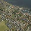
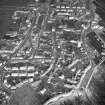
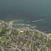
Pittenweem Harbour


Harbour (Period Unassigned)
Site Name Pittenweem Harbour
Classification Harbour (Period Unassigned)
Alternative Name(s) Mid Shore; East Shore
Canmore ID 34267
Site Number NO50SW 71
NGR NO 54968 02396
NGR Description Centred NO 54968 02396
Datum OSGB36 - NGR
Permalink http://canmore.org.uk/site/34267


- Council Fife
- Parish Pittenweem
- Former Region Fife
- Former District North East Fife
- Former County Fife
NO50SW 71.00 centred 54968 02396
Extends onto map sheet NO50SE.
Location formerly cited as NO 549 024.
Not to be confused with Pittenweem, Boat Harbour (landing place at NO 54705 02354), for which see NO50SW 476.00.
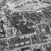
NO50SW 71.01 NO 54874 02224 to NO 54941 02335 to NO c. 55063 02441 SE Breakwater (East Pier)
NO50SW 71.02 NO 54939 02375 to NO c. 54836 02374 SW Breakwater (West Pier)
NO50SW 71.03 NO 54945 02389 to NO c. 55026 02465 Central Pier (Main Pier)
NO50SW 71.04 NO 54880 02385 West Basin
NO50SW 71.05 NO 54970 02443 Inner Basin
NO50SW 71.06 NO 55002 02401 Outer Harbour
NO50SW 71.07 NO 54876 02227 SE Breakwater, Beacon ('Pittenweem 2')
NO50SW 71.08 NO 54940 02335 E Pier, Beacon ('Pittenweem 1')
NO50SW 71.09 NO c. 54955 02392 Beacon ('Pittenweem 3')
NO50SW 71.10 NO c. 55022 02474 East Shore, Beacon
See also:
NO50SW 58 Pittenweem [General]
NO50SW 130 NO 54903 02411 Mid Shore, Harbour Granary
NO50SW 475 NO 54922 02437 Fish Market
Harbour [NAT]
OS 1:10,000 map, 1994.
NMRS Print Room
Pittenweem Harbour
4 prints - view from harbour wall
W Schomberg Scott Photograph Collection
Acc No 1997/39.
(Undated) information in NMRS.
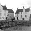
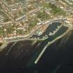
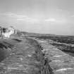
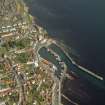
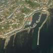
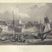
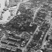
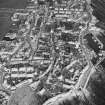
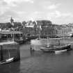
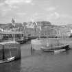
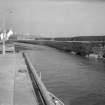
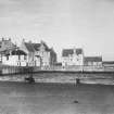
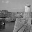
(Location cited as NO 549 024). Pittenweem, Fife: a charter of 1228 mentions revenue arising 'de portu maris de Pettynwem', but that does not imply that any built harbour existed at that time. The earliest construction may only have followed the erection of the town as a Royal Burgh in 1541, with power to build a harbour specifically provided, a confirmation of 1633 alluding to the 'reid, port, heavine and harberie'. Nothing has come to light about the nature of the earliest works, but in 1703 Adair noted that the harbour below the town was 'covered from Sea Storm by a long and strong Peer', and Roy's map (1747-55) marks this as curving towards the W from the E end of the bay. This pier still stands, as the main component of the harbour works, and formerly its head must have faced a quay, then based on the land to the W, but now incorporated in the head of the W pier, the entrance between them being noted in 1846 as 75ft [22.9m] wide. Early in the 18th century fresh construction began, with the help of a local tax on beer and ale obtained by a Member of Parliament, Sir John Anstruther. In 1721 negotiations were recorded with William Adam, described as 'architect in Lynktoun of Abbotshall', for the building of a pier which may safely be identified with the pier that formerly ran SW from the East Shore, through what is now the W basin. Work was still in progress on this pier in 1724, and even in 1729 the pier-head was still unfinished, while a heavy debt appears to have been incurred. Damage, decay and the necessary repairs are mentioned frequently in the record, but for the period later than 1724 it is difficult to be certain which pier is in question: in 1718 it must naturally have been the breakwater, and probably in 1747 likewise as the allusion was then made to 'the back of' the pier. It is worth noting that on both these occasions timber was required for the repairs, and timber is again implied by the 'ballerage' ['batterage' or buttressing] used in 1726, probably on the breakwater, as funds were not available for more permanent construction. The pier of 1721 was repaired and rebuilt in 1822, and is shown on the OS 6-inch map surveyed in 1854, but must have been removed after that date; its position is marked by a patch of concrete on the facing-wall of the East Shore quay, and its head, together with part of the quay W of the entrance, figures in an illustration of 1840. The entrance to the inner basin opened between this quay and the pier-head, and was 26ft [7.0m] wide. A local author alludes to repairs and improvements made in 1771, although without indicating their nature, but under this date the Burgh minutes only record that 'a part of the Peer', which was in danger of collapse, was to be taken down and rebuilt. Probably the breakwater is meant.
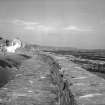
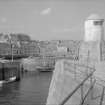
The breakwater is also a quay, although not, apparently, now used as such. It measures about 720ft [219.5m] in length, including its expanded landward end and some 80ft [24.4m] of pier-head built since 1854. The quay, apart from the expanded portion, is from 10ft [3m] to 12ft [3.7m] wide, its level and the alignment of its lip are irregular, it is paved with blocks set edgewise, and it carries three large, roughly squared, stone pawls set back against the face of the parapet. The masonry of the inner face is partly of squarish or vertical blocks and partly of random rubble. There has been a great deal of patching, as is frequently mentioned in the Burgh Records, and one patch has called for the construction of a relieving-arch. The parapet and the outer side of the pier seem more irregularly aligned than the inner face, no doubt because of irregularities in the rock below, and the outer face is supported in places with concrete. The parapet is 6ft [1.8m] to 9ft [2.7m] thick and up to 7ft [2.1m] high; the masonry is mortared, consisting mainly of blocks with occasional boulders, and has a flight of steps about 300ft [91m] out. The landward end seems to have been rebuilt or extended recently, and there is a concrete ramp in the E corner of the basin. A single unshaped stone pawl stands on the beach that has formed in this corner under the East Shore facing-wall.
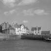
Apart from the scar left by the removal of the old internal pier, and some vertical masonry beside it, the East Shore quays show facing of irregular, patched rubble generally similar to that in the main pier. This contrasts strongly with the large, neatly dressed stonework of the W basin, which dates from after 1854. The SW side of this basin is formed by a pier, the head of which occupies the position of the former land-based quay mentioned above, and this pier-head has been extended in concrete construction towards the head of the 19th-century central pier, the entrance to the inner basin, with chases for booms, passing between them. The pawls on the W basin, apart from one well-shaped stone example, are either of cast-iron, with turned-over tops, or are iron pipes filled with cement, while the older ones, on the East Shore, are of stone. The cast-iron pawls, which also appear on the central pier, are inscribed ABBOTSHALL FOUNDRY KIRKCALDY in raised letters.
By the entrance to the W basin, there stands a fine granary (NO50SW 130) of 18th or early 19th century date.
A Graham 1971.
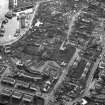
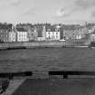
(Location cited as NO 550 023). Pittenweem Harbour, late 19th century. Two piers with angled heads, forming two basins with the shore. An outer pier, acting as a breakwater, lies parallel to the eastern pier.
J R Hume 1976.
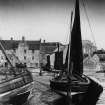
Carved stone numbers on top of E pier denote where and when fish would be sold and which boats were working. These were formerly located on the W pier.
Information from J Horsburgh/R McIntosh through Professor T C Smout, November 1996.
Site recorded by Maritime Fife during the Coastal Assessment Survey for Historic Scotland, Kincardine to Fife Ness 1996.

