
Cossans, 'st Orland's Stone'


Cist (Period Unknown)(Possible), Cross Slab (Pictish), Grave(S) (Period Unknown)(Possible), Pictish Symbol Stone (Pictish), Coin(S) (17th Century)
Site Name Cossans, 'st Orland's Stone'
Classification Cist (Period Unknown)(Possible), Cross Slab (Pictish), Grave(S) (Period Unknown)(Possible), Pictish Symbol Stone (Pictish), Coin(S) (17th Century)
Alternative Name(s) Glamis, St Orland's Stone
Canmore ID 33868
Site Number NO45SW 4
NGR NO 40083 50019
Datum OSGB36 - NGR
Permalink http://canmore.org.uk/site/33868


- Council Angus
- Parish Glamis
- Former Region Tayside
- Former District Angus
- Former County Angus
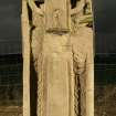
Cossans, Angus, Pictish cross-slab
Measurements: H 2.36m, W 0.69m, D 0.25m
Stone type: sandstone
Place of discovery: NO 4008 5002
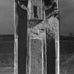
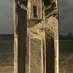
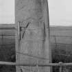
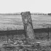
Present location: in situ within a railed enclosure in a field.
Evidence for discovery: first recorded in or before 1832, by which time it had broken into two fragments, which had been clamped together with one iron clamp on face A and two clamps on face C, and the stone had been re-erected. Sometime in the mid twentieth century, the early clamps were replaced by clamps along each narrow face and the stone was re-set in concrete. Excavations around the stone have taken place in 1855 and 2010, and the stone was again re-set in 2011.
Present condition: the stone is very weathered and there is damage to the edges and where the stone broke into two, together with damage associated with the early clamps.
Description
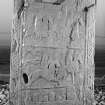
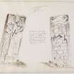
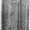
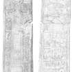
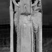
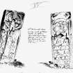
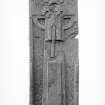
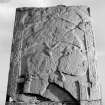
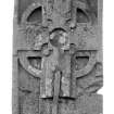
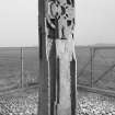
This is a complex and sophisticated monument, carved in relief on three levels. The narrow faces are dressed but plain, and both broad faces bear intricate ornament which is in need of modern analysis (at present the ECMS account is the most detailed). Face A has a flat-band border with key pattern ornament and a ringed cross which spans the length and breadth of the slab, its arms overlapping the border. The cross has been carved on two levels to accentuate the impression of a free-standing cross, and both levels are heavily ornamented, including the rectangular base. At the centre of the cross-head is a sunken circle with knobs projecting into the armpits, and it is likely that this recess was designed to receive a decorative metal boss. The background to the cross is carved with entwined and confronted fish monsters.
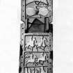
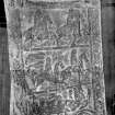
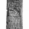
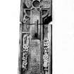
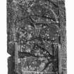
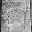
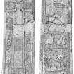
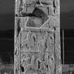
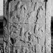
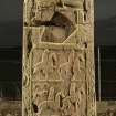
Face C has a wide flat-band border carved with the ribbon-like body of two creatures with fish-tails at the base of the slab, outlined by roll mouldings and filled with interlace. Towards the top of the slab, each creature extends a foreleg to support a circular object between their jaws, perhaps a human head. The space enclosed is edged and dived into four panels by roll mouldings. At the top are two large symbols decorated with spiral patterns: a crescent and V-rod over a double disc and Z-rod. Beneath them is a panel with a specially prominent decorated rectangular frame, open at the top, which encloses an irregular sunken area. An important carving may have been removed in the past (there is space for a horseman), or the recess may have held a portable panel.
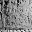
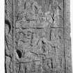
The lower three panels contain firstly two horsemen riding towards the right, and secondly another two horsemen accompanied by two hounds, all moving to the right. The lowest panel contains a rowing boat above two quadrupeds. There are six people in the boat: a steersman at the back holding the rudder, a small figure in front of him, then a larger oarsman facing towards the back of the boat, another small figure facing front, another backward-facing oarsman and, in the prow, a particularly large figure. The prow appears to bear a zoomorphic terminal (these details have emerged from Ian Scott’s drawing of the panel). Beneath the boat are two confronted animals, on the left a young steer and on the right an animal with an arched back and exaggerated dewlap claws.
Date range: ninth century.
Primary references: Skene 1832, 16; Jervise 1856, 248-51; ECMS pt 3, 216-18; Fraser 2008, no 56.
Desk-based information compiled by A Ritchie 2018
NO45SW 4 4008 5001
(NO 4008 5001) St Orland's Stone (NAT)
Cross Slab (NR)
OS 6" map (1969).
St Orland's Stone: A Class II upright cross-slab of Old Red Sandstone, nearly rectangular, 7'9" high, 2'4" wide at base, tapering slightly towards the top, and 10" thick.
It bears on one face a full length cross in relief and a variety of interlaced patterns in low relief. On the other face is an assemblage of figure scenes - mounted hunters, men in a boat and two animals - and symbols including the crescent and V-rod, double disc and Z-rod.
J R Allen and J Anderson 1903; V G Childe and W D Simpson 1954.
Field Visit (8 September 1958)
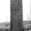
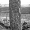
A large cross-slab standing on the east edge of an E-W ridge and protected by an enclosure fence. A plaque states that it dates from the 8th or 9th century AD.
Visited by OS (JLD) 8 September 1958.
Note (1983)
St Orland's Stone, Cossans NO 400 500 NO45SW 4
This Class II Pictish cross-slab stands 700m ENE of Cossans steading; the carvings on the back of the cross include a crescent with a V-rod, a double-disc with Z-rod, horsemen and a boat containing six figures. Excavations in 1855 revealed six inhumations, five of them in cists and none more than 3.6m from the stone; the cists, which were built of small flagstones, were all aligned E-W, and they contained crouched burials with the heads laid to the W. Previously, about 1842, several other cists were found nearby.
RCAHMS 1983
(Stat. Acct., iii, 1792, 126; Stuart 1856, 26, plate lxxxv; Jervise 1857b, 248-51; Allen and Anderson 1903, iii, 216-18; Coutts 1970, 55, no. 8).
Publication Account (1987)
Traditionally known as St Orland's Stone, this impressive slab stands to a height of almost 3 m on a low rounded knoll; it was set up in the late 8th or early 9th century, and there are old records of stone cist-graves having been found close by. Its location suggests that it marked a boundary in the same way as the comparable cross-slab at Aberlemno (no. 69), as well as acting as a focus for burials. Eleven hundred years of weathering in this exposed position have damaged the sculptor's work, but this is nevertheless a particularly interesting stone, chiefly for its rare carving of a boat
The entire length of the face of the slab is taken up by a ring-headed cross with a splayed base; ingeniously, the sculptor has carved the cross on two levels of relief so as to give a three-dimensional impression of a freestanding cross. The soft sandstone has allowed the creation of intricate spiral and interlace patterns over both levels of the cross, and an empty circular depression at the centre of its head may originally have held a decorative metal plaque. It seems likely that the knoll on which the monument stands was formerly surrounded by waterlogged marsh, and it is therefore very appropriate that the cross is itself surrounded by interlaced fish-monsters.
Two more fish-tailed beasts form a frame round the reverse side of the slab, enclosing, at the top, a crescent and V-rod and a double disc and Z-rod and figural panels below. An intriguing problem is posed by the central panel with its neatly cut recess: has some powerful symbol been deliberately removed? It must have been something important, for it had its own special decorative frame, open at the top as if to signify some connection with the symbols above. Below are two horsemen, each with a saddlecloth, and below them another pair of horsemen accompanied by two hunting dogs. Next comes the boat, a long vessel with upturned prow and stem, carrying at least four people and some large object in the prow. Unlike the boat carved in Jonathan's Cave (no. 78), no oars are depicted here, nor is there a sail. At the foot of the slab are carved two battling animals, one homed and the other cat-like, with pronounced claws and furiously arched back.
Information from ‘Exploring Scotland’s Heritage: Fife and Tayside’, (1987).
Reference (1997)
Class II symbol stone. On the reverse are a detailed illustration of a ship and a scene with mounted figures and hounds.Below are a crescent and V-rod above a double disc and Z-rod.
A Mack 1997.
Excavation (14 August 2008 - 18 August 2008)
NO 4008 5001 A series of small-scale excavations was carried out 14–18 August 2008 around St Orland’s stone, a ‘Class II’ Pictish stone. This spectacular cross slab sits at the E end of an E/W sandy ridge, overlooking low-lying marshy ground to the E. The stone has been in this position since at least the late 18th century and excavations in the mid 19th century by Jervaise (1859) revealed a series of six crouched inhumations, all but one in stone cists to the SW of the stone. The stone was enclosed by a metal fence and reset in 1952.
Excavation aimed to determine if the stone was in its original location and find the extent of previous investigations at the site. The slab remained in situ and was braced by scaffolding during this work, which involved two trenches c2m2 within the fenced enclosure, and a series of test pits outside this to provide context.
The cross slab had been reset with concrete running under the base of the stone, and the stone and the ground level within the fence raised 0.3–0.4m. The stone was tapered at its base, coming to a point at its S end 0.6m below the current ground surface and rising to the N. In the SE trench a partly exposed cut feature below the stone may have been an earlier socket, but further excavation would be required to confirm this.
Disturbed soils to the E of the slab were interpreted as part of Jervaise’s excavation, although three 17th-century coins recovered from a layer above this may indicate that this reflects even earlier work. Archaeological deposits below this, including a cut feature at the E end of the trench, indicate that significant deposits survive in this area. In the NW trench a pair of human tibia (not lifted) oriented E/W below a sandstone slab indicate the presence of surviving, albeit damaged, burials. A possible further cist cover (not raised), and two possible unlined graves in the W section were also recorded in this trench.
Both trenches produced evidence of an earlier circular fence around the stone, comprising massive slabs in which fence posts were set, truncating the W end of the human tibia. Test pits were dug to N, E, S and W, with those to the N and W revealing probable ploughsoil over sandy subsoil. To the E (coming off the ridge) darker hill-wash and gleyed soils were encountered, while to the S a more complex sequence of ploughed or windblown deposits was recorded.
Jervaise, A (1859) ‘Notices descriptive of the localities of certain sculptured stone monuments in Forfarshire (Part 1)’, Proc Soc Antiq Scot, 2, 1854–7, 248–51.
David Murray 2008
Sponsor: Historic Scotland
Kirkdale Archaeology
Excavation (16 October 2008)
Kirkdale Archaeology undertook a short one day excavation as a follow up to the work done in August.
D Murray 2008
Sponsor: Historic Scotland
Kirkdale Archaeology
Project (17 February 2009 - 6 March 2009)
NO 40083 50019 Geophysical surveys using a fluxgate gradiometer (80 x 100m), resistivity (40 x 60m) and ground-penetrating radar (50 x 30m), were undertaken on 17 February–6 March 2009, in a field adjacent to the St Orland’s Stone Pictish cross slab. Features included two possible sub-circular enclosures and possible small barrows to the W of the cross slab. Disturbance adjacent to the SW of St Orland’s Stone may indicate the presence of burials and trenching associated with 19th-century excavations. In general the results were relatively poorly defined due to the background geology and the likely truncation of archaeological features during recent agricultural activity.
Archive: PKHT, RCAHMS, LAA, and OASIS: Scotland (all intended)
Funder: Kirkdale Archaeology Ltd and Historic Scotland
Oliver O’Grady – Perth and Kinross Heritage Trust
Earth Resistance Survey (17 February 2009 - 6 March 2009)
NO 40083 50019 G
Ground penetrating radar survey.
Archive: PKHT, RCAHMS, LAA, and OASIS: Scotland (all intended)
Funder: Kirkdale Archaeology Ltd and Historic Scotland
Oliver O’Grady – Perth and Kinross Heritage Trust
Magnetometry (17 February 2009 - 6 March 2009)
NO 40083 50019 G
Magnetometry survey.
Archive: PKHT, RCAHMS, LAA, and OASIS: Scotland (all intended)
Funder: Kirkdale Archaeology Ltd and Historic Scotland
Oliver O’Grady – Perth and Kinross Heritage Trust
Earth Resistance Survey (17 February 2009 - 6 March 2009)
NO 40083 50019 G
Resistivity survey.
Archive: PKHT, RCAHMS, LAA, and OASIS: Scotland (all intended)
Funder: Kirkdale Archaeology Ltd and Historic Scotland
Oliver O’Grady – Perth and Kinross Heritage Trust
Excavation (14 November 2010)
NO 40083 50019 An excavation was carried out on 14 November 2010 prior to the resetting of the St Orland’s Stone. The excavation, which was confined to a previously excavated area (DES 2008, 32) recorded no significant finds or features of archaeological significance.
Archive: RCAHMS (intended)
Funder: Historic Scotland
Kirkdale Archaeology, 2010
Information also reported in Oasis (kirkdale1-171096)

