
Pricing Change
New pricing for orders of material from this site will come into place shortly. Charges for supply of digital images, digitisation on demand, prints and licensing will be altered.
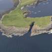
Stronsay, 'the Danes Pier'


Harbour (Period Unassigned)(Possible), Natural Feature (Period Unknown)(Possible), Pier (Period Unassigned)(Possible)
Site Name Stronsay, 'the Danes Pier'
Classification Harbour (Period Unassigned)(Possible), Natural Feature (Period Unknown)(Possible), Pier (Period Unassigned)(Possible)
Alternative Name(s) Hooonisskerrie; Pictish Pier; Danes Pier
Canmore ID 3382
Site Number HY62SE 9
NGR HY 6876 2142
Datum OSGB36 - NGR
Permalink http://canmore.org.uk/site/3382


- Council Orkney Islands
- Parish Stronsay
- Former Region Orkney Islands Area
- Former District Orkney
- Former County Orkney
HY62SE 9 6876 2142.
(HY 6876 2142) Pier (NR)
(HY 6879 2140) Harbour (NR)
OS 6" map, Orkney, 2nd ed., (1900).
A cancelled name for the 'pier' in the Ordnance Survey Name Book (ONB) is Hooonisskerrie.
Name Book, 1879
Thought to have been a 'Pictish' pier and harbour associated with the neighbouring broch (HY62SE 1), these features are entirely natural, although the possibility exists that the shoreward end of the 'pier' may have been used as such.
An officer of the Geological Survey (Scotland) who examined the 'pier' came to the conclusion that it owed its existance to the tide race which runs round Lamb Head.
RCAHMS 1946, visited 1928.
In spite of the persistent tradition of artificial construction, this remarkable L-shaped boulder-spit off the S side of Lamb Ness is nowadays dismissed as a natural formation. While there is certainly no indication of built structures, and the natural origin must be accepted, the parallel with features in Sanday and Papa Westray require that the matter be given further thought; see introduction of RCAHMS 1984.
H Marwick 1927; RCAHMS 1984, visited May 1983.
Field Visit (8 June 1928)
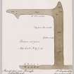
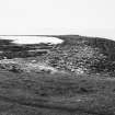
This massive and remarkable construction which stretches into the bay on the W side of Lamb Head and forms a very convenient shelter and harbour cutting off the heavy current and heavy seas that roll around this part of the coast is obviously of artificial and not natural construction and its proximity to Broch of Lamb Ness - only about 300-400 yards distant is extremely suggestive of some intimiate association. It is a work of great magnitude and while no definite traces of careful and systematic building were observed, at certain points on the inner side of the curve large boulders, apparently set in alignment as a margin within and upon which to heap the other materials for the structure were noticed beneath the water. Many of the stones used in constructing the pier are of fairly large size but there is a good mixture of shingle which may quite easily however have been washed there by heavy seas. The pier runs out into the bay in a somewhat oblique and slightly curved line bending at its outer extremity, as far as it can be followed, in a southerly direction, and it extends - it is said for a distance of over a quarter of a mile into the bay. At the time of my visit, only about half of that distance was visible owing to the tide at a distance of about twenty feet from the shore end. The pier has a width of approximately 65 feet and it widens gradually as it advances. It is impossible to ascertain definitely the height of the structure as much of it is underwater and the foundation probably somewhat silted up but it must at any rate in parts exceed 5 or 6 feet. The work of construction must have entailed an immense amount of labour and although the pier is conspicuous and greatly needs attention it is quite impossible to hazard a guess at the purpose for which it was made whether or not it has a connection with the neighbouring broch structure is a mystery which may never be solved. The construction might be planned or photographed at low tide when again visiting the broch.
Visited by RCAHMS (JMC) 8 June 1928
Transcribed from RCAHMS Notebook Orkney Nos 1 1928
Field Visit (13 June 1928)
This morning in response to a message called again to see Mr James Miller of Banks who wished to add some information in regard to the Danes Pier. He tells me that at low water there is every evidence that the pier originally formed a complete basin of half moon outline and was connected to the shore at its S extremity also. This portion has however, owing to the storms and strength of the currents in part destroyed. At low ebb tide in spring he finds that an ordinary small fishing boat will scarely float over the barrier but that immediately in crossing it you enter water 1 to 2 fathoms in depth. There is he finds one clear break of very limted extent that affords a free passage.
Visited by RCAHMS (JMC) 13 June 1928
Transcribed from RCAHMS Notebook Orkney Nos 1 1928
Field Visit (17 July 1970)
There are no indications to suggest that this feature is man-made or that it has been modified for use as a pier. It is known throughout Stronsay as 'The Danes' Pier'.
Visited by OS (NKB) 17 July 1970.
Field Visit (July 1979)
A spit of loosely-piled large stones, width 20-30m at low
tide, L-shaped, total length about 400m, the outer part of the L
submerged except at low tide. It is almost certainly formed by
two tidal streams which meet at this point.
Information from Orkney SMR (RGL) Jul 79, inf R Fotheringham, Whitehall.

