
Following the launch of trove.scot in February 2025 we are now planning the retiral of some of our webservices. Canmore will be switched off on 24th June 2025. Information about the closure can be found on the HES website: Retiral of HES web services | Historic Environment Scotland
Fortrose, Ness Gap


No Class (Event) (Period Unassigned)
Site Name Fortrose, Ness Gap
Classification No Class (Event) (Period Unassigned)
Canmore ID 332446
Site Number NH75NW 343
NGR NH 7329 5651
NGR Description F1: NH 7332 5660; F2: 7347 5657; F4: 7313 5634
Datum OSGB36 - NGR
Permalink http://canmore.org.uk/site/332446


![Evaluation photograph, Stone lined pit (019) and linear Feature [022], Ness Gap, Fortrose, Highland](http://i.rcahms.gov.uk/canmore/l/DP00419153.jpg)


![Evaluation photograph, Modern Pit [001], Ness Gap, Fortrose, Highland](http://i.rcahms.gov.uk/canmore/l/DP00419054.jpg)


![Evaluation photograph, Stone lined pit (019) and linear Feature [022], Ness Gap, Fortrose, Highland](http://i.rcahms.gov.uk/canmore/s/DP00419153.jpg)


![Evaluation photograph, Modern Pit [001], Ness Gap, Fortrose, Highland](http://i.rcahms.gov.uk/canmore/s/DP00419054.jpg)


- Council Highland
- Parish Rosemarkie
- Former Region Highland
- Former District Ross And Cromarty
- Former County Ross And Cromarty
Desk Based Assessment (July 2006)
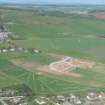
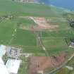
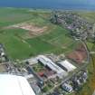
An archaeological desk-based assessment was carried out by Headland Archaeology on the site of a proposed housing development in the eastern margins of Fortrose, The Black Isle, Ross and Cromarty.
The assessment included a consultation of documentary and cartographic evidence within the Development Area, and within a wider Study Area, which generally extended 500m from the centre ofthe site. Outside of the Study Area, the Scheduled Ancient Monument, Fortrose Cathedral was included in this assessment due to its Designated Status.
Although no sites of cultural heritage interest are known within the proposed development area and cartographic evidence suggests that the area has remained an open field for a considerable period of time. There are no known archaeological sites within the proposed development area but the general area with its close proximity to the remains of Fortrose Cathedral has high potential for the survival of archaeological deposits. A road, which bounds the development area to the north would have been the main thoroughfare between the town and the nearby Chanonry Point from where a ferry plied to first to Ardersier, and later to Fort George in Morayshire. A footpath, which divides the development area, may also have been an important early route between the outlying farmland and the town and its market.
Archaeological Evaluation (20 September 2010 - 18 February 2011)
NH 7329 5651 An evaluation was undertaken 20–21 September 2010 on Phase 1a and 1b of a proposed housing development off Ness Road. A total of seven trenches were excavated but no significant archaeological features, deposits or artefacts were recorded.
Archive: RCAHMS
Funder: Tulloch Homes Ltd
Headland Archaeology Ltd, 2010
Archaeological Evaluation (21 September 2010 - 28 October 2010)
NH 7329 5651 An evaluation was undertaken 21 September 2010–18 February 2011 on Areas B–G of a proposed housing development off Ness Road. A total of 50 trenches were excavated and revealed a range of prehistoric features, including an urned cremation, a stone cist with a Bronze Age Food Vessel and a further possible cist. The cist and possible cist were close together but the urned cremation, which had been badly truncated by ploughing, was located almost 200m to the E.
Archive: RCAHMS
Funder: Tulloch Homes Ltd
Headland Archaeology Ltd, 2011

