
Following the launch of trove.scot in February 2025 we are now planning the retiral of some of our webservices. Canmore will be switched off on 24th June 2025. Information about the closure can be found on the HES website: Retiral of HES web services | Historic Environment Scotland
Clova Castle


Castle (Medieval)
Site Name Clova Castle
Classification Castle (Medieval)
Canmore ID 32423
Site Number NO37SW 1
NGR NO 32185 73352
Datum OSGB36 - NGR
Permalink http://canmore.org.uk/site/32423


- Council Angus
- Parish Cortachy And Clova
- Former Region Tayside
- Former District Angus
- Former County Angus
NO37SW 1 32189 73370.
(NO 3219 7336) Clova Castle (NR)
OS 6" map, (1972)
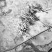
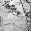
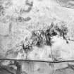
The remains of Clova-Castle are situated on a height above the Glen Road. The only extant position is the fragment of a circular stair tower which occupied the SE angle of the castle. The southern segment of this stands at a height of c.3.0m - the rest lay collapsed; but its diameter is c.4.0m, the wall being 1.0m thick. Abutting on the NE are the vague turf-covered foundations of a rectangular area measuring c.9m E-W x 7.7m N-S but undoubtedly the foundations of the main building - plan suggest a possible 16th century date.
A Jervise 1853; Name Book 1862; Visited by OS (J L D) 10 September 1958.
No recognisable rectangular foundations can now be seen to the NE of the tower, where turf-covered fallen masonry forms a mound c.1.3 metres high, c 14.0 metres E to W by c 16.0 metres transversely. An old track, c 1.5 metres wide terraced into the hillside from the W may be connected with the castle.
Surveyed at 1/2500
Visited by OS (R L) 20 November 1967.
Field Visit (15 June 1999)
NO37SW 1 32189 73370.
Clova Castle is situated in a pasture field immediately W of Mains farmsteading. The visible remains comprise a rectangular block measuring 11m from NW to SE by 9.2m transversely, but largely obscured beneath a mound of grass-grown rubble up to 1.5m high. The best preserved part of the castle is a circular tower projecting from the W corner. This measures 4.6m in diameter over a mortar-bonded rubble wall 1.2m in thickness, and stands 2.7m in height. The remains of a slit window are visible in its W side, 0.8m above ground level.
(CLOVA99 519)
Visited by RCAHMS (SDB, MFTR) 15 June 1999

