
Clova Castle


Castle (Medieval)
Site Name Clova Castle
Classification Castle (Medieval)
Canmore ID 32423
Site Number NO37SW 1
NGR NO 32185 73352
Datum OSGB36 - NGR
Permalink http://canmore.org.uk/site/32423


- Council Angus
- Parish Cortachy And Clova
- Former Region Tayside
- Former District Angus
- Former County Angus
NO37SW 1 32189 73370.
(NO 3219 7336) Clova Castle (NR)
OS 6" map, (1972)
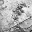
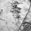
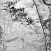
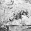
The remains of Clova-Castle are situated on a height above the Glen Road. The only extant position is the fragment of a circular stair tower which occupied the SE angle of the castle. The southern segment of this stands at a height of c.3.0m - the rest lay collapsed; but its diameter is c.4.0m, the wall being 1.0m thick. Abutting on the NE are the vague turf-covered foundations of a rectangular area measuring c.9m E-W x 7.7m N-S but undoubtedly the foundations of the main building - plan suggest a possible 16th century date.
A Jervise 1853; Name Book 1862; Visited by OS (J L D) 10 September 1958.
No recognisable rectangular foundations can now be seen to the NE of the tower, where turf-covered fallen masonry forms a mound c.1.3 metres high, c 14.0 metres E to W by c 16.0 metres transversely. An old track, c 1.5 metres wide terraced into the hillside from the W may be connected with the castle.
Surveyed at 1/2500
Visited by OS (R L) 20 November 1967.
Field Visit (15 June 1999)
NO37SW 1 32189 73370.
Clova Castle is situated in a pasture field immediately W of Mains farmsteading. The visible remains comprise a rectangular block measuring 11m from NW to SE by 9.2m transversely, but largely obscured beneath a mound of grass-grown rubble up to 1.5m high. The best preserved part of the castle is a circular tower projecting from the W corner. This measures 4.6m in diameter over a mortar-bonded rubble wall 1.2m in thickness, and stands 2.7m in height. The remains of a slit window are visible in its W side, 0.8m above ground level.
(CLOVA99 519)
Visited by RCAHMS (SDB, MFTR) 15 June 1999

