
Errol, Old Parish Churches


Burial Ground (Medieval) - (18th Century), Church(S) (Medieval)
Site Name Errol, Old Parish Churches
Classification Burial Ground (Medieval) - (18th Century), Church(S) (Medieval)
Canmore ID 30475
Site Number NO22SE 2
NGR NO 2520 2280
Datum OSGB36 - NGR
Permalink http://canmore.org.uk/site/30475


- Council Perth And Kinross
- Parish Errol
- Former Region Tayside
- Former District Perth And Kinross
- Former County Perthshire
NO22SE 2 2520 2280
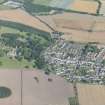
(NO 2520 2280) Church (NR) (Site of)
OS 6" map (1959)
For present parish church (at NO 2526 2295), see NO22SE 23.00.
This church was built about 1766, and was in use until 1831, when another church was built on a different site.
New Statistical Account (NSA 1845 J Griegson).
Field Visit (16 June 1964)
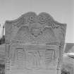
There are no traces of this church. In the graveyard are a number of stone coffins dating from 1639.
Visited by OS (WDJ) 16 June 1964.
Field Visit (21 June 1989)
The parish church of Errol is on record in the early 13th century but the medieval building had been replaced by the 18th century. An engraving of the church erected in the burial-ground in 1765 shows a large arch-pointed and traceried window incorporated in a small annexe or porch on its S side, suggesting the re-use of earlier material. The 18th century church was taken down when a new parish church (NO22SE 23) was built some 120m to the NNE in 1831. In the burial-ground there is a 17th century coped grave-cover, together with a number of 18th century gravestones. The mutilated effigy of a knight (NO22SE 23.01), probably of 15th century date, which was formerly fixed to the wall, is now in Perth Museum.
Visited by RCAHMS (PC, IMS), 21 June 1989.
Earth Resistance Survey (3 April 2007 - 11 April 2007)
NO 2520 2280 A resistivity survey of Errol Old Churchyard was carried out from 7–11 July 2007 to try and find any traces of the old, demolished, parish church. There is a large area of high resistivity material at the lower, NE part of the churchyard which might represent spoil of some sort. The church site is on the highest part of the area in a low resistivity zone. While some weak linear features parallel to the probable orientation of the
building can be seen it is not really possible to demonstrate the former extent of the structure.
Archive to be deposited with RCAHMS. Copy of report deposited with Perth and Kinross SMR.
Funder: Perth and Kinross Heritage Trust.

