
Spittal Of Glenshee


Cultivation Remains (Medieval) - (Post Medieval), Township (Medieval) - (Post Medieval)
Site Name Spittal Of Glenshee
Classification Cultivation Remains (Medieval) - (Post Medieval), Township (Medieval) - (Post Medieval)
Canmore ID 29653
Site Number NO17SW 6
NGR NO 1080 7039
Datum OSGB36 - NGR
Permalink http://canmore.org.uk/site/29653


- Council Perth And Kinross
- Parish Kirkmichael (Perth And Kinross)
- Former Region Tayside
- Former District Perth And Kinross
- Former County Perthshire
Field Visit (19 July 1968)
NO17SW 6 108 703.
Centred NO 108 703: Situated on a slight terrace above a gradual slope on which is extensive rig and furrow are the remains of a depopulated farmstead comprising thirteen buildings and several small associated enclosures. The buildings vary in size from 20.0m x 3.0m to 4.0m x 2.5m and are generally visible as grass-covered footings c0.5m high. No name or date of depopulation could be discovered. (Visible on air photographs RAF/AP/106G/SCOT/UK56:4138)
Visited by OS (RD) 19 July 1968
Field Visit (16 April 1987)
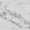
This fermtoun extends across the S-facing slope (NO 1071 7043 - 1090 7036), at the foot of the trees, on the N side of Glen Shee 200m NNW of Spittal church (NO17SW 11). It can be divided into six units each consisting of a yard with associated buildings. Their relationship to the head-dyke, which stretches virtually unbroken along the 380m contour, is noteworthy as it descends the slope on either side of the fermtoun (to be straddled by a number of buildings) and it is possible that the two are broadly contemporary. To the NW and on its uphill side, the head-dyke is respected by a slightly hollowed track up to 3m wide.
The yard areas, along with their associated buildings, at the extremities of the settlement (on the NW and SE respectively) appear to overlie earlier cultivation lynchets that extend downslope from the settlement; it is possible that both yard areas (1 and 6) are marginally later in date and represent an extension of the fermtoun over ground that had previously been cultivated.
The buildings are broadly similar in size and most have only one compartment. Of particular note, however, is a three-compartment rectangular building to the S of group 4. This building is proportionately larger than the rest and is set slightly apart from its neighbours.
To the S and W, extending obliquely down slope, there are a series of broad rigs, which take the form of lynchets (each at least 8m wide) as they traverse the slope; those in turn are overlain by later rig-and-furrow cultivation.
The extent of the fermtoun is delimited on Brown's survey of 1808 and is annotated 'Old house lets'.
1. NO 1076 7042 This unit consists of a yard with buildings on the W and S respectively. The first, an open-ended building, which is rectangular on plan (9.1m from NW to SE by 5.7m over turf-covered stone wall-footings 1.2m thick), has an entrance central to the SE side-wall. The second building measures 11.4m from WNW to ESE by about 5.4m over turf-covered wall-footings up to 1.2m in thickness. Its ENE wall has been entirely robbed.
2. NO 1077 7041 This unit comprises a slightly sunken yard with buildings on the NE and ESE respectively. The first, a two-compartment rectangular building (14.1m from NW to SE by 5.4m over turf-covered wall-footings 1.2m thick and up to 0.4m high), is terraced into the slope at the head of the yard robbing-out all traces of the head-dyke. The second building measures 8.4m from SSW to NNE by 4.5m over stone wall-footings 0.8m in thickness. Its ESE side-wall is overlain by the boundary-wall of an adjoining yard (3). To the N, and end-on to each other, there are the wasted remains of two buildings measuring respectively (from WNW to ESE) 8.6m by 4.1m over stone wall-footings 0.8m in thickness, and (possibly of two compartments) 9.2m by 5.1m over walls 1.2m in thickness and up to 0.3m in height.
3. NO 1080 7040 A yard with a two-compartment rectangular building on its NE side (11.5m from WNW to ESE by 4.9m over walls up to 1.2m thick and 0.2m high), which has been terraced into the slope; its SSW side wall has been severely robbed. A later boundary-wall connects with the ESE end-wall of the building and extends from WNW to ESE across the yard area, dividing the yard and delimiting the furthest extent of the hollowed track on the N side of the head-dyke.
4. NO 1082 7040 This unit comprises on two sides of a yard, that on the NNE of three compartments, possibly not all of the same date (22.4m from WNW to ESE by 5.4m over walls 1.2m thick and 0.4m high), and that on the W, measuring 8.9m from NNE to SSW by 5.3m over turf-covered stone wall-footings 1.2m in thickness.
5. NO 1085 7037 A yard with buildings on the S. The first, incorporated in the SW angle of the yard, measures 6.8m from WNW to ESE by 3.3m over stone wall-footings 0.6m in thickness. The S wall has been robbed and the WNW end-wall incorporated what may be a byre-drain.
To the SSE there are the wasted remains of a rectangular building which has been terraced into the slope. It measures 10.9m from WNW to ESE by 5.3m over stone wall-footings 0.7m in thickness. A pen (3.2m by 3m over stone wall-footings 0.8m thick) was subsequently constructed within the building.
End-on, there is a further building terraced into the slope. It has a slightly sunken interior and measures 11.1m from W to E by 4.6m over walls wasted by robbing spread up to 1.2m in thickness and 0.4m in height. The E end-wall is round-ended.
Immediately to the NE there are the remains of another building (6.7m from WNW to ESE by 4.3m over turf-covered stone wall footings 1m thick) with an entrance central to its SSW side-wall. A portion of bank adjoins the NNE side-wall and extends upslope to join the wasted remains of the old head-dyke (up to 2.6m thick and 0.8m high). Incorporated in its length there is a probable pen (8.4m from NW to SE by 3m over walls 0.7m thick). On the N the head-dyke has been cut away and overlying it at this point there are the wasted remains of a rectangular building, terraced into the slope, measuring 11.7m from WNW to ESE by 4.3m over stone wall-footings 1m in thickness.
6. NO 1085 7032 A yard with two possible buildings on its W side; that on the N (10.9m from NNW to SSE by 4.5m over stone walls spread up to 1.2m thick) has a slightly sunken floor, and that to the S (9m from N to S by 2.8m overall) has what may be an outshot (4.2m by 2.1m overall) central to its WNW side.
7. NO 1090 7036 A round-ended rectangular building (12.1m from NW to SE by 4.9m over turf-covered stone wall-footings 1.1m thick) occupies a knoll to the S of the old head-dyke. What may be a second building (represented by a shallow depression), 15m to the NNW, measures at least 7m from WNW to ESE by 2.5m overall. It is open-ended on the ESE but the wall at this point could have been robbed.
Visited by RCAHMS (IMS) 15, 16 April 1987.
RCAHMS 1990
Measured Survey (18 March 1987)
RCAHMS surveyed the fermtoun at Glen Shee on 18 March 1987 at a scale of 1:1250 with self-reducing alidade and plane-table. The plan was redrawn in ink and published at a scale of 1:2500 (RCAHMS 1990, Fig. 278.1A).

