
Ranageig


Cairn (Early Prehistoric)
Site Name Ranageig
Classification Cairn (Early Prehistoric)
Alternative Name(s) Ranageig 2
Canmore ID 28804
Site Number NO14NW 22
NGR NO 11298 49176
Datum OSGB36 - NGR
Permalink http://canmore.org.uk/site/28804


- Council Perth And Kinross
- Parish Blairgowrie
- Former Region Tayside
- Former District Perth And Kinross
- Former County Perthshire
Field Visit (16 January 1975)
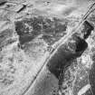
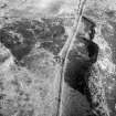
NO14NW 22 1129 4917.
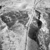
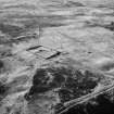
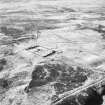
At NO 1129 4917 on a rise above a gully, is a partially robbed cairn measuring 12.0m in diameter and 1.0m high. Around the SW half are several displaced kerb stones. In the centre, the W and N slabs of a cist oriented E-W survive in situ. It has measured 1.3m x 0.9m x 0.6m deep.
Surveyed at 1:10 000.
Visited by OS (JM) 16 January 1975
Field Visit (4 March 1987)
This cairn is situated on a low knoll immediately N of the modern track and about 900m E of Ranageig farmhouse. It measures 11.8m in diameter over a kerb of boulders and up to 0.7m in height. The N and W slabs of a cist are visible near the centre; it measures at least 1.2m from E to W by 0.6m and 0.5m in depth.
Visited by RCAHMS (JRS) 4 March 1987.
RCAHMS 1990

