|
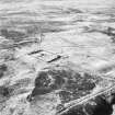
Photographs and Off-line Digital Images |
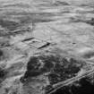
A 55481 |
RCAHMS Aerial Photography |
Oblique aerial view. |
1987 |
Item Level |
|
|
Photographs and Off-line Digital Images |
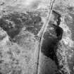
A 55482 |
RCAHMS Aerial Photography |
Oblique aerial view. |
1987 |
Item Level |
|
|
Photographs and Off-line Digital Images |
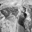
A 55483 |
RCAHMS Aerial Photography |
Oblique aerial view. |
1987 |
Item Level |
|
|
Prints and Drawings |
DC 14788 SO |
Records of the Royal Commission on the Ancient and Historical Monuments of Scotland (RCAHMS), Edinbu |
Overlay and base map showing distribution of sites in Middleton Muir area. RCAHMS 1990, 147 (NE Perth) |
|
Item Level |
|
 |
On-line Digital Images |
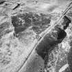
SC 385401 |
RCAHMS Aerial Photography |
Oblique aerial view. |
1987 |
Item Level |
|
 |
On-line Digital Images |
SC 385402 |
RCAHMS Aerial Photography |
Oblique aerial view. |
1987 |
Item Level |
|
 |
On-line Digital Images |
SC 1709822 |
RCAHMS Aerial Photography |
Oblique aerial view. |
1987 |
Item Level |
|
 |
On-line Digital Images |
SC 1709957 |
RCAHMS Aerial Photography |
Oblique aerial view. |
1987 |
Item Level |
|
 |
On-line Digital Images |
SC 1709958 |
RCAHMS Aerial Photography |
Oblique aerial view. |
1987 |
Item Level |
|
 |
On-line Digital Images |
SC 2398272 |
Records of the Ordnance Survey, Southampton, Hampshire, England |
Ranageig, NO14NW 22, Ordnance Survey index card, Recto |
c. 1958 |
Item Level |
|
 |
On-line Digital Images |
SC 2398273 |
Records of the Ordnance Survey, Southampton, Hampshire, England |
Ranageig, NO14NW 22, Ordnance Survey index card, Recto |
c. 1958 |
Item Level |
|
 |
On-line Digital Images |
SC 2398274 |
Records of the Ordnance Survey, Southampton, Hampshire, England |
Ranageig, NO14NW 22, Ordnance Survey index card, Recto |
c. 1958 |
Item Level |
|
|
All Other |
551 166/1/1 |
Records of the Ordnance Survey, Southampton, Hampshire, England |
Archaeological site card index ('495' cards) |
1947 |
Sub-Group Level |
|


