
Inchtuthil


Legionary Fortress (Roman)
Site Name Inchtuthil
Classification Legionary Fortress (Roman)
Alternative Name(s) Pinnata Castra; Inchtuthil Plateau
Canmore ID 28592
Site Number NO13NW 5
NGR NO 1251 3971
Datum OSGB36 - NGR
Permalink http://canmore.org.uk/site/28592


First 100 images shown. See the Collections panel (below) for a link to all digital images.
- Council Perth And Kinross
- Parish Caputh
- Former Region Tayside
- Former District Perth And Kinross
- Former County Perthshire
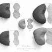
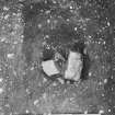
A floor tile from the fortress site has been donated to Perth Museum and Art Gallery (Acc No 1988.108).
A G Reid 1988.
NO13NW 5 1251 3971
For fort (NO 1152 3930) incorporating Roman stone, see NO13NW 6. For barrows at NO 1279 3968 and 1274 3968, see NO13NW 7.00.
NO13NW 5.00 NO 125 397 Roman Fortress
NO13NW 5.01 NO 119 394 Roman Temporary Camp
NO13NW 5.02 NO 1165 3934 Roman Temporary Camp
NO13NW 5.03 NO 1199 3966 to NO 1217 3927 Linear Earthwork
NO13NW 5.04 NO 125 397 Flat Bronze Axe
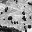
NO13NW 5.05 NO 1261 3989 Cinerary Urns
NO13NW 5.06 NO 1254 3956 Mortuary Enclosure; Iron
Axe -Head
NO13NW 5.07 NO 1271 3937 Roman Temporary Compound
NO13NW 5.08 NO 1271 3937 'The Redoubt' Roman Enclosure
NO13NW 5.09 NO 1172 3958 to NO 1178 3957 Linear Cropmark
NO13NW 5.10 NO 1253 3926 to NO 1291 3942 Linear Cropmark
NO13NW 5.11 NO 1245 3958 Ring-ditch
(NO 125 397) Roman Fort (R)
(NO 129 396) Redoubt (R)
OS 6" map (1959)
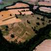
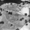
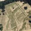
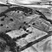
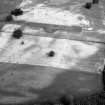
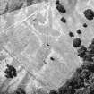
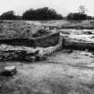
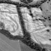
The Legionary Fortress at Inchtuthil, known as Pinnata Castra, was founded by Agricola soon after AD 83 and systematically demolished soon after AD 86.
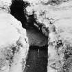
The defences comprise a single ditch, 20' wide by 6 1/2' deep, and a turf rampart, now 13' wide but cut back to receive a stone wall 5' thick. The wall encloses an area of 1,520' by 1,565', or 53 acres. The gateways were of timber,with twin portals recessed between two towers 20' square.
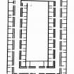
Internal buildings comprise the headquarters, officer's houses, 64 barracks, 6 granaries, stores sheds, military hospital, drill hall and construction shop. Not all the buildings, however, had been built before the fortress was deliberately dismantled, following the transfer of Legio II Adiutrix to the Danube frontier.
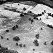
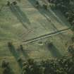
Other visible Roman remains comprise the redoubt and a linear earthwork (the western vallum) W of the fortress is the site of a 'labour camp', almost as large as the fortress, which was occupied during the construction of the latter, and gradually reduced in size as the work progressed. There was yet another temporary camp towards the SW tip of the plateau, and an extra-mural senior officers' temporary compound on the SE angle of the fortress.
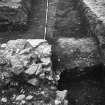
Inchtuthil was excavated by Abercromby in 1901, and by Richmond and St Joseph between 1952 and 1965.
R G Collingwood and I Richmond 1969
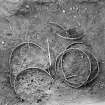
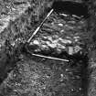
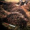
NO 125 397 The late Prof St Joseph discovered an iron ballista head among a small assemblage of nails he had retained from the hoard discovered inside the fabrica. This is the first such item recognised from the hoard. Legally donated to National Museum of Scotland (NMS).
Daybook no: DB 1994/12.
NMS 1994r.
Excavation (1952 - 1965)
Inchtuthil was excavated by Ian A Richmond and Professor J K St Joseph.
Field Visit (2 April 1969)
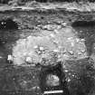
When visited in 1969, the remains of the fortress were as described above, the ditch and rampart being extant either separately or together along most of the S, E, and W sides. The N side, along the edge of a steep natural scarp was less well defined, and was probably greatly affected by erosion, but a mound, defined by a slight scarp (1.0m max height), and extending c. 130.0m, W from the NE angle, probably indicated the N rampart, traces of stone walling being visible on top of the mound at NO 1273 3988.
The redoubt comprised a sub-rectangular enclosure formed by a well-defined 'L'-shaped rampart and ditch backing on to steep natural slopes to the S and E with the possibility of the rampart having formerly continued along the top of the S slopes.
The vallum was an earthwork comprising a rampart and ditch now ploughed out except for a small portion at its N end. The rampart is traceable as a slight swelling in the ploughed field.
Roman finds from Inchtuthil are in Perth Museum, and National Museum of Antiquities of Scotland (NMAS).
Resurveyed at 1/2500.
Visited by OS (WDJ) 2 April 1969.
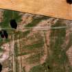
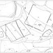
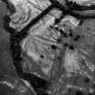
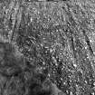
Magnetometry (2009)
NO 1251 3971 A c37ha magnetic survey was undertaken which covered almost the whole of the Roman legionary fortress and significant areas to its E and W. In addition a c16ha resistance survey was conducted of the area surrounding the fortress, and fieldwalking was undertaken in ploughland to the S. The magnetic data showed the basic internal layout of the fortress to be much as shown in Richmond’s plan derived from
trenching in the 1960s, albeit with one large new structure in the NW. However, when seen in full, rather than in narrow test trenches, the buildings proved to be less neatly rectangular. To the E, the surveys revealed a large oval feature just outside the fortress gate and the known barrow field proved to be more extensive than surface and aerial data had shown. To the W, a series of pits might represent a cemetery or settlement, and the resistance work located what may be concentric rectangular features. To the SW, the surveys confirmed aerial indications that an area of dense pitting extends well beyond the confines of the long known temporary camp, right up to the fortress defences. The fieldwalking found Roman finds and copious signs of leadworking in the same area, which may suggest external industrial activity and possibly settlement.
Archive: The Roman Gask Project
Funder: The Roman Research Trust
DJ Woolliscroft, P Morris and B Hoffmann – The Roman Gask Project and Blairgowrie Geoscience
Watching Brief (7 April 2010)
An archaeological watching brief on topsoil stripping and excavation required for a house extension at The Gardens, Delvine, Spittalfield, located within the defensive outworks of the Roman Fortress of Inchtuthil and covering an area of 96m². Along with modern pottery, three sherds of late medieval/post-medieval pottery and three sherds of what were considered to be Roman pottery were recovered from garden deposits. Cuts in the subsoil/natural revealed recent working as part of a garden vegetable plot. A stone floor or surface was found that was tied into the foundation of the house wall and was considered to be a stance for an outside tap. Although some medieval and possibly Roman pottery sherds were found, no discrete features or deposits relating to these periods or any other period, apart from modern, were found.
Alder Archaeology Ltd
Magnetometry (2010)
NO 1251 3971 The work begun in 2009 (DES 2009, 145) was continued. The die-back of undergrowth during the winter made it possible to conduct a magnetic survey of the so called ‘Stores Compound’ or ‘Redoubt’ to the E of the legionary fortress. The presence of trees and bushes still forced gaps in the coverage and made resistance surveying impractical, but a reasonable image was obtained. The defences showed clearly, but no internal structures were detected, apart from slight banding at right angles to the NW ditch, that might represent rig or modern drainage. It is not unusual for a geophysical survey to fail to show internal buildings on turf and timber built sites, but the clarity with which the fortress buildings were revealed by the same instrument, just to the W in 2009, suggests that the absence of evidence here may be significant, especially as it fits well with the small scale trenching done in the compound’s interior during the Richmond excavations, which also located no structures, apart from small gullies. To the SW of the fortress, a further area of the large (19.9ha) temporary camp interior was surveyed. This revealed a good deal of pitting, a clear trace of the so called ‘Vallum’ ditch and an extension of a former carriage drive, connected with Delvine House, which is visible on the surface in the fortress field itself. All of this enhances data already known from the air, and fieldwalking continued to find extensive spreads ofv lead working debris and other finds both inside and outside the camp.
At the SW end of the Inchtuthil plateau, a second enclosure has been seen from the air which has been taken to be a much smaller temporary camp, estimated at only 0.94ha. The camp was surveyed in its entirety, except for a small area at the NE corner, which was planted with a cover crop and inaccessible. It proved to be slightly smaller still at c125 x 70m (0.87ha).
The N, S and W ditches were detected clearly, but no trace of an entrance break was found in any of them. Nor were other camp entrance features, such as tituli, revealed. Moreover, the enclosure appeared to be entirely open to the E, with no sign of either an E ditch, or a turn at the eastern end of the S ditch to form a corner. The site shows poorly from the air (unlike the large camp), but what data has been obtained bears out the impression gained from the survey image. A resistance survey is planned, to make a further search for the E ditch but, on present evidence, there must now be some doubt as to whether this is a Roman camp.
Archive: The Roman Gask Project
Funder: The Roman Research Trust
Earth Resistance Survey (2011)
NO 125 397 The geophysical survey begun in 2009 (DES 2009, 145) of the fortress and its surroundings, continued. It had been intended that the work would concentrate on the area of the temporary camps to the SW of the main fortress area, but the late harvest caused by an unusually poor summer delayed things considerably. Instead, large scale resistance work was continued inside the fortress, and some of the principal internal buildings which had already been covered magnetically, were re-scanned at higher resolution (0.5 x 0.125m). This produced superb detail, in places showing features that had not been detected by the Richmond excavations. The best image was produced by the hospital building, and its surrounding barracks, where individual posts could be seen, but the principia and fabrica also produced excellent data (for example a passage between rooms in the NE wing of the latter). Outside the fortress, a large oval feature detected near the NE gate in 2009 had caused speculation that it might represent an amphitheatre. The higher resolution data refuted this, however, by showing the feature to be caused by two different features that had previously appeared conflated.
Some work was also possible in the arable fields further W. Magnetic work in 2010 (DES 2010, 137) had cast doubt on the identification of a rectangular enclosure, towards the SW end of the plateau, as a small Roman temporary camp because only three sides could be detected and no entrance breaks were found in the remaining sides. Aerial coverage had produced the same picture, and in 2011 so did a resistance survey. As resistance can often locate ditches missed by other remote sensing techniques, this seems to be a further indication that the feature is unlikely to be a completed Roman camp.
Continued survey of the large temporary camp, nearer the fortress, confirmed the indications gained in past seasons of an even denser pattern of internal (and indeed external) pits than that seen in air photographs. Finally, coverage of the so called 'officers' compound' further E revealed what is likely to be a third barrack to the S of the two already known from excavation.
Archive: The Roman Gask Project
Funder: Perth and Kinross Heritage Trust
The Roman Gask Project, 2011

