
Pricing Change
New pricing for orders of material from this site will come into place shortly. Charges for supply of digital images, digitisation on demand, prints and licensing will be altered.
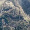
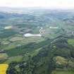
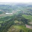
Moncreiffe Hill


Fort (Period Unassigned), Arrowhead (Neolithic)
Site Name Moncreiffe Hill
Classification Fort (Period Unassigned), Arrowhead (Neolithic)
Canmore ID 28058
Site Number NO11NW 7
NGR NO 1313 1988
Datum OSGB36 - NGR
Permalink http://canmore.org.uk/site/28058


- Council Perth And Kinross
- Parish Dunbarney
- Former Region Tayside
- Former District Perth And Kinross
- Former County Perthshire
Field Visit (11 June 1964)
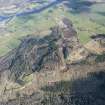
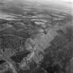
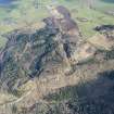
The slight remains of this fort are situated on a craggy height with a cliff on the south and steep slopes on the other sides.
On the SE side are traces of a rampart 1.0m high externally and not exceeding 0.3m internally which may have continued to the NE to form an annexe, but could not be traces further due to Forestry Commission planting.
On the NE are slight indications of stony construction but elsewhere only a faint suggestion of scarping marks the possible course.
There is an entrance from the SE and a possible entrance from the W. Resurveyed at 1/2500.
Visited by OS (R D L) 11 June 1964.
Desk Based Assessment (23 June 1965)
NO11NW 7 1313 1988.
(NO 1313 1988) Fort (NR)
OS 6" map, (1959)
The plateau is bounded by the remains of a wall, in places a foot high, forming an irregular circle, from which the gound falls away very rapidly. There does not appear to have been a ditch. Christison could only find a mass of rough masonry in a chance break in the ground.
Information from OS (DJC) 23 June 1965.
Sources: Name Book 1860; D Christison 1900.
Field Visit (September 1996)
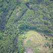
All traces of previous Forestry Commission plantings have been removed from the area of this fort, but it is so poorly preserved that no further details can be added to the existing OS plan and description.
Visited by RCAHMS (JRS), September 1996.
Project (19 April 2013 - 23 April 2013)
NO 1313 1988 Resistivity and magnetic surveys were carried out, 19–23 April 2013, over the central area of the hillfort. This is not a good area for magnetics as the bedrock is a lava flow which outcrops at the S edge of the fort. The grey scale display of the magnetic survey has a rather granular texture with no obvious archaeology, and it seems likely that most of the anomalies have a geological origin. The resistivity work hints at two circular features 10–15m in diameter. Taking a positive view, these could be enclosures or habitation features, being more negative, they are related to the forestry which formerly covered the site.
Archive: RCAHMS and Perth and Kinross HER (intended)
Funder: Perth and Kinross Heritage Trust
Peter Morris, Blairgowrie Geoscience, 2013
(Source: DES)
Magnetometry (19 April 2013 - 23 April 2013)
NO 1313 1988 Magnetometry survey
Archive: RCAHMS and Perth and Kinross HER (intended)
Funder: Perth and Kinross Heritage Trust
Peter Morris, Blairgowrie Geoscience, 2013
(Source: DES)
Earth Resistance Survey (19 April 2013 - 23 April 2013)
NO 1313 1988 Resistivity survey
Archive: RCAHMS and Perth and Kinross HER (intended)
Funder: Perth and Kinross Heritage Trust
Peter Morris, Blairgowrie Geoscience, 2013
(Source: DES)
Archaeological Evaluation (1 September 2014 - 6 September 2014)
NO 1313 1988 Phase 1 of a programme of archaeological work was undertaken, 1–6 September 2014, at Moncreiffe Hillfort by Tay Landscape Partnership, led by Perth and Kinross Heritage Trust, and delivered by AOC Archaeology Group and local volunteers.
The evaluation consisted of the excavation of three trenches located over the potential ramparts of the hillfort and a laser scan survey of the monument. The laser scan produced a detailed topographic map of the hillfort, which demonstrated that the upstanding earthworks of the hillfort consisted of the slight remains of a single rampart along with two possible entrances, one to the E and one to the W.
The three excavation trenches provided evidence of the structure and use of the hillfort. These structural remains comprised a rampart with an earth core and dry stone facing, recorded in two of the trenches, along with a hut platform constructed on top of the slumped remains of the rampart in one trench. No rampart was identified in the third trench, but a bedrock-cut ditch was exposed that may relate to activity in the hillfort. An artefact assemblage relating to the use of the hillfort was recovered, including a fragment of a shale bracelet and a possible stone gaming piece.
Archive: National Record of the Historic Environment (NRHE) intended
Funder: Tay Landscape Partnership
Jamie Humble and Sophie Nicol - AOC Archaeology Group
Source: DES, Volume 16
Excavation (21 April 2015 - 2 May 2015)
NO 1313 1988 An excavation was undertaken, 21 April – 2 May 2015, at Moncreiffe Hillfort by the Tay Landscape Partnership, with local volunteers, Perth and Kinross Heritage Trust and AOC Archaeology Group. The 2015 work followed on from a topographic survey and the excavation of three
trenches in 2014 (DES 16, 140).
The excavation consisted of four trenches located over the potential ramparts and within the interior of the hillfort. A series of three earthen ramparts was identified in a 2 x 12m trench excavated over the western circuit of the hillfort enclosure, taken with previous years’ excavations
there would appear to be at least four concentric ramparts at parts of the hillfort, although it is not clear whether these are contemporary or reflect multiple phases of construction.
A 2 x 10.5m trench excavated over the eastern circuit of the hillfort enclosure revealed a stone-faced rampart, along with a series of cut bedrock terraces. A 7 x 6m trench excavated over the entrance in the W of the hillfort revealed the entrance, which was defined by a cut bedrock terrace to the interior of the hillfort and a stone bank forming the outer edge of the entrance. A fourth trench excavated over a scoop, putatively identified as a house platform within the interior of the hillfort, revealed this feature to be of natural origin.
An artefact assemblage relating to the use of the hillfort was recovered including a significant ceramic assemblage, an unusual heavy-duty stone maul, and a stone (possibly jet) bead. Struck stone artefacts, predating the construction of the hillfort, were also recovered, notably a leaf shaped
arrowhead of Neolithic date.
Archive: NRHE
Funder: Tay Landscape Partnership
Martin Cook - AOC Archaeology Group
(Source: DES, Volume 17)
Note (6 May 2015 - 18 May 2016)
The remains of a fort are situated on a local summit along the ridge of Moncrieffe Hill. Its defences comprise a heavily degraded rampart reduced to little more than a scarp which can be traced round the margins of the summit on the E, N and W. A line of facing stones is visible on the NW, where excavation in 2014 revealed a mass of tumbled stones on the slope below; further excavations in 2015 are being carried out to discover whether there are also outer defences lower down this slope below. A second trench through the rampart in 2014 showed that its core on the ENE was substantially of turf, while the extension of the trench down the slope in 2015 has revealed traces of what may be cut steps in the bedrock. The interior, which is featureless, is irregular on plan, measuring about 70m from ENE to WSW by 50m transversely (0.27ha), and there are entrances on the W and E. Fugitive traces of occupation were revealed by an evaluation trench in the interior, and finds to date include pottery, a fragment of shale bracelet, a few coarse stone tools and a possible gaming piece.
Information from An Atlas of Hillforts of Great Britain and Ireland – 18 May 2016. Atlas of Hillforts SC3033

