
Glen Cochill


Field System (Prehistoric) - (Post Medieval), Hut Circle(S) (Prehistoric), Pitcarmick Building(S) (Early Medieval), Shieling Hut(S) (Post Medieval)
Site Name Glen Cochill
Classification Field System (Prehistoric) - (Post Medieval), Hut Circle(S) (Prehistoric), Pitcarmick Building(S) (Early Medieval), Shieling Hut(S) (Post Medieval)
Canmore ID 26252
Site Number NN94SW 1
NGR NN 90732 41196
NGR Description centred on NN 905 410
Datum OSGB36 - NGR
Permalink http://canmore.org.uk/site/26252


- Council Perth And Kinross
- Parish Little Dunkeld
- Former Region Tayside
- Former District Perth And Kinross
- Former County Perthshire
NN94SW 1 centred on 905 410.
A cairnfield in association with a large ring- cairn was found close to the main road between Amulree and Aberfeldy; 300 yds N from the point where Wade's road crosses the main road and 100 yds W of it, lies the ring cairn, 42' overall, capping a small knoll. The remains of a crude boulder wall runs for 100' E from it. SE of this ring cairn, at 60', lies another, 21' overall. South again is a small cairnfield of some dozen cairns of the 15' variety. A short distance SW of it, and over a small stream lies another small cairnfield. Scott-Elliot centres the site at NN 903 411, but the direction take it to NN 906 406.
J Scott-Elliot 1964
Scott-Elliot is undoubtedly referring to six hut circles (A - F) and associated field systems centred on NN 905 412. There appear to be no ring cairns.
Hut 'A', near the top of a low knoll and overlaid by a later field bank, survives as a low, spread, heather-covered bank, c. 2.2m wide and 9.0m in diameter. A lowering in the NE quadrant suggests an entrance at that point.
'B', on the top of a knoll, measures c. 8.0m in diameter within a low earth-and-stone wall c. 0.9m thick, in which facing stones are visible intermittently. A 1.3m wide gap in the S is almost certainly the entrance. To the N, extending down the top of a slight ridge and contiguous with the edge of the hut, is the outline of a rectangular structure c. 12.0m N-S x 3.0m within walls visible as a low stony bank. A low cross wall bisects the interior, but no entrance is visible.
About 14.0m NNW of the hut is a possible contemporary circular enclosure measuring c. 5.0m in diameter. There is no entrance evident.
'C', near the top of a low knoll, measures 12.5m in diameter within substantial stone walls with inner and outer facing stones giving an average width of 1.7m, apart from on the E where the wall has been robbed for an adjoining field wall. The entrance was probably in the SW where there is a slight lowering of the ground. Immediately to the E is a rectangular building measuring 4.5m x 2.2m, with traces of a crude wall at its W end.
'D', situated on a low knoll, survives as a 2.0m spread earth-and-stone bank in which an outer wall face is visible, giving an overall diameter of 15.0m. A slight lowering in the SSW suggests the position of the entrance.
'E', poorly preserved and set slightly into an E-facing slope, is visible as a low spread earth-and- stone bank c. 2.5m wide, 7.5m in diameter between its centres. The entrance, c. 1.0m wide, is in the S. 'F', situated on a slight terrace, survives as a low, mutilated, earth-and-stone bank spread to 2.5m, 9.8m in diameter between centres. Although no definite faces are visible, there are a few large stones around the perimeter. There are two breaks in the bank in the SSE and SW, and it is difficult to ascertain which is the original entrance.
In the vicinity of all the huts there are traces of old field walls and clearance heaps, some probably contemporary with the huts while others are undoubtedly later. There are no definite field plots.
Surveyed at 1:10,000.
Visited by OS (RD) 20 November 1970
There are two further hut circles, 'G' and 'H'. 'G' measures c. 11.0m in diameter between centres of a heather-covered wall. Entrance in SE. 'H' measures c. 9.5m in diameter between centres of in ill-preserved wall. Entrance in S.
Surveyed at 1:10,000.
Visited by OS (JM) 19 February 1975
Field Visit (20 November 1970)
Scott-Elliot is undoubtedly referring to six hut circles (A - F) and associated field systems centred on NN 905 412. There appear to be no ring cairns.
Hut 'A', near the top of a low knoll and overlaid by a later field bank, survives as a low, spread, heather-covered bank, c. 2.2m wide and 9.0m in diameter. A lowering in the NE quadrant suggests an entrance at that point.
'B', on the top of a knoll, measures c. 8.0m in diameter within a low earth-and-stone wall c. 0.9m thick, in which facing stones are visible intermittently. A 1.3m wide gap in the S is almost certainly the entrance. To the N, extending down the top of a slight ridge and contiguous with the edge of the hut, is the outline of a rectangular structure c. 12.0m N-S x 3.0m within walls visible as a low stony bank. A low cross wall bisects the interior, but no entrance is visible.
About 14.0m NNW of the hut is a possible contemporary circular enclosure measuring c. 5.0m in diameter. There is no entrance evident.
'C', near the top of a low knoll, measures 12.5m in diameter within substantial stone walls with inner and outer facing stones giving an average width of 1.7m, apart from on the E where the wall has been robbed for an adjoining field wall. The entrance was probably in the SW where there is a slight lowering of the ground. Immediately to the E is a rectangular building measuring 4.5m x 2.2m, with traces of a crude wall at its W end.
'D', situated on a low knoll, survives as a 2.0m spread earth-and-stone bank in which an outer wall face is visible, giving an overall diameter of 15.0m. A slight lowering in the SSW suggests the position of the entrance.
'E', poorly preserved and set slightly into an E-facing slope, is visible as a low spread earth-and- stone bank c. 2.5m wide, 7.5m in diameter between its centres. The entrance, c. 1.0m wide, is in the S. 'F', situated on a slight terrace, survives as a low, mutilated, earth-and-stone bank spread to 2.5m, 9.8m in diameter between centres. Although no definite faces are visible, there are a few large stones around the perimeter. There are two breaks in the bank in the SSE and SW, and it is difficult to ascertain which is the original entrance.
In the vicinity of all the huts there are traces of old field walls and clearance heaps, some probably contemporary with the huts while others are undoubtedly later. There are no definite field plots.
Surveyed at 1:10,000.
Visited by OS (RD) 20 November 1970
Field Visit (19 February 1975)
There are two further hut circles, 'G' and 'H'. 'G' measures c. 11.0m in diameter between centres of a heather-covered wall. Entrance in SE. 'H' measures c. 9.5m in diameter between centres of in ill-preserved wall. Entrance in S.
Surveyed at 1:10,000.
Visited by OS (JM) 19 February 1975
Field Visit (October 1993)
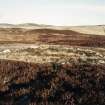
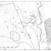
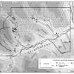
There are extensive settlement remains across the floor of Glen Cochill to the W of the present A826 Amulree-Aberfeldy road and about 1.5km S of Scotston farmsteading. In an area measuring approximately 700m NE-SW by up to 600m transversely there are ten hut-circles, four long buildings of Pitcarmick type, six huts and other small buildings, a small patch of rig cultivation, groups of small cairns and numerous fragments of bank, some of which define large enclosures and fields. Also within this area there is a burial cairn, the 'White Cairn' (NN94SW 2), and, situated on rising ground to the SW, there are other agricultural remains (NN 94SW 4).
The hut-circles are widely spaced across the area, half of them sited on the tops of small knolls, most of the others located on slight terraces where the ground starts to rise towards the W. There were ten recorded during the survey, eight of which had already been noted by the OS (Braan93 79, OS hut A; Braan93 83, OS hut B; Braan93 84; Braan93 92-5, OS huts C, H, E and F; Braan93 120, OS hut G; Braan93 123, OS hut D; and Braan93 125). The majority of them measure between 7m and 8m in diameter within walls reduced to spread stony banks up to 1.8m in thickness, in which only occasional inner and outer facing-stones are visible. Four huts fall outside this size range: one is smaller (Braan93 94; NN 9029 4108), measuring 5m in internal diameter; the other three are larger, with internal diameters of 9.5m (Braan93 120; NN 9032 4148), 10.5m (Braan93 123, NN 9044 4093) and 12.7m (Braan93 92, NN 9065 4126). Where entrances are visible they almost all fall in the arc between SW and SE, the only exception (Braan93 79, NN 9072 4134) appears to have been entered from the NNE. Around the huts there are numerous small cairns and lengths of bank, at least some of which are probably contemporary with them, although in the two cases where a relationship is clearly visible the banks overlie the hut-circles (Braan93 79 and 92).
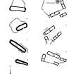
Out of the ten buildings and huts recorded in this area four stand out as being particularly large and are of Pitcarmick type (Braan93 77, NN 9076 4119; Braan93 78, NN 9078 4129; Braan93 80, NN 9067 4133; Braan93 124, NN 9047 4093). The first two of these measure respectively 33.8m in length by 7.1m in breadth and 32.3m in length by 7.8m in breadth over walls reduced to stony banks about 2m thick, while a third (Braan93 124) measures 17.2m in length by 7.5m in breadth over a stony bank 1.9m thick. These three buildings all have rounded ends and slightly bowed sides. One (Braan93 77) is divided into three compartments, the central compartment having an elongated depression 0.4m deep, which may indicate a drain. Internal divisions are less clear in the other two buildings, although there is a drop in ground level across the centre of Braan93 124, the narrower SSE end being lower, while the interior of Braan93 78 slopes down towards its narrow ESE end. The fourth building (Braan93 80) appears to be of slightly different construction, measuring 26.7m in length by 7.2m in breadth over faced rubble walls 1m thick with squared corners, although these differences may be due in part to better preservation, for the similarities it has with the others - its bowed ENE side wall and above all the huge scale of the building - mark it as a member of this group. A stony bank runs the length of this building, outside its ENE side wall and parallel to it. The purpose of this is not entirely clear but as the ground rises slightly on this side it may be connected with drainage. Similar banks flank part of two of the other buildings (Braan93 77-8). The proximity to a group of hut-circles is characteristic of Pitcarmick-type buildings, but only in one instance can a relationship between one of these buildings and the hut-circles be suggested here: towards the NE edge of the site a Pitcarmick-type building (Braan93 80) appears to form an integral part of a group of enclosures or small fields, the banks of which overlie two hut-circles (Braan93 79 and 92).
There are two other buildings and four subrectangular or oval huts in this area. The buildings measure 9.8m in length by 3.3m in breadth within faced rubble walls 1m thick (Braan93 85) and 9.2m in length by 3.2m in breadth within walls spread to a thickness of 0.9m (Braan93 90). They are both divided into two compartments, and one (Braan93 90) is bow-sided with rounded ends. The huts, three of which are located on top of small knolls, measure between 2.6m and 5.6m in length and between 2m and 3.8m in breadth within walls measuring between 0.7m and 0.9m where original thicknesses can be gauged (Braan93 86, 89, 91, 119). One hut (Braan93 119, NN 9037 4135) is overlain by the bank flanking the E side of the military road, while another hut, and also one of the buildings (Braan93 90-1) overlie a bank defining one of the enclosures which may be associated with the Pitcarmick-type buildings.
Around the structures described above there are over one hundred small cairns, numerous stretches of bank and a small area of rig-and-furrow, all falling within an area of about 20ha. The heather-covered cairns measure up to about 4m in diameter and tend to be grouped in small clusters, particularly where the ground is drier and more even. Some are clustered along the route of the military road and may consist of debris from its construction and maintenance, but others, such as the group at NN 907 414 (Braan93 82) are more likely to indicate prehistoric clearance. In the SW half of the area only short disjointed stretches of bank are visible, occasionally linking natural features to suggest small fields. To the NE, though, a more organised, well-defined group of enclosures or fields survives, covering about 4ha. It has been noted above that the banks enclosing these fields overlie two of the hut-circles, and it may be that they are contemporary with the Pitcarmick buildings, as one of the latter, (Braan93 80), seems to form part of the SW side of one of the buildings. There are further areas of cultivation remains immediately to the SW, described under NN 94SW 4.
(Braan93 77-87, 89-95, 119-125)
Visited by RCAHMS (SDB, PJD) October 1993
Field Visit (October 1993)
There are extensive settlement remains across the floor of Glen Cochill to the W of the present A826 Amulree-Aberfeldy road and about 1.5km S of Scotston farmsteading. In an area measuring approximately 700m NE-SW by up to 600m transversely there are ten hut-circles, four long buildings of Pitcarmick type, six huts and other small buildings, a small patch of rig cultivation, groups of small cairns and numerous fragments of bank, some of which define large enclosures and fields. Also within this area there is a burial cairn, the 'White Cairn' (NN94SW 2), and, situated on rising ground to the SW, there are other agricultural remains (NN 94SW 4).
The hut-circles are widely spaced across the area, half of them sited on the tops of small knolls, most of the others located on slight terraces where the ground starts to rise towards the W. There were ten recorded during the survey, eight of which had already been noted by the OS (Braan93 79, OS hut A; Braan93 83, OS hut B; Braan93 84; Braan93 92-5, OS huts C, H, E and F; Braan93 120, OS hut G; Braan93 123, OS hut D; and Braan93 125). The majority of them measure between 7m and 8m in diameter within walls reduced to spread stony banks up to 1.8m in thickness, in which only occasional inner and outer facing-stones are visible. Four huts fall outside this size range: one is smaller (Braan93 94; NN 9029 4108), measuring 5m in internal diameter; the other three are larger, with internal diameters of 9.5m (Braan93 120; NN 9032 4148), 10.5m (Braan93 123, NN 9044 4093) and 12.7m (Braan93 92, NN 9065 4126). Where entrances are visible they almost all fall in the arc between SW and SE, the only exception (Braan93 79, NN 9072 4134) appears to have been entered from the NNE. Around the huts there are numerous small cairns and lengths of bank, at least some of which are probably contemporary with them, although in the two cases where a relationship is clearly visible the banks overlie the hut-circles (Braan93 79 and 92).
Out of the ten buildings and huts recorded in this area four stand out as being particularly large and are of Pitcarmick type (Braan93 77, NN 9076 4119; Braan93 78, NN 9078 4129; Braan93 80, NN 9067 4133; Braan93 124, NN 9047 4093). The first two of these measure respectively 33.8m in length by 7.1m in breadth and 32.3m in length by 7.8m in breadth over walls reduced to stony banks about 2m thick, while a third (Braan93 124) measures 17.2m in length by 7.5m in breadth over a stony bank 1.9m thick. These three buildings all have rounded ends and slightly bowed sides. One (Braan93 77) is divided into three compartments, the central compartment having an elongated depression 0.4m deep, which may indicate a drain. Internal divisions are less clear in the other two buildings, although there is a drop in ground level across the centre of Braan93 124, the narrower SSE end being lower, while the interior of Braan93 78 slopes down towards its narrow ESE end. The fourth building (Braan93 80) appears to be of slightly different construction, measuring 26.7m in length by 7.2m in breadth over faced rubble walls 1m thick with squared corners, although these differences may be due in part to better preservation, for the similarities it has with the others - its bowed ENE side wall and above all the huge scale of the building - mark it as a member of this group. A stony bank runs the length of this building, outside its ENE side wall and parallel to it. The purpose of this is not entirely clear but as the ground rises slightly on this side it may be connected with drainage. Similar banks flank part of two of the other buildings (Braan93 77-8). The proximity to a group of hut-circles is characteristic of Pitcarmick-type buildings, but only in one instance can a relationship between one of these buildings and the hut-circles be suggested here: towards the NE edge of the site a Pitcarmick-type building (Braan93 80) appears to form an integral part of a group of enclosures or small fields, the banks of which overlie two hut-circles (Braan93 79 and 92).
There are two other buildings and four subrectangular or oval huts in this area. The buildings measure 9.8m in length by 3.3m in breadth within faced rubble walls 1m thick (Braan93 85) and 9.2m in length by 3.2m in breadth within walls spread to a thickness of 0.9m (Braan93 90). They are both divided into two compartments, and one (Braan93 90) is bow-sided with rounded ends. The huts, three of which are located on top of small knolls, measure between 2.6m and 5.6m in length and between 2m and 3.8m in breadth within walls measuring between 0.7m and 0.9m where original thicknesses can be gauged (Braan93 86, 89, 91, 119). One hut (Braan93 119, NN 9037 4135) is overlain by the bank flanking the E side of the military road, while another hut, and also one of the buildings (Braan93 90-1) overlie a bank defining one of the enclosures which may be associated with the Pitcarmick-type buildings.
Around the structures described above there are over one hundred small cairns, numerous stretches of bank and a small area of rig-and-furrow, all falling within an area of about 20ha. The heather-covered cairns measure up to about 4m in diameter and tend to be grouped in small clusters, particularly where the ground is drier and more even. Some are clustered along the route of the military road and may consist of debris from its construction and maintenance, but others, such as the group at NN 907 414 (Braan93 82) are more likely to indicate prehistoric clearance. In the SW half of the area only short disjointed stretches of bank are visible, occasionally linking natural features to suggest small fields. To the NE, though, a more organised, well-defined group of enclosures or fields survives, covering about 4ha. It has been noted above that the banks enclosing these fields overlie two of the hut-circles, and it may be that they are contemporary with the Pitcarmick buildings, as one of the latter, (Braan93 80), seems to form part of the SW side of one of the buildings. There are further areas of cultivation remains immediately to the SW, described under NN 94SW 4.
(Braan93 77-87, 89-95, 119-125)
Visited by RCAHMS (SDB, PJD) October 1993

