
Scheduled Maintenance
Please be advised that this website will undergo scheduled maintenance on the following dates: •
Tuesday 3rd December 11:00-15:00
During these times, some services may be temporarily unavailable. We apologise for any inconvenience this may cause.
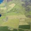
Rousay, Wasbister, Cogar


Barrow (Bronze Age)(Possible), Burial Cairn (Bronze Age)(Possible)
Site Name Rousay, Wasbister, Cogar
Classification Barrow (Bronze Age)(Possible), Burial Cairn (Bronze Age)(Possible)
Canmore ID 2308
Site Number HY33SE 4
NGR HY 39433 32722
Datum OSGB36 - NGR
Permalink http://canmore.org.uk/site/2308


- Council Orkney Islands
- Parish Rousay And Egilsay
- Former Region Orkney Islands Area
- Former District Orkney
- Former County Orkney
HY33SE 4 3943 3273.
There is a mound of burnt stones about 250 yds S of Cogar.
RCAHMS 1946. Visited 1933.
HY 3943 3273. A circular turf-covered mound of stones measuring 8.5m in diameter and 0.7m high with a hollowed top. There is no trace of burnt material and no local knowledge of any ever being found, and it seems likely that this is a cairn and not a burnt mound.
Surveyed at 1:2500.
Visited by OS (AA) 12 October 1972.
Field Visit (12 October 1972)
HY 3943 3273. A circular turf-covered mound of stones measuring 8.5m in diameter and 0.7m high with a hollowed top. There is no trace of burnt material and no local knowledge of any ever being found, and it seems likely that this is a cairn and not a burnt mound.
Surveyed at 1:2500.
Visited by OS (AA) 12 October 1972.
Field Visit (September 1980)
Neatly circular mound with sharp profile. Appearance and
position strongly suggests a burial mound.
Information from Orkney SMR (RGL) Sep 80.
Field Visit (September 1980)
Wasbister HY 3942 3273 HY33SE 4
Neatly circular mound with sharp profile, measuring 8.5m in diameter and 0. 7m in height; no burnt stones visible, and appearance suggests a burial-mound.
RCAHMS 1982, visited September 1980
(RCAHMS 1946, ii, p. 226, No. 590; 0 R 518)
Field Visit (25 April 1994)
A field visit during the course of the Orkney Barrows project recorded a bowl-shaped mound, with a diameter of 8.9m by 8.0m and a height of 0.6m. It is visible for a distance of 1km from all directions.
Information from Orkney Barrows Project, 1994
Field Visit (7 May 2013)
Formerly identified as a burnt mound (RCAHMS 1946, No. 590), this cairn is situated on a terrace within a small patch of ground that has escaped rigorous improvement. As recorded by the Ordnance Survey, it measures 8.5m in diameter and 0.7m in height, and the ‘hollowed top’ they describe is likely to be the result of an excavation. A shallower depression on the NE, which is accompanied by a small pile of spoil, appears to be of more recent date.
Visited by RCAHMS (GFG) 7 May 2013.

