Scheduled Maintenance
Please be advised that this website will undergo scheduled maintenance on the following dates: •
Tuesday 3rd December 11:00-15:00
During these times, some services may be temporarily unavailable. We apologise for any inconvenience this may cause.
RCAHMS Special Survey, Orkney


Date 6 May 2013 - 10 May 2013
Event ID 960982
Category Project
Type Project
Permalink http://canmore.org.uk/event/960982
Two RCAHMS staff joined Historic Scotland for 1 week of their visit to Orkney to revise Scheduling documentation (DES 2013, 200). The RCAHMS staff created 16 new site descriptions and captured 61 record photographs.
Information from RCAHMS (GFG, ATW), May 2013.

| Event | Type | Subtype | Notes | Date |
|---|---|---|---|---|
| 963755 | DESCRIPTIVE ACCOUNTS | CANCELLATION | Record cancelled, see HY33SE 44. | 29 August 2013 |
| 963578 | RECORDING | FIELD VISIT | This dyke, known as Green Gairsty (RCAHMS 1982, No.91), is situated on the steep north flank of Kierfea Hill, some 680m ESE of Langskaill farmsteading. It comprises an earthen bank orientated roughly N and S and measuring about 10m in thickness by up to 0.8m in height. The N end of the dyke appears to terminate immediately before the cliff edge while the S end runs into a natural break of slope below a the 19th century stone wall and road. There is no evidence that the dyke is broken by the road (contra RCAHMS 1982, 8) or that it continued beyond it. [...] | 7 May 2013 |
| 963742 | RECORDING | FIELD VISIT | A scatter of up to six grass-grown barrows are visible in two pasture fields about 170m NNW of the ruins of Appiehouse farmstead. [...] | 10 May 2013 |

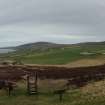
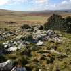
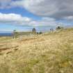
DP 153255
Panorama from entrance.
RCAHMS Field Survey Digital Photography
5/2013
© Crown Copyright: HES

DP 153256
General view.
RCAHMS Field Survey Digital Photography
5/2013
© Crown Copyright: HES

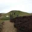
DP 153257
Panorama with cairn in foreground.
RCAHMS Field Survey Digital Photography
5/2013
© Crown Copyright: HES

DP 153258
General shot.
RCAHMS Field Survey Digital Photography
5/2013
© Crown Copyright: HES

DP 153259
General shot from the north.
RCAHMS Field Survey Digital Photography
7/5/2013
© Crown Copyright: HES

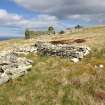
DP 153260
General shot of passage and chamber (excavated).
RCAHMS Field Survey Digital Photography
7/5/2013
© Crown Copyright: HES

DP 153261
Panorma with cairn at centre.
RCAHMS Field Survey Digital Photography
7/5/2013
© Crown Copyright: HES

DP 153262
General shot from the S: Green Gairsty treb dyke.
RCAHMS Field Survey Digital Photography
7/5/2013
© Crown Copyright: HES

DP 153263
General shot.
RCAHMS Field Survey Digital Photography
7/5/2013
© Crown Copyright: HES

DP 153264
General shot.
RCAHMS Field Survey Digital Photography
5/2013
© Crown Copyright: HES

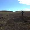
DP 153265
General shot of the Knowe of Hammar burnt mound, taken from the south west.
RCAHMS Field Survey Digital Photography
7/5/2013
© Crown Copyright: HES

DP 153266
General shot
RCAHMS Field Survey Digital Photography
7/5/2013
© Crown Copyright: HES

DP 153267
Panorama centred on barrow and SE.
RCAHMS Field Survey Digital Photography
7/5/2013
© Crown Copyright: HES

DP 153268
General shot of the remains of the two tumuli, one marked with the scale.
RCAHMS Field Survey Digital Photography
8/5/2013
© Crown Copyright: HES

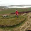
DP 153269
General shot of the Brough of Bigging.
RCAHMS Field Survey Digital Photography
8/5/2013
© Crown Copyright: HES

DP 153270
View of outer rampart at the Brough of Bigging.
RCAHMS Field Survey Digital Photography
8/5/2013
© Crown Copyright: HES

DP 153271
View of outer rampart at the Brough of Bigging.
RCAHMS Field Survey Digital Photography
8/5/2013
© Crown Copyright: HES

DP 153272
View of inner rampart and structure: Brough of Bigging.
RCAHMS Field Survey Digital Photography
8/5/2013
© Crown Copyright: HES

DP 153273
View of modern cairn and enclosure.
RCAHMS Field Survey Digital Photography
8/5/2013
© Crown Copyright: HES

DP 153274
View of eroding feature, possibly a cairn.
RCAHMS Field Survey Digital Photography
8/5/2013
© Crown Copyright: HES

DP 153275
View of eroding feature, possibly a cairn.
RCAHMS Field Survey Digital Photography
8/5/2013
© Crown Copyright: HES

DP 153276
General view looking towards the inner rampart and adjacent structure.
RCAHMS Field Survey Digital Photography
8/5/2013
© Crown Copyright: HES

DP 153277
General shot of structure by inner rampart.
RCAHMS Field Survey Digital Photography
8/5/2013
© Crown Copyright: HES

DP 153278
General shot of burnt mound.
RCAHMS Field Survey Digital Photography
8/5/2013
© Crown Copyright: HES

DP 153279
General shot of northern burnt mound and adjacent building.
RCAHMS Field Survey Digital Photography
8/5/2013
© Crown Copyright: HES

DP 153280
General shot of northern burnt mound and adjacent building.
RCAHMS Field Survey Digital Photography
8/5/2013
© Crown Copyright: HES

DP 153281
General shot of the most well-preserved barrow.
RCAHMS Field Survey Digital Photography
8/5/2013
© Crown Copyright: HES

DP 153282
General shot of another barrow.
RCAHMS Field Survey Digital Photography
8/5/2013
© Crown Copyright: HES

DP 153283
General shot of burnt mound.
RCAHMS Field Survey Digital Photography
9/5/2013
© Crown Copyright: HES

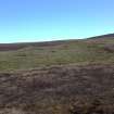
DP 153284
General shot.
RCAHMS Field Survey Digital Photography
9/5/2013
© Crown Copyright: HES

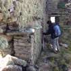
DP 153285
General shot of internal window.
RCAHMS Field Survey Digital Photography
9/5/2013
© Crown Copyright: HES

DP 153286
Main building, SE elevation.
RCAHMS Field Survey Digital Photography
9/5/2013
© Crown Copyright: HES

DP 153287
General shot of ancillary buildings.
RCAHMS Field Survey Digital Photography
9/5/2013
© Crown Copyright: HES

DP 153288
General shot.
RCAHMS Field Survey Digital Photography
5/2013
© Crown Copyright: HES

DP 153289
General shot of NE building, with kiln at NE end.
RCAHMS Field Survey Digital Photography
9/5/2013
© Crown Copyright: HES

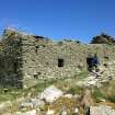
DP 153290
Main building at Tafts, Rousay, SW gable.
RCAHMS Field Survey Digital Photography
9/5/2013
© Crown Copyright: HES

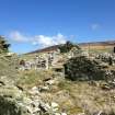
DP 153291
General shot of Tafts, Rousay, from the S.
RCAHMS Field Survey Digital Photography
9/5/2013
© Crown Copyright: HES

DP 153292
General shot of Tafts, Rousay, from the SE.
RCAHMS Field Survey Digital Photography
9/5/2013
© Crown Copyright: HES

DP 153293
General shot of Tafts, Rousay, with outbuilding in foreground.
RCAHMS Field Survey Digital Photography
9/5/2013
© Crown Copyright: HES

DP 153294
General shot of the farmstead at Breck, Quendal, from the E.
RCAHMS Field Survey Digital Photography
9/5/2013
© Crown Copyright: HES

DP 153295
View of bed alcove at Breck, Quendal.
RCAHMS Field Survey Digital Photography
9/5/2013
© Crown Copyright: HES

DP 153296
General shot of storage niches at Breck, Quendal.
RCAHMS Field Survey Digital Photography
9/5/2013
© Crown Copyright: HES

DP 153297
General shot of the kiln-barn at Breck, Quendal.
RCAHMS Field Survey Digital Photography
9/5/2013
© Crown Copyright: HES

DP 153298
General shot of the house at Breck, Quendal.
RCAHMS Field Survey Digital Photography
9/5/2013
© Crown Copyright: HES

DP 153299
Detail of the kiln-barn at Breck, Quendal, showing winnowing opening and kiln.
RCAHMS Field Survey Digital Photography
9/5/2013
© Crown Copyright: HES

DP 153300
General shot of outbuilding S of Breek.
RCAHMS Field Survey Digital Photography
9/5/2013
© Crown Copyright: HES

DP 153301
General shot of the farmstead at Breek, Quendal.
RCAHMS Field Survey Digital Photography
9/5/2013
© Crown Copyright: HES

DP 153302
General shot of new burnt being surveyed, with Knowe of Dale behind.
RCAHMS Field Survey Digital Photography
9/5/2013
© Crown Copyright: HES

DP 153303
General shot of the Knowe of Dale, Rousay.
RCAHMS Field Survey Digital Photography
9/5/2013
© Crown Copyright: HES

DP 153304
General shot of barrow (partially excavated).
RCAHMS Field Survey Digital Photography
9/5/2013
© Crown Copyright: HES

DP 153305
General shot of two barrows, one marked by the staff, the other by Mr J Bruhn.
RCAHMS Field Survey Digital Photography
9/5/2013
© Crown Copyright: HES

DP 153306
General shot of excavated barrow.
RCAHMS Field Survey Digital Photography
9/5/2013
© Crown Copyright: HES

DP 153307
General shot of excavated barrow.
RCAHMS Field Survey Digital Photography
9/5/2013
© Crown Copyright: HES

DP 153308
General shot of grass-grown farmstead at two barrows (one lying under the dyke).
RCAHMS Field Survey Digital Photography
9/5/2013
© Crown Copyright: HES

DP 153309
General shot of a partially excavated barrow.
RCAHMS Field Survey Digital Photography
9/5/2013
© Crown Copyright: HES

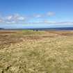
DP 153310
General shot.
RCAHMS Field Survey Digital Photography
10/5/2013
© Crown Copyright: HES

DP 153311
General shot of the most well-preserved barrow (5).
RCAHMS Field Survey Digital Photography
10/5/2013
© Crown Copyright: HES

DP 153312
General shot of two barrows, shown by red markers.
RCAHMS Field Survey Digital Photography
10/5/2013
© Crown Copyright: HES

DP 153313
Detail of one of the less well-preserved barrows. The tape runs across its diameter.
RCAHMS Field Survey Digital Photography
10/5/2013
© Crown Copyright: HES

DP 153314
General shot of four of the barrows (Nos. 1-4), marked by Mr A Fulton, and three other items.
RCAHMS Field Survey Digital Photography
10/5/2013
© Crown Copyright: HES

DP 153315
General shot.
RCAHMS Field Survey Digital Photography
10/5/2013
© Crown Copyright: HES